TQ6254 : Benchmark on Trig Pillar, Hurst Wood
taken 3 years ago, near to Crouch, Kent, England
Mereworth Woods is a large area of Ancient Semi-Natural Woodland and scrub between Maidstone and West Malling. It is part of the Metropolitan Green Belt and lies within a Special Landscape Area and is a Site of Nature Conservation Interest. Part of the woodland is used as an MOD training area. Footpaths and biking trails cross the woodland. The southern part of the woods is called Hurst Wood, the eastern part is Great Leybourne Wood and the northern section is Shipbourne Forest.
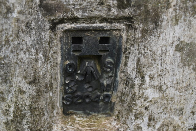
A triangulation station, also known as a triangulation pillar, trigonometrical station, trigonometrical point, trig station, trig beacon or trig point. Erected by the Ordnance Survey.
See Linkfor more details about Trig Stations.
The term benchmark, originates from the chiselled horizontal marks that surveyors made in stone structures, into which an angle-iron could be placed to form a "bench" for a levelling rod, thus ensuring that a levelling rod could be accurately repositioned in the same place in future. These marks were usually indicated with a chiselled arrow below the horizontal line.
The height of a benchmark is calculated relative to the heights of nearby benchmarks in a network extending from a fundamental benchmark, a point with a precisely known relationship to the level datum of the area, typically mean sea level. The position and height of each benchmark is shown on large-scale maps.
 Map © Crown Copyright")
- Grid Square
- TQ6254, 96 images (more nearby 🔍)
- Photographer
- N Chadwick (more nearby)
- Date Taken
- Friday, 21 May, 2021 (more nearby)
- Submitted
- Tuesday, 10 August, 2021
- Subject Location
-
OSGB36:
 TQ 6299 5437 [10m precision]
WGS84: 51:15.9111N 0:20.0898E - Camera Location
-
OSGB36: TQ 6299 5437
- View Direction
- EAST (about 90 degrees)