2021
SO9807 : Old Milestone, A417 Duntisbourne Abbots
taken 3 years ago, near to Duntisbourne Leer, Gloucestershire, England
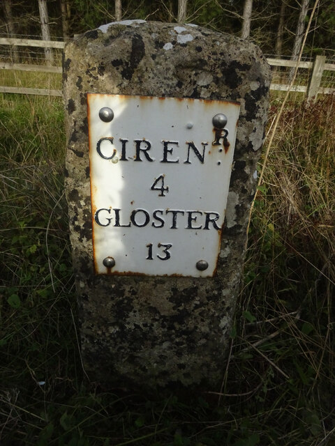
Old Milestone, A417 Duntisbourne Abbots
Metal plate attached to stone post by the A417, in parish of DUNTISBOURNE ABBOTS (COTSWOLD District), North of Dartley Farm (southbound carriageway), by the North East side of road. Cirencester iron plate, erected by the Cirencester to Birdlip turnpike trust in the 19th century.
Inscription reads:- : CIRENᴿ / 4 / GLOSTER / 13
Milestone Society National ID: GL_LG94
Inscription reads:- : CIRENᴿ / 4 / GLOSTER / 13
Milestone Society National ID: GL_LG94
National Survey of Wayside Features by The Milestone Society
These images are from Link
 Map © Crown Copyright")
TIP: Click the map for more Large scale mapping
- Grid Square
- SO9807, 14 images (more nearby 🔍)
- Photographer
- Mr Red (more nearby)
- Date Taken
- Monday, 11 October, 2021 (more nearby)
- Submitted
- Monday, 11 October, 2021
- Subject Location
-
OSGB36:
 SO 98831 07538 [1m precision]
WGS84: 51:45.9912N 2:1.1005W - Camera Location
-
OSGB36: SO 98831 07538
- View Direction
- Northeast (about 45 degrees)