SK9870 : Foundation stone, former chapels at the Old Cemetery, Canwick Road, Lincoln
taken 4 years ago, near to Canwick, Lincolnshire, England
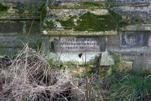
Under the Public Health Act of 1848 moves were started on a new cemetery but due to procrastination the Board of Health intervened whereby all Lincoln churchyards below hill were to be closed by October 1854 except the new St Swithin cemetery in Rosemary lane. In May 1854 the Lincoln Cemetery Committee (later setting up a Burial Board) had decided to appeal to the city's "affluent citizens" to contribute to the project saying that if two-thirds of the parishes concurred it would subscribe towards expenses. Controversy remained about the site of the cemetery and in March 1855 a vote settled the matter 42-23 for the cow paddle. The sixteen acres of land cost the Board £1,150 and the final bill for land, landscaping and buildings was £5,700. The land sale was strongly opposed by local residents and a formal petition was sent to the corporation signed by Residents Householders and Freemen of the City of Lincoln. The land was common land and Robeys also acquired a further six- and three-quarter acres of the Cow Paddle. Commoners were compensated with an additional seventeen and a half acres still also known as the Cow Paddle and still common land. It was not until 1870 a private act passed and legalised the changes, some retrospectively. 20th October 1855 crowds, including 2000 schoolchildren, attended when Richard Carline, the chairman of the Burial Board, made a welcome speech in which he confirmed that the city's churches were to be closed to burials and then laid the foundation stone. Included was a bottle "sealed with the Burial Board seal, and containing the current coins of the realm and a roll of parchment, on which was inscribed the names of members of the Burial Board and the clerks and officials". A brass plate marks the place where the stone was laid. The first interment at the new Cemetery took place on 3rd August 1856; a baby, 16-week-old John Allison of the parish of St Peter at Arches. Burials were overseen by Anglican vicars, rectors, curates and a Baptist Minister indicating its non-denominational nature. Corpses arrived from parishes across Lincoln, including Saint Michael on the Mount, Saint Benedict, Saint Martin, Saint Paul, and Saint Peter at Gowts. The Burial Board ceased to exist in 1907 when Lincoln became a single civil parish and the cemeteries were taken over by the City Council.
 Map © Crown Copyright")
- Grid Square
- SK9870, 75 images (more nearby 🔍)
- Photographer
- Jo and Steve Turner (more nearby)
- Date Taken
- Monday, 30 December, 2019 (more nearby)
- Submitted
- Sunday, 2 January, 2022
- Subject Location
-
OSGB36:
 SK 9830 7002 [10m precision]
WGS84: 53:13.0891N 0:31.7564W - Camera Location
-
OSGB36: SK 9830 7003
- View Direction
- South-southeast (about 157 degrees)