2022
TF9119 : Mileham village sign
taken 2 years ago, near to Mileham, Norfolk, England
This is 1 of 2 images, with title Mileham village sign in this square
Mileham village sign
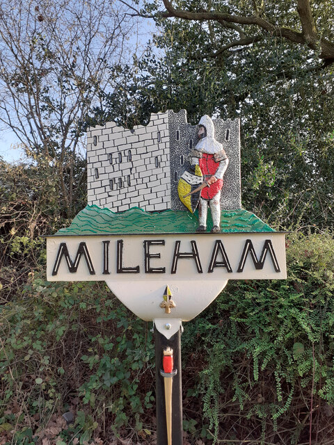
The sign has just been re-erected after renovation, the most noticeable difference is that now the face of the Norman soldier can be clearly seen, compared with Link
The sign shows the cattle keep, built around the early 12th century. The castle which was in the field behind the sign, was surrounded by a moat but nothing is showing above ground in the present day. The sword on the post is a representation of the one discovered in 1945 and is now housed in Norwich Castle Museum. A plaque on the base reads... "Mileham village sign erected in 1973. It stands on the site of the Parish Charity Coal House, flint from which forms this base."
The sign shows the cattle keep, built around the early 12th century. The castle which was in the field behind the sign, was surrounded by a moat but nothing is showing above ground in the present day. The sword on the post is a representation of the one discovered in 1945 and is now housed in Norwich Castle Museum. A plaque on the base reads... "Mileham village sign erected in 1973. It stands on the site of the Parish Charity Coal House, flint from which forms this base."
Village Signs of East Anglia
Village signs are typically placed along the principal road or in a prominent location such as a village green or close by the church. The design often depicts a particularly feature of the village or a scene from its history, heritage, or culture. They are typically made of wood or metal or a combination of both, the designs are often made by the local community.
Although they do appear in villages and towns all over the country they are more prominent in East Anglia than elsewhere in the country.
 Map © Crown Copyright")
TIP: Click the map for more Large scale mapping
- Grid Square
- TF9119, 38 images (more nearby 🔍)
- Photographer
- Jane Rackham (more nearby)
- Contributed by
- Adrian S Pye (more nearby)
- Date Taken
- February 2022 (more nearby)
- Submitted
- Thursday, 3 February, 2022
- Subject Location
-
OSGB36:
 TF 91538 19378 [1m precision]
WGS84: 52:44.2856N 0:50.1434E - Camera Location
-
OSGB36: TF 9152 1938
- View Direction
- Southeast (about 135 degrees)