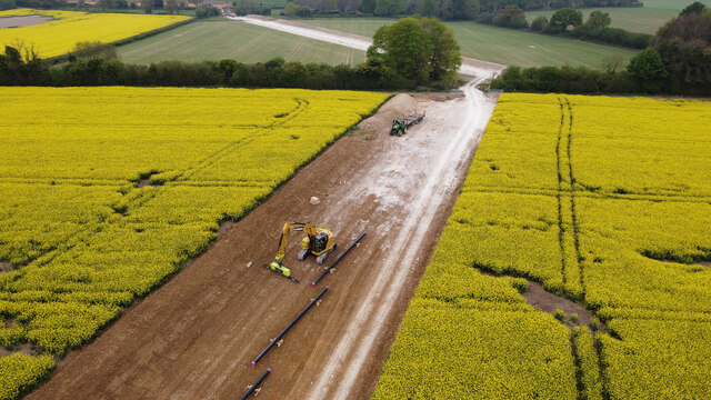
SU6126 : The steel pipes laid beside the haul road
taken 2 years ago, near to Bramdean, Hampshire, England
In October 2020 Esso Petroleum Company obtained the Southampton to London Pipeline Development Consent Order 2020, permitting them to constuct a new fuel pipeline of diameter 330 mm from Boorley Green to the West London Terminal storage facility in Hounslow. It would carry high-pressure aviation fuel produced at their Fawley refinery to Heathrow airport.
The official web site of the project was Link.
The new pipeline would follow the route of an existing one which was coming to the end of its life, but without disrupting it.
Works first became visible in Hampshire in 2022 when lots of little rectangular fenced pens were created, in pairs, on either side of certain roads. The purpose of these pens was to enclose land needed to operate machines to take the pipeline beneath these roads. Two methods were mainly used: pipe pushing and auger boring depending, it seems, upon the nature of the ground. Pipe pushing could not be used in hard ground like flinty chalk.
Earlier, in 2020, short surface scrapes could be seen on Google Earth, running diagonally across the line of the pipe and making a zig zag form. These were preliminary archaeological surveys.
 Map © Crown Copyright")
- Grid Square
- SU6126, 46 images (more nearby 🔍)
- Photographer
- Peter Facey (more nearby)
- Date Taken
- Tuesday, 3 May, 2022 (more nearby)
- Submitted
- Monday, 16 May, 2022
- Subject Location
-
OSGB36:
 SU 6148 2697 [10m precision]
WGS84: 51:2.3284N 1:7.4700W - Camera Location
-
OSGB36: SU 61587 27104
- View Direction
- Southwest (about 225 degrees)