1974
SE4521 : View up to St. Giles, from Woolmarket
taken 50 years ago, near to Pontefract, Wakefield, England
View up to St. Giles, from Woolmarket
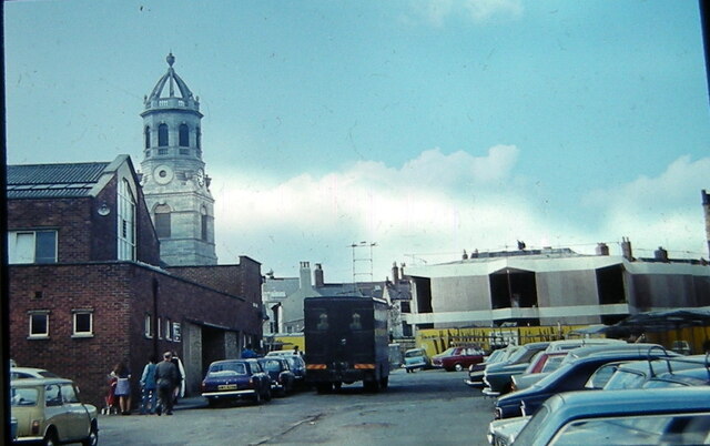
Two months ago, my mother passed away, and - looking through the family colour slides - I found this gem, as regards Pontefract's architectural history.
My late father dated this slide August 1974, when the 'new' library was being built. As a kid, I remember going to the old library (now Pontefract museum) as, going up the stairs, there was always a distinctive smell (cleaning products?). By contrast, the 'new' library seemed enormous, at first.
Note how Pomfretians parked their cars in the town centre, without worrying.
Most important of all, 'Middle Row' - or at least part of it - is visible (on the far left.) Unfortunately, Middle Row is one of many parts of Pontefract's history that were demolished, in the name of progress.
 Map © Crown Copyright")
TIP: Click the map for more Large scale mapping
- Grid Square
- SE4521, 435 images (more nearby 🔍)
- Photographer
- Jim Beadham (more nearby)
- Contributed by
- Phillip Beadham (more nearby)
- Date Taken
- Monday, 19 August, 1974 (more nearby)
- Submitted
- Tuesday, 21 June, 2022
- Subject Location
-
OSGB36:
 SE 4552 2192 [10m precision]
WGS84: 53:41.5051N 1:18.7283W - Camera Location
-
OSGB36: SE 4556 2195
- View Direction
- West-southwest (about 247 degrees)