TF3242 : Black Sluice Pumping Station
taken 2 years ago, near to Boston, Lincolnshire, England
Black Sluice and the South Forty Foot drain were part of the battle to drain the fens to create more land to harvest crops. But the Fenmen, who had rights to fish and graze their livestock there during the summer, put up a fight to save their livelihoods.
The South Forty Foot drain was first dug in the 1630s to drain Holland fen. Engineers devised a long straight channel to take the water faster to the River Witham where it flowed out to sea. The sluice was built to stop the tide running far inland. Large scale drainage of the fens took place at this time financed by speculators known as "Adventurers".
There was violent resistance and houses, farms and corn stacks on the land were destroyed. The wooden gates of the sluice were burnt leaving them charred black and useless. The fen men drove the Adventurers off the huge common fen.
Over 100 years later, a second sluice was built to relieve the flooding that had continued. The fenmen rioted in Boston, and the militia was sent to prevent the town being burned down. Several years of violence followed but this time, the drainage schemes went ahead. So began the transformation of the fens into the agricultural landscape we see today.
The South Forty Foot drain was dug by labourers using picks, shovels and barrows These tools were still used by navvies clearing silt from drains and rivers until the early 1900s.
The resident engineer to the River Witham commissioners was William Lewin (1794 to 1863), and the third and present Black Sluice was constructed in 1846.
Since 1946, water draining from Holland fen into the South Forty Foot has been pumped into the tidal section of the Witham known locally as the Haven.
The Black Sluice lock at Boston gives boaters access to the South Forty Foot drain as far as Donington High bridge, a distance of 16 km. This lock, opened in 2009, is the first phase of the fens waterways Link.
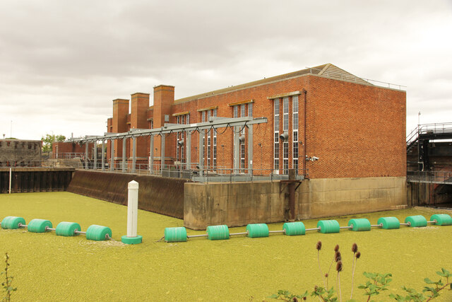
Black Sluice is the outfall of the South Forty Foot drain into the tidal section of the River Witham known locally as the Haven the sluice and the drain are part of an intricate network of waterways pumps and locks that continue to perform the essential task of draining the lands to reduce the risk of flooding.
Although the station is responsible for pumping the area of the Black Sluice Internal Drainage Board, it is operated by the Environment Agency, not the Board. This resulted from the Sluice and the South Forty Foot Drain being taken over by the Witham and Steeping Rivers Catchment Board in 1935, then passing to the Rivers Authority and finally to the Environment Agency..
The northern part of the Station was the original pumping station, opened in 1946 with 3 Ruston 900hp pumps. Requirements for additional pumping in its area by the IDB resulted in a need for additional pumping capacity at Black Sluice. The then operator, the Lincolnshire Rivers Board, added two further pumps, by English Electric of 975 hp, in a southern extension to the building. An information panel outside the station states that there have only been three occasions, in 1968, 1977 and 1981 when all five pumps have been run together.
There was a lock at the sluice until 1971, although there is no evidence for a right of navigation on the drains. However, following pressure to revitalise leisure navigation on the drains, a new lock was opened in 2009 as part of the Fens Waterway Link.
A history of the IDB can be found here Link
 Map © Crown Copyright")
- Grid Square
- TF3242, 109 images (more nearby 🔍)
- Photographer
- Richard Croft (more nearby)
- Date Taken
- Tuesday, 2 August, 2022 (more nearby)
- Submitted
- Monday, 8 August, 2022
- Subject Location
-
OSGB36:
 TF 3263 4287 [10m precision]
WGS84: 52:58.0077N 0:1.5970W - Camera Location
-
OSGB36: TF 3259 4285
- View Direction
- East-northeast (about 67 degrees)