2022
TF9143 : Bang, 2 Staithe Street, Wells-next-the-Sea
taken 2 years ago, near to Wells-Next-The-Sea, Norfolk, England
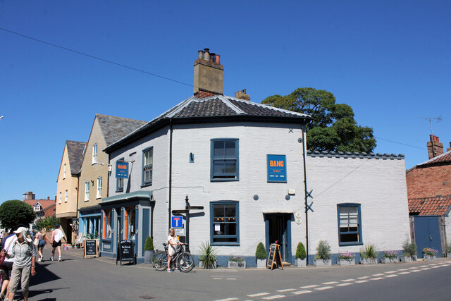
Bang, 2 Staithe Street, Wells-next-the-Sea
Grade II Listed as the Corner House, the early 19th century building was formerly the Prince of Wales Public House. In 2005 archaeological excavations here revealed the first Iron Age and Roman remains found in Wells. The Corner House was a restaurant with wine bar and accommodation from at least 1972, possibly from c.1966 when the pub closed. The current (2022) business 'Bang' has a ground floor bistro & bar with four guest bedrooms on the first floor. It seems there was a Prince of Wales in the High Street that was previously the King William IV and can be confused with this location. This was initially a shop known as the Tewkesbury Stores that probably became a beer house and was known as the Tewkesbury Arms in 1871 although still referred to as stores after that date. In September 1887 William Gurling/Girling obtain the transfer of spirit licence from the Prince of Wales to the Tewkesbury Stores that was renamed the Prince of Wales when the house by that name, in the High Street, closed. William Gurling was licensee to at least 1892 and after that we have; 1896-1912 William Woodcock Grange; 1924 Elizabeth Grange then Herbert Hayter; 1925 Albert Charles Williams; 1929 Frank Reginald Wells; 1935 Sidney Allen; 1953 Norton Louis Hill Allen; 1956 Winifred Vivian Allen; Nov.1963 to closure Ronald Richard Bouchier Bishop.
 Map © Crown Copyright")
TIP: Click the map for more Large scale mapping
- Grid Square
- TF9143, 886 images (more nearby 🔍)
- Photographer
- Jo and Steve Turner (more nearby)
- Date Taken
- Sunday, 10 July, 2022 (more nearby)
- Submitted
- Sunday, 14 August, 2022
- Subject Location
-
OSGB36:
 TF 9169 4347 [10m precision]
WGS84: 52:57.2607N 0:51.1273E - Camera Location
-
OSGB36: TF 9169 4346
- View Direction
- North-northeast (about 22 degrees)