2022
NS9874 : Northern End of Cockleroy Ridge
taken 2 years ago, 3 km from Linlithgow Bridge, West Lothian, Scotland
Northern End of Cockleroy Ridge
There are two main ways to walk Cockleroy, a prominent feature in the Bathgate Hills. You can go up and down directly from the nearby big car park, which takes around 15 minutes. Or you can veer right from the approach from the car park onto a narrow but obvious path which goes round its Eastern slope until you get to a copse of conifers, then head up to the ridge at a point to the North of its summit before doubling back on yourself - this probably takes about double the time.
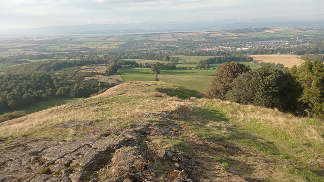
Or you can just start the easy way and keep walking. There is a faint path leading down to the hill's Northern base, which is where this picture was taken from. It gets pretty steep for a while close to the bottom. The faint path just peters out into a field, so it's hard to know whether most people who go this way just head back up to the top, or if there are so few people that do it that they all go in different directions to complete a long circuit.
There is usually the odd mountain biker doing the easy route (I imagine it's not quite as easy for them though), and I think they would enjoy the rocky downhill to the bottom here. It is, however, unlikely that they would be able to do the ride the other way - unless they are Tom Pidcock - so a lot of bike-pushing would be involved, which probably explains their absence.
 Map © Crown Copyright")
TIP: Click the map for more Large scale mapping
- Grid Square
- NS9874, 38 images (more nearby 🔍)
- Photographer
- Ian Dodds (more nearby)
- Date Taken
- Monday, 5 September, 2022 (more nearby)
- Submitted
- Monday, 5 September, 2022
- Subject Location
-
OSGB36:
 NS 9884 7457 [10m precision]
WGS84: 55:57.2082N 3:37.2992W - Camera Location
-
OSGB36: NS 9884 7457
- View Direction
- NORTH (about 0 degrees)