2022
ST1971 : Penarth Pier, The Esplanade, Penarth
taken 2 years ago, near to Penarth, The Vale of Glamorgan/Bro Morgannwg, Wales
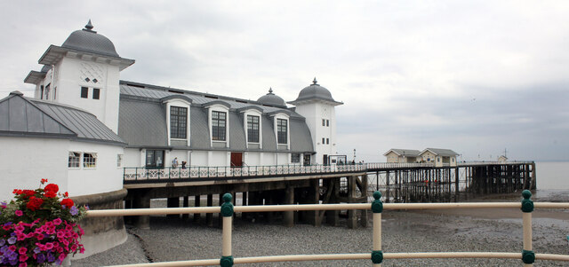
Penarth Pier, The Esplanade, Penarth
Grade II Listed 200m long pier with only the central section on cast iron piles and wooden decking being original. It was built to a design by Herbert Francis Edwards from April 1894 to 4th February 1895 opening. The 15m wide concrete landing stage was added in 1926. The original toll houses and shops were demolished and the much bigger pavilion was built requiring the landward end of the pier widened by the firm of Messrs MacDonald of Avergavenney, to incorporate a supporting concrete frame. It was all opened on 18th May 1929. The pavilion itself had been built by Messrs E J Smith of Cardiff and designed by M F Edwards. The new pavilion meant that the pier now had two pavilions, one at each end. Initially, the old pavilion became very run down but in 1930 it was refurbished and re-opened as a dance hall. This hall on the seaward end of the pier burnt down, destroying wooden decking and all other buildings on the pier except the present pavilion on August Bank Holiday Monday 1931. The pier was rebuilt at a cost of £3,157, but the wooden pavilion was not replaced. In May 1947 more rebuilding was carried out after Canadian merchant ship, Port Royal Park struck the pier buckling the decking and fracturing or pushing out of alignment over 70 of the main supporting cast-iron columns. The pier didn't reopen until 4th June 1949. From 1994 to 1998 over £3m was spent on repairs and restoration. Between November 2009 and December 2013 the pier and pavilion underwent a restoration and renovation scheme costing around £4.2m.
 Map © Crown Copyright")
TIP: Click the map for more Large scale mapping
- Grid Square
- ST1971, 113 images (more nearby 🔍)
- Photographer
- Jo and Steve Turner (more nearby)
- Date Taken
- Thursday, 28 July, 2022 (more nearby)
- Submitted
- Saturday, 17 September, 2022
- Subject Location
-
OSGB36:
 ST 1900 7132 [10m precision]
WGS84: 51:26.1040N 3:9.9991W - Camera Location
-
OSGB36: ST 1893 7130
- View Direction
- East-northeast (about 67 degrees)