2022
ST1871 : Beachcliff, The Esplanade, Penarth
taken 2 years ago, near to Penarth, The Vale of Glamorgan/Bro Morgannwg, Wales
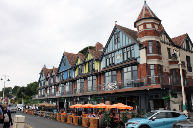
Beachcliff, The Esplanade, Penarth
This Terrace of 5 separate properties was originally designed and built in 1904 by Frederick Speed. Initial occupants were Beach Cliff private hotel, Stephens & Co. toy and fancy Bazaar, O.G. Williams, restaurant and confectioner, Stuart Hall, and G.F. Meridith, toys and fancy goods. The Rabaiotti family took over Beachcliff in the 1950s, operating Italian restaurants and cafes until the building was sold in the early 2000s. Cardiff based property developers bought the building in 2007 and produced a £6m plan for the building designed by John Wotton Architects that was granted planning consent in March 2009. Work uncovered the full extent of the structures decay, and in Googles July 2012 Street View you can see the demolished building and that only the two end towers and some of the end walls remain. Based on early photographs, the new building appears a faithful replica, in the façade at least, of the original. The ground floor commercial units seem to have been in use as a restaurant 2015. By March 2016 it is reported that two apartments were for sale and three town houses were nearing completion. In March 2016 'Restaurant James Sommerin' were offering up to nine rooms in a new boutique hotel (in addition to the flats and houses) over the ground floor restaurant.
 Map © Crown Copyright")
TIP: Click the map for more Large scale mapping
- Grid Square
- ST1871, 524 images (more nearby 🔍)
- Photographer
- Jo and Steve Turner (more nearby)
- Date Taken
- Thursday, 28 July, 2022 (more nearby)
- Submitted
- Sunday, 18 September, 2022
- Subject Location
-
OSGB36:
 ST 1890 7124 [10m precision]
WGS84: 51:26.0600N 3:10.0843W - Camera Location
-
OSGB36: ST 1892 7127
- View Direction
- Southwest (about 225 degrees)