2022
SP5214 : Information Board in Islip
taken 2 years ago, near to Islip, Oxfordshire, England
Information Board in Islip
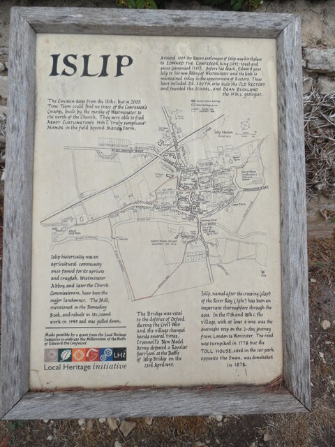
This information board with a street map of Islip, is located off the High Street and to the east of St Nicholas Parish Church. It was made possible by a grant from the Local Heritage Initiative to celebrate the Millennium of the Birth of Edward the Confessor. It has the following wording:
Top left
The CHURCH dates from the 13th c. but in 2005 Time Team could find no trace of
the CONFESSOR'S CHAPEL built by the monks of Westminster to the north of the
Church. They were able to find ABBOT CURTLINGTON'S 14th c. 'truly sumptuous'
MANOR in the field beyond Manor Farm.
Top right
Around 1005 the Saxon settlement of Islip was birthplace to EDWARD THE
CONFESSOR, king (1042-1066) and saint (canonised 1161). Before his death,
Edward gave Islip to his new Abbey of Westminster and the link is maintained
today in the appointment of Rectors. These have included DR.SOUTH, who built
the OLD RECTORY and founded the SCHOOL, and DEAN BUCKLAND, the 19th
c.geologist.
Bottom left
Islip historically was an agricultural community, once famed for its apricots
and crayfish. Westminster Abbey, and later the Church Commissioners, have been
the major landowner. The Mill, mentioned in the Domesday Book, and rebuilt in
18thc., ceased work in 1949 and was pulled down.
Bottom middle
The Bridge was vital to the defence of Oxford during the Civil War and the
village changed hands several times.
Cromwell's New Model Army defeated a Royalist Garrison at the Battle of Islip
Bridge on the 23rd April 1645.
Bottom right
Islip, named after the crossing (slaep) of the River Ray (Ight) has been an
important thoroughfare through the ages. In the 17th and 18th c. the village,
with at least 6 inns, was the overnight stop on the 2-day journey from London
to Worcester. The road was turnpiked in 1778 but the TOLL HOUSE, sited in the
car park opposite the Swan, was demolished in 1878.
 Map © Crown Copyright")
TIP: Click the map for more Large scale mapping
- Grid Square
- SP5214, 74 images (more nearby 🔍)
- Photographer
- David Hillas (more nearby)
- Date Taken
- Saturday, 3 September, 2022 (more nearby)
- Submitted
- Thursday, 10 November, 2022
- Subject Location
-
OSGB36:
 SP 5270 1412 [10m precision]
WGS84: 51:49.3935N 1:14.2064W - Camera Location
-
OSGB36: SP 5271 1410
- View Direction
- North-northwest (about 337 degrees)