J4782 : The North Down Coastal Path at Swineley Bay
taken 1 year ago, near to Crawfordsburn, Co Down, Northern Ireland
This is 1 of 2 images, with title The North Down Coastal Path at Swineley Bay in this square
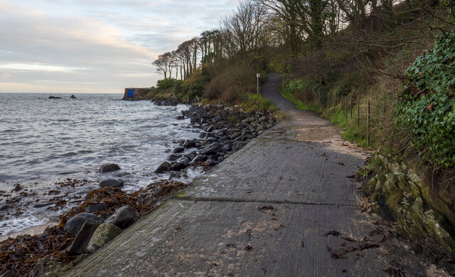
The North Down Coastal Path at Swineley Bay
The path at the east end of Swineley Bay. Here the path ends the beach on a large concrete section (usually very slippery so care must be taken) which then connects, via a short but very steep and uneven hill, with the man-made tarmac surface towards Carnalea.
The North Down Coastal Path
The North Down Coastal Path extends for some 16 miles between Holywood and Orlock in north County Down. Although it has always been possible to walk the entire route along the shoreline, prior to 1970 much of the area was still in private ownership. In the 1960s, the government, local councils and National Trust worked to together to get the path fully accessible and opened to all. This included, in many places, extensive works to create concrete and tarmac routes over what was the natural environment between Holywood and Bangor. Beyond Bangor it remains much wilder and unspoilt, particularly on the sections at Ballymacormick Point and Orlock. It was formally opened in 1971.
See Linkfor further information and maps.
![Creative Commons Licence [Some Rights Reserved]](https://s1.geograph.org.uk/img/somerights20.gif)
|
· Find out How to reuse this image ·
Share:
|
|||||
| Start a discussion on J4782 | Suggest an update to this image | Contact the contributor | |||
Loading map... (JavaScript required)
- Grid Square
- J4782, 33 images (more nearby
 )
)
- Photographer
- Rossographer (find more nearby)
- Date Taken
- Tuesday, 22 November, 2022 (more nearby)
- Submitted
- Friday, 25 November, 2022
- Geographical Context
- Primary Subject of Photo
- Subject Location
-
Irish:
 J 4764 8232 [10m precision]
WGS84: 54:40.0411N 5:42.7460W - Camera Location
-
Irish: J 4762 8231
- View Direction
- Northeast (about 45 degrees)
Other Tags
This page has been viewed about 55 times.
View this location:
KML (Google Earth) ·
Google Maps ·
Bing Maps ·
Geograph Coverage Map ·
More Links for this image