2022
NT0264 : Walled section of West Calder Burn
taken 1 year ago, near to Polbeth, West Lothian, Scotland
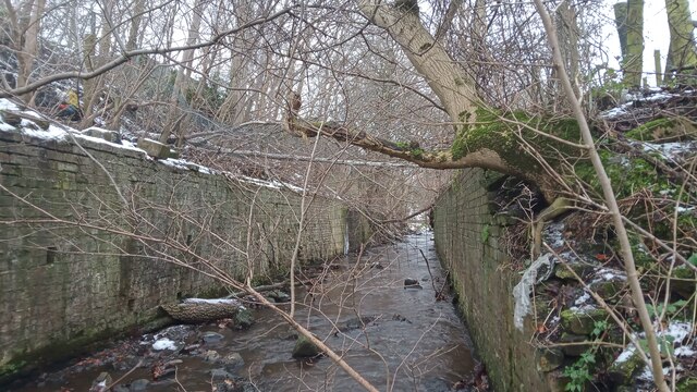
Walled section of West Calder Burn
It isn't that obvious why it was decided that there was the need to build these two massive retaining walls. They are definitely here because, just South of the road bridge - which has been present in some shape or form for at least 200 years - there used to be a railway line serving two or more shale mines crossing the burn where the walls now sit.
Old OS maps show that the railway didn't cross the water via an actual bridge however; the water disappears from the maps for a short but significant length, indicating that a culvert was built and earth piled on top to facilitate a wide crossing and to keep the track horizontal. Considering the amount of earth that must have had to be taken away to get to the culvert it seems odd that they didn't just take the final loads away from the banks to save building the wall. Or just leave the whole thing in place - a wide crossing over a culvert built for exactly the same reasons is still in place a few hundred yards upstream. The crossing was still in place in the 1960s (though it was then a track as opposed to a railway), so there are probably still people alive who did the work - I'll have to ask about...
Old OS maps show that the railway didn't cross the water via an actual bridge however; the water disappears from the maps for a short but significant length, indicating that a culvert was built and earth piled on top to facilitate a wide crossing and to keep the track horizontal. Considering the amount of earth that must have had to be taken away to get to the culvert it seems odd that they didn't just take the final loads away from the banks to save building the wall. Or just leave the whole thing in place - a wide crossing over a culvert built for exactly the same reasons is still in place a few hundred yards upstream. The crossing was still in place in the 1960s (though it was then a track as opposed to a railway), so there are probably still people alive who did the work - I'll have to ask about...
 Map © Crown Copyright")
TIP: Click the map for more Large scale mapping
- Grid Square
- NT0264, 28 images (more nearby 🔍)
- Photographer
- Ian Dodds (more nearby)
- Date Taken
- Sunday, 18 December, 2022 (more nearby)
- Submitted
- Monday, 19 December, 2022
- Subject Location
-
OSGB36:
 NT 0245 6430 [10m precision]
WGS84: 55:51.7186N 3:33.6093W - Camera Location
-
OSGB36: NT 0245 6430
- View Direction
- South-southeast (about 157 degrees)