2012
SK0581 : Old Boundary Marker on the A624 Hayfield Road
taken 12 years ago, near to Chapel-en-le-Frith, Derbyshire, England
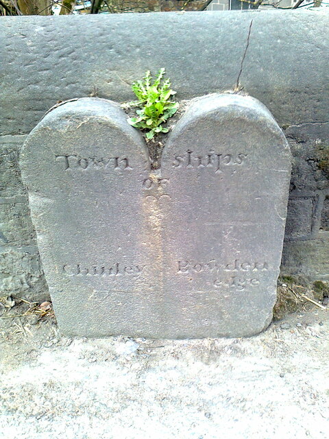
Old Boundary Marker on the A624 Hayfield Road
Township Boundary Marker standing against the parapet of a bridge on the east side of the A624 Hayfield Road immediately north of its junction with Bowden Lane. It marks the former boundary of Chinley and Bowden Edge townships in Glossop and Chapel-en-le-Frith parishes respectively, and now the boundary of Chinley, Buxworth and Brownside parish and Chapel-en-le-Frith parish.
Milestone Society National ID: DE_CHACBB01pb
Milestone Society National ID: DE_CHACBB01pb
National Survey of Wayside Features by The Milestone Society
These images are from Link
 Map © Crown Copyright")
TIP: Click the map for more Large scale mapping
- Grid Square
- SK0581, 90 images (more nearby 🔍)
- Photographer
- D Garside (more nearby)
- Contributed by
- Mike Rayner (more nearby)
- Date Taken
- Friday, 16 March, 2012 (more nearby)
- Submitted
- Monday, 2 January, 2023
- Subject Location
-
OSGB36:
 SK 05668 81773 [1m precision]
WGS84: 53:19.9703N 1:54.9810W - Camera Location
-
OSGB36: SK 05668 81773
- View Direction
- Northeast (about 45 degrees)