1994
NG4725 : West ridge of Sgùrr nan Gillean
taken 30 years ago, near to Knight's Peak [hill or Mountain], Highland, Great Britain
This is 1 of 3 images, with title West ridge of Sgùrr nan Gillean in this square
West ridge of Sgùrr nan Gillean
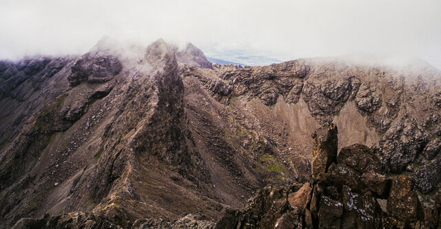
The west ridge of Sgùrr nan Gillean descending from the summit, its route emphasised by the pale line of the path along its crest. Beyond the col the ridge rises to Am Basteir which is the nearest of the peaks with mist wisping around its summit.
Coire a' Bhàsteir is the rocky bowl to the right of the ridge and Sgùrr a' Bhàsteir is the more brightly lit mountain above it, also misted.
Coire a' Bhàsteir is the rocky bowl to the right of the ridge and Sgùrr a' Bhàsteir is the more brightly lit mountain above it, also misted.
 Map © Crown Copyright")
TIP: Click the map for more Large scale mapping
- Grid Square
- NG4725, 59 images (more nearby 🔍)
- Photographer
- Trevor Littlewood (more nearby)
- Date Taken
- Sunday, 21 August, 1994 (more nearby)
- Submitted
- Thursday, 19 January, 2023
- Subject Location
-
OSGB36:
 NG 4708 2529 [10m precision]
WGS84: 57:14.8887N 6:11.6667W - Camera Location
-
OSGB36: NG 4716 2528
- View Direction
- WEST (about 270 degrees)