2023
NZ0648 : Engine house, Dene Howl
taken 1 year ago, near to Healeyfield, County Durham, England
This is 1 of 2 images, with title Engine house, Dene Howl in this square
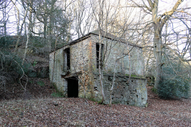
Engine house, Dene Howl
"The winding house is square in plan, built of stone with brick details, and retains quite a good corrugated sheet roof. It appears to have been much altered during its life working for the mine but is still in reasonable condition although empty and disused with no remains of engine foundations. Judging from the blocked openings in the front wall it may have both wound and pumped the shaft originally."
Cleveland Mining Heritage Society - Saturday 15th March 2014 Away day Report: Link (Archive Link ) Archive Link (Archive Link )
There is an old postcard showing the engine house in around 1880 with its tall square-sectioned chimney in the background of a range of other mine buildings, now gone, here: Link Archive Link
Cleveland Mining Heritage Society - Saturday 15th March 2014 Away day Report: Link
There is an old postcard showing the engine house in around 1880 with its tall square-sectioned chimney in the background of a range of other mine buildings, now gone, here: Link
Lead mining remains at Dene Howl :: NZ0748
The remains at Dene Howl are part of Healeyfield Lead Mine.
Lead mining was an important industry in Healeyfield Parish for many years. Healeyfield Lead Mine was located at Dene Howl, about half a mile west from the crossroads at Castleside. The mine closed in 1891 after a long history dating back some 800 years, and yielded not only lead but also large quantities of silver. It was owned by the Dean and Chapter of Durham Cathedral, pre-reformation called the Benedictine Priory of Durham and was a supplier of silver to its Mint.
 Map © Crown Copyright")
TIP: Click the map for more Large scale mapping
- Grid Square
- NZ0648, 76 images (more nearby 🔍)
- Photographer
- Andrew Curtis (more nearby)
- Date Taken
- Wednesday, 25 January, 2023 (more nearby)
- Submitted
- Wednesday, 25 January, 2023
- Subject Location
-
OSGB36:
 NZ 0685 4860 [10m precision]
WGS84: 54:49.9311N 1:53.6934W - Camera Location
-
OSGB36: NZ 06842 48600
- View Direction
- Northeast (about 45 degrees)