2023
SP2965 : Semi-detached houses, Charles Street, Warwick
taken 1 year ago, near to Warwick, Warwickshire, England
This is 1 of 2 images, with title Semi-detached houses, Charles Street, Warwick in this square
Semi-detached houses, Charles Street, Warwick
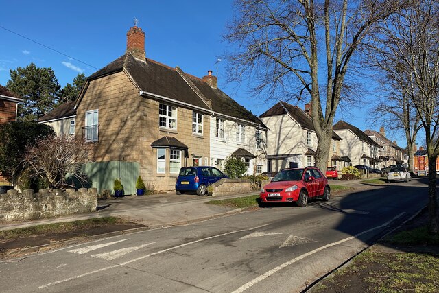
These houses were built by the Nelson family for workers at Emscote Mills by the canal, where the company manufactured several grades and forms of gelatine and gelatine products from animal hides. The first two pairs of houses appear on a map of 1886. Eventually there were four pairs of houses on each side of Charles Street making 16 dwellings in all SP2965 : Semi-detached houses, Charles Street, Warwick, with two larger houses for foremen and their families in All Saints Road up the hill SP2966 : All Saints Road. The houses, and their front garden walls, are constructed from exposed-aggregate concrete blocks with fair-faced quoins at the corners. When built, the view down the hill would have been dominated by the four tall chimneys at the works. There is a YouTube video about the Nelsons, their global company and their products Link
 Map © Crown Copyright")
TIP: Click the map for more Large scale mapping
- Grid Square
- SP2965, 1818 images (more nearby 🔍)
- Photographer
- Robin Stott (more nearby)
- Date Taken
- Monday, 6 February, 2023 (more nearby)
- Submitted
- Sunday, 5 March, 2023
- Subject Location
-
OSGB36:
 SP 2946 6587 [10m precision]
WGS84: 52:17.4108N 1:34.1703W - Camera Location
-
OSGB36: SP 2947 6584
- View Direction
- North-northwest (about 337 degrees)