2023
SP1620 : Bakery on the Water, 1 Sherborne Street, Bourton-on-the-Water
taken 1 year ago, near to Bourton-on-The-Water, Gloucestershire, England
This is 1 of 2 images, with title starting with Bakery on the Water in this square
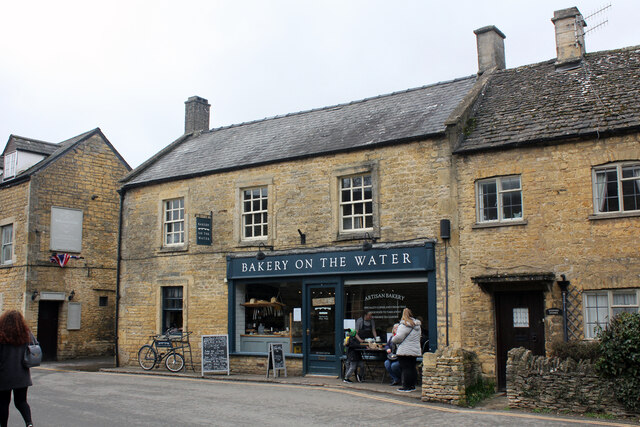
Bakery on the Water, 1 Sherborne Street, Bourton-on-the-Water
Early to mid 19th century building Grade II Listed as 'Teague's Shop' in 1983. By 1989 it seems to have been called 'The Old Bakery' suggesting it had been a bakery in the past. In the 19th and early 20th century it was the Bell Inn. The first directory I find beer retailers in Bourton is 1868 but I can't tell where. Gloucestershire Pubs & Breweries List 'Owner in 1891: Hunt Edmunds, Banbury' and the same again 1903. The landlords they list are 1891 William Tylor, 1903 William Giles, 1927 Herbert Ricketts. Directories are unspecific as to location but in 1897 I found 'Pratley Edwin, beer retailer & baker'. No evidence is found after 1927 of the continued existence of the Inn and the building was later known as Bell Cottage. The shop front was a 20th century addition. In 2011 it carried the name board 'Norths Cotswold Bakery' and had a for sale sign on the wall. By 2015 it was 'Bakery on the Water' but strangely I can find no sale recorded, however it had been vacant for about six months in October 2012. In January 2013 planning approved change of use of ground floor from retail and part residential to cafe, together with external alterations it had conversion of the ground floor residential area to cafe. At this time, the rear of the property and the first floor had been self-contained residential units. In 1991 planning had approved 'conversion of part cafe area to proposed letting bedroom' and in 1995 'change of use of ground floor bedroom and bathroom back to retail use'.
 Map © Crown Copyright")
TIP: Click the map for more Large scale mapping
- Grid Square
- SP1620, 634 images (more nearby 🔍)
- Photographer
- Jo and Steve Turner (more nearby)
- Date Taken
- Sunday, 12 March, 2023 (more nearby)
- Submitted
- Sunday, 19 March, 2023
- Subject Location
-
OSGB36:
 SP 1669 2067 [10m precision]
WGS84: 51:53.0606N 1:45.5353W - Camera Location
-
OSGB36: SP 1670 2068
- View Direction
- West-southwest (about 247 degrees)