2023
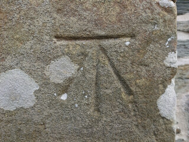
SN2045 : Ordnance Survey Benchmark - Llangoedmor, School House
taken 1 year ago, near to Llangoedmor, Ceredigion/Sir Ceredigion, Wales
This is 1 of 2 images, with title Ordnance Survey Benchmark - Llangoedmor, School House in this square
Ordnance Survey Benchmark - Llangoedmor, School House
Ordnance Survey Benchmark (OSBM) used for levelling height above Ordnance Datum (OD).
Height (1972): 43.1590m OD (Newlyn). Mark verified by the Ordnance Survey in 1975. Description: JUNC RDS NW FACE SCHOOL HOUSE. 0.8m above ground. 2nd Order BM.
Context: SN2045 : Ordnance Survey Benchmark - Llangoedmor, School House
Height (1972): 43.1590m OD (Newlyn). Mark verified by the Ordnance Survey in 1975. Description: JUNC RDS NW FACE SCHOOL HOUSE. 0.8m above ground. 2nd Order BM.
Context: SN2045 : Ordnance Survey Benchmark - Llangoedmor, School House
 Map © Crown Copyright")
TIP: Click the map for more Large scale mapping
- Grid Square
- SN2045, 13 images (more nearby 🔍)
- Photographer
- N Scott (more nearby)
- Date Taken
- Wednesday, 22 March, 2023 (more nearby)
- Submitted
- Wednesday, 22 March, 2023
- Subject Location
-
OSGB36:
 SN 2003 4580 [10m precision]
WGS84: 52:4.8734N 4:37.6713W - Camera Location
-
OSGB36: SN 2003 4580
- View Direction
- SOUTH (about 180 degrees)