NG9257 : Liathach from Meall Dearg
taken 11 years ago, 3 km from Torridon, Highland, Scotland
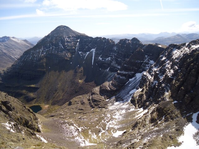
Below is the upper part of Coire na Caime.
Liathach is one of the big three Torridon mountains (the others are Beinn Eighe and Beinn Alligin) which between them boast six Munros and eight Tops. Of these, Liathach has two Munros and four Tops: Meall Dearg (often called Northern Pinnacles) is one of these four Tops. It is only just over 300 metres from the Munro of Mullach an Rathain, but is often regarded as the most difficult Top on the mainland to reach. (The Isle of Skye wears the crown in terms of difficulty!)
If you climb Meall Dearg from Mullach an Rathain on the main ridge, you need to be a competent (and confident!) rock climber to traverse the Northern Pinnacles. There is however an alternative route round the back, via Loch Coire na Caime and Coireag Cham above it, which is just a steep but exposed scramble. NG9157 : Mullach an Rathain from the east, taken from Spidean a' Choire Leith, is an excellent view of Mullach an Rathain (centre), the Northern Pinnacles just right of it, and Meall Dearg further right, with the Coireag Cham ascent route below.
I hope that the set of photos by Michael Earnshaw for which this Shared Description was originally prepared will demonstrate these points.
by David Purchase
 Map © Crown Copyright")
- Grid Square
- NG9257, 32 images (more nearby 🔍)
- Photographer
- Michael Earnshaw (more nearby)
- Contributed by
- David Purchase (more nearby)
- Date Taken
- Saturday, 25 May, 2013 (more nearby)
- Submitted
- Monday, 22 May, 2023
- Subject Location
-
OSGB36:
 NG 9234 5745 [10m precision]
WGS84: 57:33.5572N 5:28.3847W - Camera Location
-
OSGB36: NG 9138 5793
- View Direction
- East-southeast (about 112 degrees)