NS3474 : Timber ponds and coastal path
taken 16 years ago, near to Port Glasgow, Inverclyde, Scotland
Port Glasgow has been a ship building town since 1780 when Thomas McGill opened a yard here. 18th Century shipbuilding demanded a lot of timber and Port Glasgow was a major timber importer during this time. Massive shipments of prepared and unprepared timber were received from far flung places such as Canada, Norway and the Baltic states. Vast timber holding ponds were constructed to the east of Newark Castle, stretching three miles along the coast, beyond Parklea, to Langbank. These are still very much in evidence today and can be seen from land, sea and air. They are known locally as "the stabs".
There were also timber ponds in the west end of the town, but these were removed as the shipyards expanded and no trace remains today. The map of 1864 shows the "Kingston Sawmill", "timber yard" and "timber ponds" on the site where the Kingston shipyard later stood. That area is now a housing estate, with some light industry at Ardgowan Street.
The twenty or so surviving timber ponds stretch from just west of Kelburn Park in the east end of Port Glasgow to near the A8 railway bridge at Langbank.
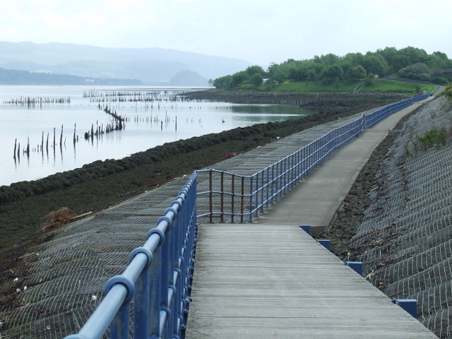
They are not really ponds in the traditional sense in that they do not hold water. They can be more accurately described as intertidal enclosures which are dry at low tide and flooded at high tide. The enclosures are mostly square in shape, their boundaries formed by lines of tall wooden stakes (known locally as "stabs") which are buried deep in the mud. It was within these enclosures that rafts of timber were stored.
As shipbuilding made the switch from timber to metal, the ponds fell into disuse and decline in the early part of the 20th Century.
Most of the area of the surviving timber ponds is within the Inner Clyde Nature Reserve which is managed by the RSPB, whose web site Linkdescribes it as follows - "The reserve contains internationally important numbers of wintering redshank and curlew that flock to the reserves rich mudflats, which are an important feeding ground. Other birds that can be found regularly on the reserve include lapwings, eiders, cormorants, scaups, goldeneyes, oystercatchers and breeding reed buntings and snipe".
Be careful if planning a visit to the mud flats as the mud is soft and deep in places and the rising tide can be surprisingly quick.
The 1Km long path runs along the south bank of the River Clyde, on north embankment of the A8 Greenock Road dual carriageway. The section of the road between the Newark and Woodhall roundabouts was built on mostly reclaimed land in the early 1980s and replaced the single and dual carriageway Glasgow Road as the main road through the east end of the town.
At the same time, the riverside path was created, consisting of alternating sections of raised boardwalk and lower level concrete path with ramps in between. I have no idea why the path is not entirely concrete or entirely boardwalk, perhaps it's related to drainage requirements.
The concrete sections flood at high and storm tides, entailing a scramble up the embankment to an informal path alongside the busy road, protected by a safety barrier.
The path provides a safe route for pedestrians and cyclists between Newark Castle Park in the west and Kelburn Part in the east. It provides many vantage points for bird watchers or ship spotters, with the occasional seal making an appearance too.
 Map © Crown Copyright")
- Grid Square
- NS3474, 212 images (more nearby 🔍)
- Photographer
- Thomas Nugent (more nearby)
- Date Taken
- Friday, 6 June, 2008 (more nearby)
- Submitted
- Wednesday, 11 June, 2008
- Subject Location
-
OSGB36:
 NS 344 742 [100m precision]
WGS84: 55:55.9742N 4:39.1005W - Camera Location
-
OSGB36: NS 337 743
- View Direction
- EAST (about 90 degrees)