Limehouse Basin :: Shared Description
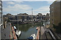
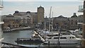
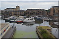
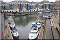
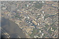
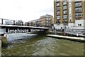
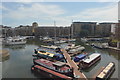
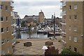
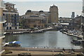
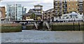
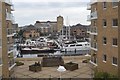
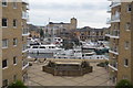
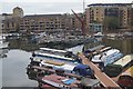
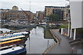
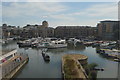
The Limehouse Basin provides a navigable link between the Regent's Canal and the River Thames, through the Limehouse Basin Lock. A basin in the north of Mile End, near Victoria Park connects with the Hertford Union Canal leading to the River Lee Navigation. The dock originally covered an area of about 15 acres. The Basin lies between the Docklands Light Railway (DLR) line and historic Narrow Street. Directly to the east is a small park, Ropemaker's Fields.
Wikipedia: Link
Wikipedia: Link
by N Chadwick
More nearby...
- Nelson (Doubletree Docklands) Pier
- Canary Wharf Pier
- The Pumphouse Museum & Lavender Nature Park
- Turfgame
- B205 Road
- National Network Cycle Route 425
- Russia Dock Woodland
- Canary Wharf
- Blacksmith's Pubs
- Hilton Hotels and Resorts
- Surrey Commercial Docks
- Thames Clipper (Uber Boats)
- Docklands Light Railway (DLR)
- Thames Sailing Barges
- River Thames
- Thames Path
- Fullers Brewers and pubs
- Regent's Canal
- One Canada Square, Canary Wharf
- Narrowboats
- K2 & K6 Telephone Boxes
- Listed Buildings and Structures
- Royal Victoria DLR Station
By N Chadwick. Used on 21 images
- Lea Navigation (Lee Navigation)
By N Chadwick. Used on 427 images
- Regent's Canal
By Oast House Archive. Used on 641 images
- Stratford High Street Station
By N Chadwick. Used on 1 images
- Docklands Light Railway (DLR)
By N Chadwick. Used on 209 images
- Prince Regent DLR Station
By N Chadwick. Used on 8 images
- Limehouse Stations
By N Chadwick. Used on 6 images
15 images use this description:
- View all images using this description in the Browser | On a Map
- View all images using "Limehouse Basin" Shared Description(s) | (Just this shared description)
- This description is located in TQ3680,
 Links for TQ3680 | Photos for TQ3680
 - Find nearby images mentioning the words [ Limehouse Basin ] | (in the Browser)
These Shared Descriptions are common to multiple images. For example, you can create a generic description for an object shown in a photo, and reuse the description on all photos of the object. All descriptions are public and shared between contributors, i.e. you can reuse a description created by others, just as they can use yours.
Created: Sun, 31 Jan 2016, Updated: Sun, 31 Jan 2016
The 'Shared Description' text on this page is Copyright 2016 N Chadwick, however it is specifically licensed so that contributors can reuse it on their own images without restriction.