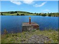
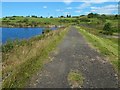
Whinhill Reservoir :: Shared Description
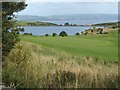
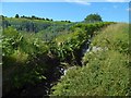
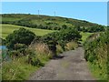
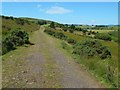
Whinhill Reservoir is alongside the course of Greenock Whinhill Golf Club, but it is accessible by means of footpaths.
In the 1790s, a dam was built here on the Carts Burn for the Cartsdyke Mill Company. Though referred to as the Whin Hill Dam or Whinhill Dam, it was known more colloquially as Beath's Dam (sometimes spelled Beith's Dam), after the miller who owned it.
Its banks gave way on the 15th of March 1815. The breach was not repaired until 1821. The dam was later purchased by Shaws Water Company (see Link for more on Shaws Water Works).
The dam collapsed again on the 21st of November 1835, flooding the eastern extremity of Greenock, and a part of neighbouring Cartsdyke (which was then a separate village, not yet part of Greenock). The flood, sweeping trees along with it, destroyed a substantial bridge over the burn, near Cartsburn House. Nearly 40 people were killed by the inundation, the majority of them children (the flood occurred shortly after 11pm, when many people were in their beds).
The following account of the floods is from the Ordnance Gazetteer of Scotland (1884): "in 1815 the dam of a reservoir built in 1796 to drive the machinery of the Cartsburn Cotton Spinning Company burst, but without serious results(*). It was restored in 1821, and in 1825(*) the reservoir was taken over by the Shaws Water Company. In November 1835, an unhappy accident occurred. There had been an unusually heavy rainfall, reaching 3½ inches in 48 hours, unparalleled even in Greenock. About eleven at night the dam burst, rushing down the gorge of the Cartsburn to the town, and besides destroying much property, causing a loss of thirty-eight lives".
(*) The Spectator, in its issue of 28th November 1835, differs in some particulars: following its detailed account of the 1835 flood (which the article acknowledges as being based on an account given in the Greenock Advertiser), it states that "in the spring of 1815, the banks of this reservoir gave way, and considerable damage to property was done in very nearly the same track. The breach was not filled up until 1821; when the reservoir was judicially inspected, and found to be safe. In 1829 it was purchased by the Shaws Water Company, to increase the supply of water for the town of Greenock".
The embankment is said to have been of poor construction, and it is thought to have been further weakened by the tunnelling activities of vermin; this led to its being rapidly washed away at the start of the flood (G M Binnie, "Early Dam Builders in Britain"): see the discussion at Link (Greenock Telegraph).
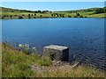
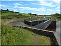
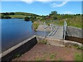
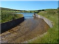
An aqueduct from the north-eastern corner of the reservoir leads ESE. At the lower end of the aqueduct, at NS28177456, water flows into it from a smaller reservoir that is centred on NS28117454; the first-edition map (surveyed in 1857) labels it "Reservoir (Shaws Waterworks)".
Below that point, the watercourse, following a natural channel through Auchmountain Glen, is called the Carts Burn; it is shown as the "Kar Burn" on Blaeu's 1654 map of Renfrewshire (see Link at NLS); the earlier manuscript map Pont 33 (c.15831596; see Link at NLS) shows "Kartsburn", probably referring not to the burn itself but to the area that is named after it.
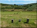
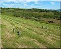
On OS maps from 1896 to at least 1938, some filter beds are shown just to the east of Whinhill Reservoir. They were centred on NS27967459, but that area is now grassed over.
A water treatment works dating from after the Second World War stands just to the north-east of the smaller reservoir, at NS28207463.
In the 1790s, a dam was built here on the Carts Burn for the Cartsdyke Mill Company. Though referred to as the Whin Hill Dam or Whinhill Dam, it was known more colloquially as Beath's Dam (sometimes spelled Beith's Dam), after the miller who owned it.
Its banks gave way on the 15th of March 1815. The breach was not repaired until 1821. The dam was later purchased by Shaws Water Company (see Link
The dam collapsed again on the 21st of November 1835, flooding the eastern extremity of Greenock, and a part of neighbouring Cartsdyke (which was then a separate village, not yet part of Greenock). The flood, sweeping trees along with it, destroyed a substantial bridge over the burn, near Cartsburn House. Nearly 40 people were killed by the inundation, the majority of them children (the flood occurred shortly after 11pm, when many people were in their beds).
The following account of the floods is from the Ordnance Gazetteer of Scotland (1884): "in 1815 the dam of a reservoir built in 1796 to drive the machinery of the Cartsburn Cotton Spinning Company burst, but without serious results(*). It was restored in 1821, and in 1825(*) the reservoir was taken over by the Shaws Water Company. In November 1835, an unhappy accident occurred. There had been an unusually heavy rainfall, reaching 3½ inches in 48 hours, unparalleled even in Greenock. About eleven at night the dam burst, rushing down the gorge of the Cartsburn to the town, and besides destroying much property, causing a loss of thirty-eight lives".
(*) The Spectator, in its issue of 28th November 1835, differs in some particulars: following its detailed account of the 1835 flood (which the article acknowledges as being based on an account given in the Greenock Advertiser), it states that "in the spring of 1815, the banks of this reservoir gave way, and considerable damage to property was done in very nearly the same track. The breach was not filled up until 1821; when the reservoir was judicially inspected, and found to be safe. In 1829 it was purchased by the Shaws Water Company, to increase the supply of water for the town of Greenock".
The embankment is said to have been of poor construction, and it is thought to have been further weakened by the tunnelling activities of vermin; this led to its being rapidly washed away at the start of the flood (G M Binnie, "Early Dam Builders in Britain"): see the discussion at Link
An aqueduct from the north-eastern corner of the reservoir leads ESE. At the lower end of the aqueduct, at NS28177456, water flows into it from a smaller reservoir that is centred on NS28117454; the first-edition map (surveyed in 1857) labels it "Reservoir (Shaws Waterworks)".
Below that point, the watercourse, following a natural channel through Auchmountain Glen, is called the Carts Burn; it is shown as the "Kar Burn" on Blaeu's 1654 map of Renfrewshire (see Link
On OS maps from 1896 to at least 1938, some filter beds are shown just to the east of Whinhill Reservoir. They were centred on NS27967459, but that area is now grassed over.
A water treatment works dating from after the Second World War stands just to the north-east of the smaller reservoir, at NS28207463.
by Lairich Rig
More nearby...
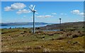
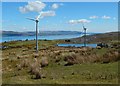
- Wind turbines, Murdieston Farm
- Murdieston trig point
- Ruin near Murdieston trig point
- Shaws Water Works
- Greenock Charcoal Works
- Broomhill Gardens & Community Hub
- Circular enclosure near Overton
- The Cut sculpture, Broomhill, Greenock
- Belville Street Mural
- Ann Street mural
- Belville Community Garden
- Dellingburn Power Station
- Delingburn Railway Bridge
- Siberia
- War Department boundary stones, Whitelees
- Radical War Memorial
- Hector McNeil House
- Duncan Street Burial Ground
- Inverkip Street Burial Ground
- Mermaid Mural, Greenock
- James Watt Memorial College
- Greenock Cemetery Gates Renovation 2017
- Greenock Bullring Car Park Steamer Murals
- Oak Mall ceramic tile mural
- Shaws Water Works
By Thomas Nugent. Used on 114 images
- Maggie's Well, Greenock
By Thomas Nugent. Used on 5 images
- Former site of Shaws
By Lairich Rig. Used on 8 images
- Greenock Charcoal Works
By Thomas Nugent. Used on 20 images
- The Cut sculpture, Broomhill, Greenock
By Thomas Nugent. Used on 3 images
- Former Free Gaelic Church, Greenock
By Thomas Nugent. Used on 9 images
- The Ardgowan Club
By Thomas Nugent. Used on 33 images
17 images use this description:
- View all images using this description in the Browser | On a Map
- View all images using "Whinhill Reservoir" Shared Description(s) | (Just this shared description)
- This description is located in NS27737459,
 Links for NS27737459 | Photos for NS27737459
 - Find nearby images mentioning the words [ Whinhill Reservoir ] | (in the Browser)
These Shared Descriptions are common to multiple images. For example, you can create a generic description for an object shown in a photo, and reuse the description on all photos of the object. All descriptions are public and shared between contributors, i.e. you can reuse a description created by others, just as they can use yours.
Created: Sat, 5 Aug 2017, Updated: Fri, 3 Nov 2017
The 'Shared Description' text on this page is Copyright 2017 Lairich Rig, however it is specifically licensed so that contributors can reuse it on their own images without restriction.