Inverclyde Windfarm :: Shared Description
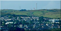
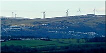
A 24MW windfarm, consisting of eight 110-metre high turbines in an area centred on NS29747254, ESE of the summit of Corlic Hill (Corlick Hill on the OS map). The developer was BayWa r.e. UK, and construction began in September 2019, ending in late 2020. The planning application had been rejected by Inverclyde Council, but was then appealed to the Scottish Government.
by Lairich Rig
More nearby...
- Possible hut circles
- The ruins of Corlick
- Hut circle
- Hut circle
- Lurg Moor Roman fortlet
- Hut circle
- Lithic working site
- Loudenward field system
- War Department boundary stones, Whitelees
- PS Comet Replica in Port Glasgow
- The ruins of Corlick
By Lairich Rig. Used on 3 images
- Reverse Vending Machines in Port Glasgow
By Thomas Nugent. Used on 2 images
- PS Comet Replica in Port Glasgow
By Thomas Nugent. Used on 59 images
- St John The Baptist RC Church, Port Glasgow
By Thomas Nugent. Used on 16 images
2 images use this description:
- View all images using "Inverclyde Windfarm" Shared Description(s) | On a Map | (Just this shared description)
- This description is located in NS297725,
 Links for NS297725 | Photos for NS297725
 - Find nearby images mentioning the words [ Inverclyde Windfarm ] | (in the Browser)
These Shared Descriptions are common to multiple images. For example, you can create a generic description for an object shown in a photo, and reuse the description on all photos of the object. All descriptions are public and shared between contributors, i.e. you can reuse a description created by others, just as they can use yours.
Created: Wed, 13 Jan 2021, Updated: Wed, 13 Jan 2021
The 'Shared Description' text on this page is Copyright 2021 Lairich Rig, however it is specifically licensed so that contributors can reuse it on their own images without restriction.