
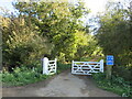
|
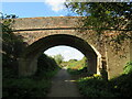
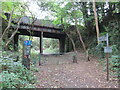
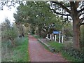
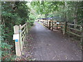
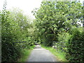
Former railway junction, Wetherby
by Malc McDonald
geograph for square SE3948
The site of a former railway junction in Wetherby. The railway closed in 1964.... (more)
|
|
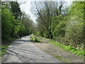
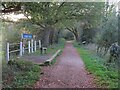
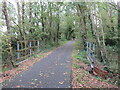
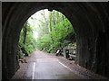
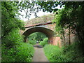
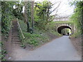
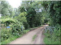
Red Squirrel Trail near Merstone
by Malc McDonald
geograph for square SZ5384
The Red Squirrel Trail passing under a bridge near Merstone. The bridge is a... (more)
|
|
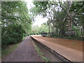
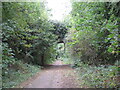
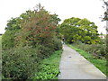
Brampton Valley Way near Chapel Brampton
by Malc McDonald
geograph for square SP7367
The Brampton Valley Way crossing a former railway viaduct in Northamptonshire.... (more)
|
|
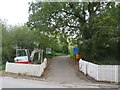
Flitch Way, near Great Dunmow
by Malc McDonald
geograph for square TL5921
Here, the Flitch Way bends sharply to the right, so that it can cross the road... (more)
|
|
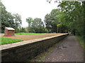
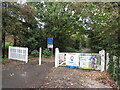
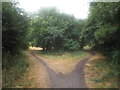
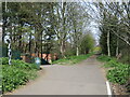
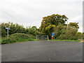
Former railway junction, Wetherby
by Malc McDonald
geograph for square SE3949
The site of a railway junction on the outskirts of Wetherby, in West Yorkshire.... (more)
|
|
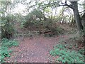
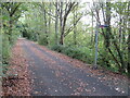
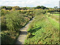
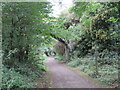
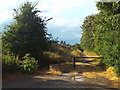
Dismantled railway, Wetherby
by Malc McDonald
geograph for square SE3948
This wooded cutting in the town of Wetherby was part of a railway route, until... (more)
|
|
Former railway junction, Whitby
by Malc McDonald
geograph for square NZ8910
The site of Prospect Hill junction in Whitby. The path to the right is the... (more)
|
|
Larpool Viaduct, near Whitby
by Malc McDonald
geograph for square NZ8909
Larpool viaduct, built to carry a railway line into Whitby, now forms part of... (more)
|
|
Winscombe former railway station
by Malc McDonald
geograph for square ST4157
The Strawberry Line path passing through the former railway station at Winscombe... (more)
|
|
Winscombe former railway station
by Malc McDonald
geograph for square ST4157
The Strawberry Line path passing through the former railway station at Winscombe... (more)
|
|
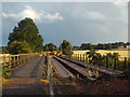
Brampton Valley Way, near Brixworth
by Malc McDonald
geograph for square SP7368
In this image, a bridge carries Brampton Valley Way across a stream.
The... (more)
|
|
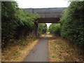
Bridge over Brampton Valley Way near Brixworth
by Malc McDonald
geograph for square SP7371
A bridge carrying a road over Brampton Valley Way. The bridge would have been... (more)
|
|
Site of Brixworth railway station
by Malc McDonald
geograph for square SP7371
It's hard to tell from the image, but a railway station once stood here.... (more)
|
|
Stane Street Halt, Flitch Way, near Bishop's Stortford
by Malc McDonald
geograph for square TL5421
Stane Street Halt was an intermediate stop on the railway line linking... (more)
|
|
Stane Street Halt, Flitch Way, near Bishop's Stortford
by Malc McDonald
geograph for square TL5421
Stane Street Halt was an intermediate stop on the railway line linking... (more)
|
|
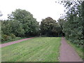
Former railway path, Wetherby
by Malc McDonald
geograph for square SE3949
A former railway route on the outskirts of Wetherby. The line closed in 1964.... (more)
|
|
Red Squirrel Trail, Cowes
by Malc McDonald
geograph for square SZ4994
The Red Squirrel Trail joining the route of a dismantled railway, which it will... (more)
|
|
Red Squirrel Trail near Cowes
by Malc McDonald
geograph for square SZ5093
The Red Squirrel Trail near Cowes. Here the trail follows a disused railway... (more)
|
|
Red Squirrel Trail near Cowes
by Malc McDonald
geograph for square SZ5093
The Red Squirrel Trail near Cowes on the Isle of Wight. Here, the trail follows... (more)
|
|
Red Squirrel Trail near Cowes
by Malc McDonald
geograph for square SZ5092
The Red Squirrel Trail following a dismantled railway from Cowes to Newport.... (more)
|
|
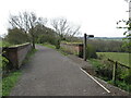
Red Squirrel Trail near Newport
by Malc McDonald
geograph for square SZ5090
The Red Squirrel Trail follows a former railway route along the western bank of... (more)
|
|
Red Squirrel Trail and NCN23, Newport
by Malc McDonald
geograph for square SZ5090
As the Red Squirrel Trail leaves Newport, it joins a former railway route to... (more)
|
|
Red Squirrel Trail near Merstone
by Malc McDonald
geograph for square SZ5284
A view of the Red Squirrel Trail as it passes along a former railway near... (more)
|
|
Red Squirrel Trail near Merstone
by Malc McDonald
geograph for square SZ5285
This section of the Red Squirrel Trail follows a former railway which closed in... (more)
|
|
Red Squirrel Trail near Newport
by Malc McDonald
geograph for square SZ5085
A view of the Red Squirrel Trail south of Newport on the Isle of Wight. This... (more)
|
|
Strawberry Line path at Winscombe
by Malc McDonald
geograph for square ST4157
The Strawberry Line path at Winscombe in Somerset. The path forms part of... (more)
|
|
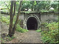
Former railway tunnel near Winscombe
by Malc McDonald
geograph for square ST4256
The Strawberry Line path emerging from a former railway tunnel near Winscombe in... (more)
|
|
Strawberry Line path, Cheddar
by Malc McDonald
geograph for square ST4553
A narrow section of the Strawberry Line path along the side of an industrial... (more)
|
|
Site of Lamport railway station
by Malc McDonald
geograph for square SP7575
Brampton Valley Way at the site of Lamport railway station. The station closed... (more)
|
|
Brampton Valley Way at Lamport station site
by Malc McDonald
geograph for square SP7575
Brampton Valley Way at the site of Lamport station. The station closed in 1960.... (more)
|
|
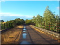
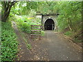
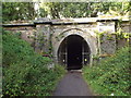
Kelmarsh Tunnel, south portal
by Malc McDonald
geograph for square SP7579
Brampton Valley Way approaching the south portal of Kelmarsh Tunnel.
Kelmarsh... (more)
|
|
Brampton Valley Way approaching Kelmarsh Tunnel
by Malc McDonald
geograph for square SP7479
Kelmarsh Tunnel is one of two tunnels on the Brampton Valley Way. Both tunnels... (more)
|
|
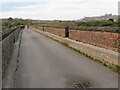
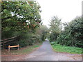
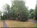
Site of Ryhope railway station
by Malc McDonald
geograph for square NZ4152
This image was taken on the site of Ryhope railway station. The footbridge is... (more)
|
|
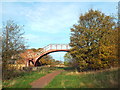
Mawddach Trail near Barmouth
by Malc McDonald
geograph for square SH6314
The Mawddach Trail is on the route of the Cross Britain Way. Here, a bridge... (more)
|

|
Flitch Way, near Bishop's Stortford
by Malc McDonald
geograph for square TL5421
Flitch Way follows the course of a dismantled railway, using a former railway... (more)
|
|
Downs Link, near Cranleigh
by Malc McDonald
geograph for square TQ0439
The Downs Link path follows a dismantled railway line for most of its length.... (more)
|
|
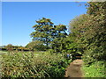
Former railway path, Wetherby
by Malc McDonald
geograph for square SE4048
A path along the route of a dismantled railway in Wetherby, in West Yorkshire.... (more)
|
|
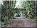
Bridge over dismantled railway, Wetherby
by Malc McDonald
geograph for square SE3948
This wooded cutting in Wetherby is the route of a railway which closed in 1964.... (more)
|
|
Cinder Track, Whitby
by Malc McDonald
geograph for square NZ8910
The Cinder Track path follows the route of a dismantled railway between... (more)
|
|
Former railway path, Whitby
by Malc McDonald
geograph for square NZ8910
This path, on the route of a former railway line, forms part of the Cinder Track... (more)
|
|
Cinder Track near Whitby
by Malc McDonald
geograph for square NZ8909
The Cinder Track follows the route of a former railway between Whitby and... (more)
|
|
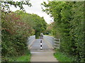
Bridge on the Red Squirrel Trail near Newport
by Malc McDonald
geograph for square SZ5091
The Red Squirrel Trail crossing an inlet between Cowes and Newport. Here, the... (more)
|
|
Red Squirrel Trail near Newport
by Malc McDonald
geograph for square SZ5090
The Red Squirrel Trail at its junction with Dodnor Lane, north of Newport.... (more)
|
|
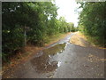
Old railway path near South Cerney
by Malc McDonald
geograph for square SU0696
A shared path for walking and cycling, near South Cerney in Gloucestershire.... (more)
|
|
Site of Kelmarsh railway station
by Malc McDonald
geograph for square SP7480
Kelmarsh was one of six railway stations on the route between Northampton and... (more)
|
|
Site of Clipston & Oxendon railway station
by Malc McDonald
geograph for square SP7382
There is little if anything in this view to suggest that a railway station once... (more)
|
|
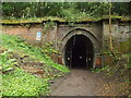
Oxendon tunnel, south portal
by Malc McDonald
geograph for square SP7383
Oxendon Tunnel is one of two tunnels on the Brampton Valley Way. Both tunnels... (more)
|
|
Oxendon Tunnel, north portal
by Malc McDonald
geograph for square SP7383
Oxendon Tunnel is one of two tunnels on the Brampton Valley Way. Both tunnels... (more)
|
|
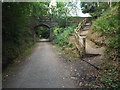
Forest Way, Forest Row
by Malc McDonald
geograph for square TQ4334
Forest Way, passing through Forest Row in East Sussex. The bridge was built to... (more)
|
|
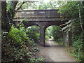
Bridge over Forest Way, Forest Row
by Malc McDonald
geograph for square TQ4334
This bridge was built to carry a minor road across a railway line. The railway... (more)
|