Public Tags
Tag: Building·Foundations
Showing images tagged with Building Foundations tag.
|
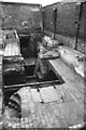
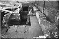
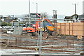
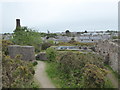
Smethwick Engine foundations
by Chris Allen for square SP0288 The Smethwick Engine foundations
This is a view of the open air excavation of... (more)
Tags:
Beam Engine HouseX
Boulton & WattX
Building Foundations
type:Close LookX
FoundationsX
subject:Historic BuildingX
top:Historic Sites and ArtefactsX
place:SmethwickX
|
|
The Smethwick Engine foundations
by Chris Allen for square SP0288 This is a view of the open air excavation of the foundations of a 1779 Boulton... (more)
Tags:
Beam Engine HouseX
Building Foundations
type:Close LookX
FoundationsX
subject:Historic BuildingX
top:Historic Sites and ArtefactsX
place:SmethwickX
|
|
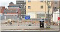
Nos 123-137 York Street, Belfast - May 2018(2)
by Albert Bridge geograph for square J3375 The view from Little Patrick Street at an early stage of work on the... (more)
Tags:
place:BelfastX
Building Foundations
top:Construction, DevelopmentX
FoundationsX
type:GeographX
top:Housing, DwellingsX
Student AccommodationX
|
|
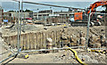
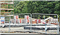
New supermarket, Sandy Row, Belfast - October 2014(2)
by Albert Bridge geograph for square J3373 The foundations for the new building. Sandy Row and the former Ulster Brewery... (more)
|
|
New supermarket, Sandy Row, Belfast - October 2014(1)
by Albert Bridge geograph for square J3373 The foundations for the new building. Wellwood Street and Gt Victoria Street... (more)
|
|
New foundations, Hollins Mill Lane
by Stephen Craven geograph for square SE0523 Not much is left of the former Puzzle Hall Inn SE0523 : Puzzle Hall Inn - Hollins Mill Lane, Sowerby Bridge and immediately to the... (more)
|
|
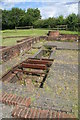
Foundations for a new building on the moors
by Stephen Craven geograph for square SE1543 I presume the new building here was to be associated with the "pump... (more)
|
|
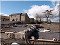
Old and new at Littlewood Farm
by Trevor Littlewood geograph for square NY9237 A curious situation here where the foundations of the new build in front of the... (more)
|
|
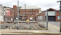
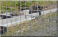
"The Front" site, Holywood (March 2017)
by Albert Bridge geograph for square J3979 Work underway on the foundations.
Tags:
Apartments Under ConstructionX
Building Foundations
subject:ConstructionX
Construction SiteX
top:Construction, DevelopmentX
FoundationsX
type:GeographX
place:HolywoodX
|
|
Foundations for Swannington Incline winding engine
by Chris Allen geograph for square SK4215 The Swannington Incline was the work of Robert Stephenson and was cable worked... (more)
|
|
Erudition in Action - by Ashted locks and tunnel.
by Chris Allen for square SP0887 In 1813 the Birmingham Canal Navigation Company bought a steam pumping engine... (more)
Tags:
Beam EngineX
place:BirminghamX
Building Foundations
CanalX
top:CanalsX
Engine HouseX
Newcomen SocietyX
top:People, EventsX
|
|
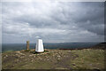
Summit area of Carlton Moor
by Trevor Littlewood geograph for square NZ5102 The summit area of Carlton Moor is clearly well-frequented: it's crossed by... (more)
Tags:
Boundary StoneX
top:Boundary, BarrierX
Building Foundations
type:GeographX
Hill Summit AreaX
top:Historic Sites and ArtefactsX
PathX
top:PathsX
subject:SummitX
Trig PointX
top:UplandsX
|
|
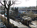
Bickford's and Palmer's Shafts, South Crofty
by Chris Allen geograph for square SW6641 Tucked away on the Heartlands site is a circular structure that I am stood on,... (more)
Tags:
former:Boiler HouseX
Building Foundations
ChimneyX
top:Derelict, DisusedX
type:GeographX
top:Historic Sites and ArtefactsX
subject:MineX
top:Quarrying, MiningX
place:South CroftyX
top:Water ResourcesX
|
|
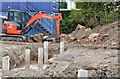
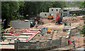
Park Villas, Dundonald - July 2017(2)
by Albert Bridge geograph for square J4173 Foundations work at the middle of the site.
Tags:
Building Foundations
subject:ConstructionX
top:Construction, DevelopmentX
place:Dundonald (Co Down)X
type:GeographX
Houses Under ConstructionX
top:Housing, DwellingsX
|
|
"Palmerston" housing site, Belfast (2013-2)
by Albert Bridge geograph for square J3775 The view, through the Palmerston Road fence, showing the early stage of work on... (more)
|
|
Vacant development site, Lisburn (2013-2)
by Albert Bridge for square J2763 See J2763 : Vacant development site, Lisburn (2013-1). Foundations beside the Ballynahinch Road. There are other... (more)
|
|
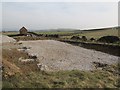
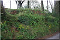
Roadside bank on south side of Stonebarrow Lane
by Roger Templeman geograph for square SY3793 On top of the bank are the foundations of a hut (wartime?) on which there is an... (more)
|
|
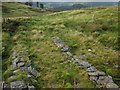
Bases of buildings near to car park
by Trevor Littlewood geograph for square SO0224 A minor road climbs high on the northern slopes of Pen y Fan to reach a car park... (more)
|
|
Building site, Upton
by Derek Harper geograph for square SX9065 Preparations continue for dwellings to be built on the site shown in SX9065 : Demolishing the Dairy Crest depot.
|
|
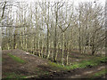
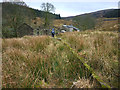
Site of building by Glyndwr's Way
by Derek Harper geograph for square SN7499 Rows of slates, surrounded by a fence, alongside the byway followed by Glyndwr's Way.
Tags:
Access LandX
Building Foundations
top:Historic Sites and ArtefactsX
top:MoorlandX
MoorlandX
top:UplandsX
|
|
Did the navvies live here when they built the railway?
by Karl and Ali geograph for square SD7784 It took thousands of 'navvies' to build the Settle - Carlisle line in... (more)
|