|
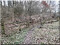
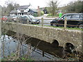
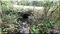
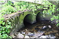
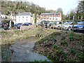
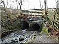
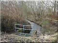
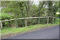
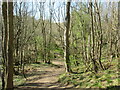
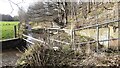
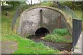
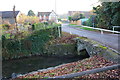
Footbridge and culvert by the M1
by Ian Calderwood
geograph for square SK4563
A stream emerges from a culvert under the M1, where it is crossed by a... (more)
|
|
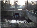
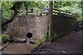
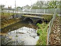
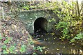
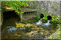
Culvert under Mill Lane, Westerham
by Malc McDonald
geograph for square TQ4453
A culvert under Mill Lane, in Westerham.
The footbridge to the right of this... (more)
|
|
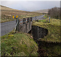
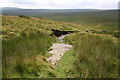
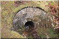
Culvert, Spelga
by Rossographer
geograph for square J2627
A stream running off Slievenamuck which has been culverted under the Spelga Pass... (more)
|
|
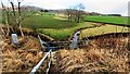
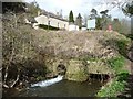
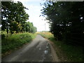
Bar Road crossing Sandyford Brook
by Ian Calderwood
geograph for square SK2774
Bar Road used to be the main road from Baslow to Chesterfield.
|
|
Pond and Culverts by Aylesbury Road, Mobwell
by David Hillas
geograph for square SP8902
This photo shows the culverts under Aylesbury Road where water from the pond to... (more)
|
|
Looking through pipe taking stream under road west of Eye Kettleby
by Roger Templeman
for square SK7216
|
|
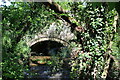
Culvert on Clawdd Brook
by M J Roscoe
geograph for square SO3509
Stream leaving culvert after flowing from Clytha Park under road.
|
|
Culvert under Rendham Road
by Geographer
for square TM3667
|
|
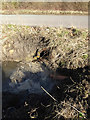
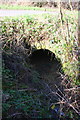
Dried up culvert entrance
by yorkshirelad
for square SE1619
The stream for the culvert under Keldergate is dry during the dry/hot spell of Summer 2022
|
|
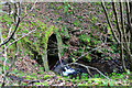
Culvert discharge
by David Lally
geograph for square SK5311
The small steam that runs through the southern end of Swithland Wood exits said... (more)
|
|
Culvert for stream under Hoby Road SE of Sandlands Farm
by Roger Templeman
geograph for square SK6918
Ordnance Survey records indicate that a rivet benchmark levelled at 62.548m... (more)
|
|
Culvert entrance at Chester le Street
by Robert Graham
geograph for square NZ2751
This carries the Chester Burn under the market Place in the town centre at North... (more)
|
|
Culvert taking Bellerby Beck under South Moor Road
by Roger Templeman
for square SE1392
|
|
Exposed culvert
by Malcolm Neal
geograph for square SK3436
The culvert visible on the left side of the picture carries the Markeaton Brook... (more)
|
|
Culvert under Brompton Lane for field drain at Redhill Bank
by Roger Templeman
for square SE3697
|
|
Culvert for stream under A684 near Collier Holme
by Roger Templeman
geograph for square SD8392
There is an Ordnance Survey cut mark benchmark... (more)
|
|
Culverted Thames & Severn Canal, Chalford
by Christine Johnstone
geograph for square SO8902
Bell Lock was approximately under the car park.
|
|
Streams on north side of A66 approaching culvert under the A66
by Luke Shaw
geograph for square NY7815
|
|
Drainage culvert
by David Pashley
for square TF9104
|
|
Culvert taking field ditch under Sproxton Road
by Luke Shaw
geograph for square SK8623
|
|
Saxby Road passing entrance to industrial estate
by Phil Richards
geograph for square SK7619
Ordnance Survey documents indicate that in 1983 a rivet benchmark was levelled... (more)
|
|
Stormwater Bridge, on the B5289
by Christine Johnstone
geograph for square NY2523
Seven culverts can carry floodwater under the embankment.
|
|
Culvert for stream under Church Road
by Roger Templeman
geograph for square SP3813
|
|
The Capelrig Burn emerges
by Richard Sutcliffe
geograph for square NS5256
The burn exits a large double culvert, having just passed under Barrhead Road.
|
|
Capelrig Burn
by Richard Sutcliffe
geograph for square NS5256
About to enter a culvert and flow under Westacres Road.
|
|
Culvert in wall on south side of A684
by Roger Templeman
for square SD9889
|
|
Craigdhu Burn
by Richard Sutcliffe
geograph for square NS5474
The burn enters a double culvert to go under Prestonfield.
|
|
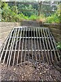
Gas bottles blocking a culvert
by Ian S
geograph for square TF4982
At the junction of North Road and Mile Lane.
|
|
Culvert for minor road over stream west of Crosby Manor
by Roger Templeman
geograph for square SE4091
|
|
Culvert for stream under B6255 at East Pasture
by Roger Templeman
geograph for square SD8085
|
|
Culvert for stream under road at Tollbrook Corner
by Roger Templeman
geograph for square SP5118
|
|
Brick culvert for Trunk Ditch
by Roger Templeman
geograph for square SU6285
|
|
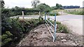
Culvert bringing water under the B1255 at Danes Dyke
by Martin Dawes
geograph for square TA2170
At the bottom of this woodland path
|
|
Culvert in the Tweed Bridge, Innerleithen
by Jim Barton
geograph for square NT3336
A stone-arch culvert for a ditch bordering Toll Wood close to the Tweed.
|
|
Culvert taking Mould Gill under B6270 at Birkdale Common
by Roger Templeman
geograph for square NY8202
|
|
The Thames & Severn Canal, culverted
by Christine Johnstone
geograph for square SO8802
The canal has been infilled where a minor road crosses.
|
|
Stream emerging from culvert on south side of A66
by Luke Shaw
geograph for square NY7815
|
|
Low Road passing Hamilton House
by Martin Dawes
geograph for square TM3262
The white posts either side of the road mark the field drain culvert, the end of... (more)
|
|
Culvert for the Silver Burn
by Jim Barton
for square NT2159
A small stone arch where the A766 crosses the burn close to the Talla aqueduct.
|
|
Benchmark on culvert top near Crosby Manor
by Roger Templeman
for square SE4091
Ordnance Survey rivet benchmark described on the Bench Mark Database at... (more)
|
|
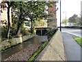
Braid Burn beneath Comiston Road, Edinburgh
by Jim Barton
geograph for square NT2470
A substantial stone portal for the culvert taking the burn through to the... (more)
|
|
Benchmark on drain culvert Brompton Lane
by Roger Templeman
for square SE3697
Ordnance Survey rivet benchmark described on the Bench Mark Database at... (more)
|
|
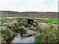
Stone culvert for the Quarry Burn
by Jim Barton
for square NU2003
The burn issues from this stone arch below the hairpin bend near Guyzance.
|
|
Benchmark on culvert in south face of wall on south side of A684
by Roger Templeman
for square SD9889
Ordnance Survey cut mark benchmark described on the Bench Mark Database at... (more)
|
|
Ginge Brook under Stocks Lane
by Roger Templeman
geograph for square SU4691
There was an Ordnance Survey benchmark, Link ,... ( more) |
|
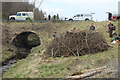
Otter holt by the Afon Lwyd, Garn Lakes LNR
by M J Roscoe
geograph for square SO2309
Holt constructed by Gwent Wildlife Trust working party, with some guidance from... (more)
|
|
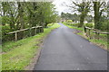
View east along minor road passing Crosby Manor on the right
by Roger Templeman
geograph for square SE4091
|
|
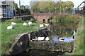
Ducks on canal at Two Locks Road, Cwmbran
by M J Roscoe
geograph for square ST2994
Ducks at the top end of a former lock on a disused section of the canal.
|
|
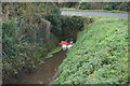
Stream, Abbotskerswell
by Derek Harper
geograph for square SX8568
|