Geograph - photograph every grid square
About tags on Geograph
Tags
Geographical Context
Subjects
Types
Other Prefixes
Public Tags
Related Tags
|
Coverage Map
Tag:
Oil·Platform
Showing images tagged with
Oil Platform
tag.
View all tagged images
-
In Browser
Search within these images
:
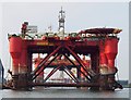
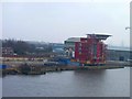
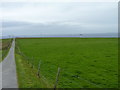
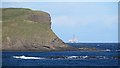
Three rigs at Belfast
by
Rossographer
for square
J3676
A view along Ship Repair Quay with the Building Dock in the distance behind.... (
more
)
Tags:
place:
Belfast
X
place:
Belfast Docks
X
Belfast Docks
X
top:
City, Town Centre
X
top:
Coastal
X
top:
Docks, Harbours
X
Harland & Wolff
X
Harland and Wolff
X
top:
Industry
X
Oil Platform
subject:
Oil Rig
X
Oil Rig
X
Ship Building Yard
X
Ship Repair
X
Ship Repair Quay
X
Ship Repairers
X
Shipping
X
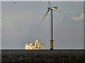
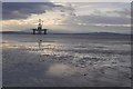
Oil platform and wind turbine
by
Gerald England
for square
SJ0392
The oil platform just beyond the wind farm in Liverpool Bay is clearly visible... (
more
)
Tags:
top:
Energy Infrastructure
X
Oil Platform
Wind Turbine
X
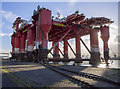
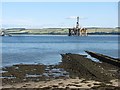
The 'Borgholm Dolphin' at Belfast
by
Rossographer
geograph for square
J3676
The accommodation platform 'Borgholm Dolphin'... (
more
)
Tags:
place:
Belfast
X
Belfast Docks
X
Belfast Harbour
X
Borgholm Dolphin
X
top:
City, Town Centre
X
top:
Coastal
X
top:
Docks, Harbours
X
type:
Geograph
X
top:
Industry
X
subject:
Offshore Installation
X
Oil Industry
X
Oil Platform
Oil Rig
X
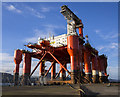
Oil platform
by
James Allan
geograph for square
NZ3567
Offshore oil platform onshore for maintenance.
Tags:
top:
Docks, Harbours
X
top:
Energy Infrastructure
X
top:
Estuary, Marine
X
top:
Industry
X
place:
North Shields
X
Oil Platform
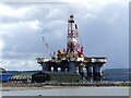
Ocean Valiant rig at Invergordon
by
Marika Reinholds
for square
NH7068
The rig was built in 1988 in South Korea and has worked in the Brent oil field... (
more
)
Tags:
top:
City, Town Centre
X
top:
Coastal
X
type:
Cross Grid
X
top:
Estuary, Marine
X
top:
Industry
X
place:
Invergordon
X
Ocean Valiant
X
Oil Platform
Oil Rig
X
subject:
Oil Rig
X
Oil Rigs in Dock at Invergordon
X
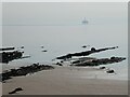
Coastal rocks at Lower Largo
by
Oliver Dixon
geograph for square
NO4102
Oil platform out to sea.
Tags:
Beach
X
top:
Coastal
X
Coastal Rocks
X
type:
Geograph
X
Oil Platform
top:
Quarrying, Mining
X
subject:
Rock
X
top:
Rocks, Scree, Cliffs
X
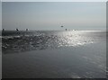
Figures on the beach
by
Oliver Dixon
geograph for square
NO4001
Lundin Links beach. With an oil platform out in the Firth.
Tags:
Beach
X
subject:
Beach
X
top:
Coastal
X
type:
Geograph
X
Oil Platform
top:
Quarrying, Mining
X
Narrow road to Scapa Flow
by
James Allan
geograph for square
HY4107
Looking from Calderhead down to the bay with oil platforms moored there.
Tags:
top:
Coastal
X
top:
Docks, Harbours
X
type:
Geograph
X
top:
Grassland
X
top:
Lowlands
X
Oil Platform
Orkney
X
subject:
Road
X
place:
Scapa Flow
X
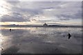
Burntisland sands and Paragon MSS1
by
Richard Webb
geograph for square
NT2485
View towards the Pentland Hills beyond Paragon MSS1, one of the many oil... (
more
)
Tags:
Beach
X
top:
Coastal
X
top:
Energy Infrastructure
X
type:
Geograph
X
Intertidal
X
Oil Platform
Semisubmersible Rig
X
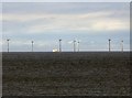
Wind Farms from Llandudno
by
Gerald England
for square
SH7882
The nearer turbines
SJ0392 : Oil platform and wind turbine
are probably around
SJ0392
. The oil platform... (
more
)
Tags:
top:
Energy Infrastructure
X
Oil Platform
Wind Farm
X
Wind Turbines
X
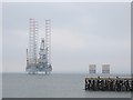
Prospector 1
by
Richard Webb
for square
NH7867
A new jack up rig (built in China in 2013) anchored off the Nigg yard. View from Cromarty.
Tags:
top:
Estuary, Marine
X
Oil Platform
Winter sunshine off Burntisland
by
Richard Webb
geograph for square
NT2486
Looking over the rapidly flooding sands towards Paragon MSS1, a semisubmersible rig.
Tags:
Beach
X
top:
Coastal
X
top:
Energy Infrastructure
X
type:
Geograph
X
Intertidal
X
Oil Platform
Semisubmersible Rig
X
Castle Point and Lions Head
by
Richard Webb
for square
NJ8366
Crags on the north coast of Aberdeenshire near Pennan.
Tags:
Crags
X
Headland
X
Oil Platform
top:
Rocks, Scree, Cliffs
X
Pipelines, Invergordon
by
Richard Webb
geograph for square
NH7169
A pair of pipes running into the Cromarty Firth.
Tags:
Beach
X
top:
Coastal
X
Oil Platform
Pipes
X
Paragon MSS1
by
Richard Webb
geograph for square
NT2485
A rig being stored off Burntisland. In the sands there are the stumps of poles... (
more
)
Tags:
p150 hill:
Arthurs Seat
X
Beach
X
top:
Coastal
X
top:
Defence, Military
X
top:
Derelict, Disused
X
top:
Energy Infrastructure
X
type:
Geograph
X
Intertidal
X
Oil Platform
Semisubmersible Rig
X
WW2 Anti-Glider Posts
X
Burntisland sands
by
Richard Webb
geograph for square
NT2485
A view towards Edinburgh, Black Rocks and the semisubmersible rig Paragon MSS1... (
more
)
Tags:
p150 hill:
Arthurs Seat
X
Beach
X
top:
Coastal
X
top:
Energy Infrastructure
X
type:
Geograph
X
Intertidal
X
Oil Platform
Semisubmersible Rig
X
Skerries
X
View more in the Image Search
or
in Browser
View images matching 'Oil Platform' anywhere
in
the tags
Don't click these:
PotMel 1
PotMel 2
☰
Home
View
Search
Marked Images
Maps
Browser
Explore
Showcase
New Images
Collections
Interact
Games
Discussions
Blog
Contributors
Submit
Statistics
Leaderboards
General
FAQ
Help Pages
Sitemap
Contact Us
Support Us
sponsored by
🔍
What to search:
Photos
Enter keywords or a location/postcode to search nearby images
Enter a Grid Reference
Placenames
Collections
Website Pages
Everything
Others:
Advanced Search
|
Image Browser
Or:
Coverage Map
|
Searchable Map
You are not logged in
login
|
register