Public Tags
Showing latest 50 of 89 images tagged with place:Inishmore tag.
|
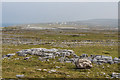
Approaching Dún Aonghasa on Inishmore
by Jeff Buck geograph for square L8209 Approaching the prehistoric hill fort of Dún Aonghasa on Inishmore.
Wikipedia... (more)
Tags:
Aran IslandsX
place:Aran IslandsX
place:GalwayX
type:GeographX
Hill FortX
top:Historic Sites and ArtefactsX
place:Inishmore
top:IslandsX
Prehistoric Hill FortX
country:Republic of IrelandX
|

|
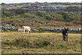
Inishmore Donkey
by Jeff Buck geograph for square L8112 Taken in the village of Eoghanacht next to the monastic ruins of Na Seacht... (more)
Tags:
place:Aran IslandsX
Aran IslandsX
DonkeyX
place:EoghanachtX
type:GeographX
place:Inishmore
top:IslandsX
|
|
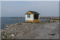
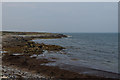
Seal watching point
by Ian Capper geograph for square L8511 The bay at Port Chorruch is advertised as the place for watching seals, and this... (more)
|

|
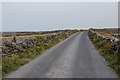
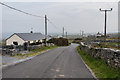
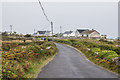
Coastal road
by Ian Capper geograph for square L8511 The road that runs along the north coast of Inishmore, a quieter (and easier)... (more)
|
|
Towards Port Chorruch
by Ian Capper geograph for square L8511 Looking towards Port Chorruch from the road that follows the north coast of Inishmore.
|
|
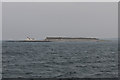
Oileán an Tuí
by Ian Capper geograph for square L9008 Island guarding the entrance to Killeany Bay on Inis Mór/Inishmore. The... (more)
Tags:
place:Inis MorX
place:Inishmore
top:IslandsX
LighthouseX
National Inventory of Architectural HeritageX
NIAHX
place:Oilean an TuiX
place:Straw IslandX
|
|
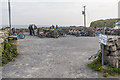
Bicycle park
by Ian Capper geograph for square L8210 Most tourist attractions have a large car park. But the lack of tourist cars on... (more)
Tags:
Bicycle ParkX
place:Cill MhuirbhighX
place:Inis MorX
place:Inishmore
top:IslandsX
place:KilmurvyX
top:Roads, Road TransportX
|
|
Port na Mainistrach
by Ian Capper geograph for square L8710 Bay on the north coast of Inishmore.
|
|
Aran recycling centre
by Ian Capper geograph for square L8610 Inishmore's recycling centre, situated on the road that runs along the... (more)
|
|
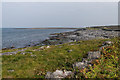
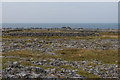
Rough fields
by Ian Capper geograph for square L8411 Rough fields on the coastal flats on the north side of Inishmore.
|
|
Coastal road
by Ian Capper geograph for square L8410 The road that runs along the north coast of Inishmore, a quieter (and easier)... (more)
|
|
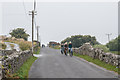
Oghil/Eochaill
by Ian Capper geograph for square L8610 The "main" road across Inishmore in Oghil/Eochaill townland. Cycling... (more)
|
|
Oghil/Eochaill
by Ian Capper geograph for square L8709 The "main" road across Inishmore in Oghil/Eochaill townland.
|
|
Track to Port Eochla
by Ian Capper geograph for square L8610 Grass track leading to a bay on the north coast of Inishmore.
|
|
Black and white
by Ian Capper geograph for square L8410 A black donkey and a white cow with its calf in a field off the north coastal... (more)
|
|
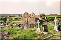
Saint Enda's Church, Inishmore
by Jeff Buck geograph for square L8906 Also known as Saint Enda's Monastery, the ancient ruined church of St Enda... (more)
Tags:
place:Aran IslandsX
CemeteryX
Church (Ruined)X
place:GalwayX
type:GeographX
top:Historic Sites and ArtefactsX
place:Inishmore
top:IslandsX
top:Religious SitesX
SaintX
Saint EndaX
St EndaX
|
|
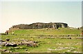
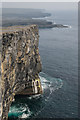
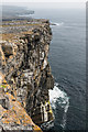
Dún Aonghasa, Inishmore
by Jeff Buck geograph for square L8109 Dún Aonghasa is one of several prehistoric hill forts on the Aran Islands,... (more)
Tags:
Aran IslandsX
place:Aran IslandsX
place:GalwayX
type:GeographX
Hill FortX
top:Historic Sites and ArtefactsX
place:Inishmore
top:IslandsX
Prehistoric Hill FortX
country:Republic of IrelandX
|
|
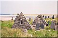
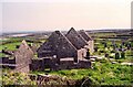
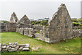
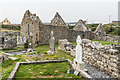
Na Seacht dTeampaill (The Seven Churches), Aran Islands
by Jeff Buck geograph for square L8112 The monastic ruins of Na Seacht dTeampaill (The Seven Churches) near the village... (more)
Tags:
Aran IslandsX
place:Aran IslandsX
CemeteryX
ChurchX
ruin:ChurchX
place:EoghanachtX
type:GeographX
top:Historic Sites and ArtefactsX
place:Inishmore
top:IslandsX
Monastic RuinsX
Religious SiteX
top:Religious SitesX
|
|
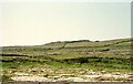
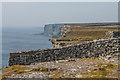
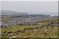
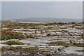
Dún Aonghasa
by Ian Capper geograph for square L8109 Looking along the limestone cliffs on the south south of Inishmore/Inis Mor from... (more)
|
|
Along the cliffs
by Ian Capper geograph for square L8109 Looking along the limestone cliffs on the south south of Inishmore/Inis Mor near... (more)
|
|
Along the cliffs
by Ian Capper geograph for square L8109 Looking along the limestone cliffs on the south south of Inishmore/Inis Mor near... (more)
|

|
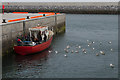
Departing on the Aran Flyer - May 1994
by Jeff Buck for square L8808 Tourists board the Aran Flyer at Kilronan (Cill Rónáin) before departing back to... (more)
Tags:
place:Aran IslandsX
Cill RonainX
place:Cill RonainX
type:Close LookX
top:Docks, HarboursX
FerryX
place:GalwayX
place:Inishmore
top:IslandsX
place:KilronanX
Kilronan HarbourX
|
|
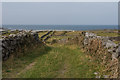
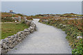
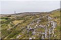
Path to Dún Aonghasa
by Ian Capper geograph for square L8210 Path connecting Kilmurvy/Cill Mhuirbhigh with the Iron Age fort of Dún Aonghasa.
|
|
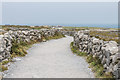
Path to Dún Aonghasa
by Ian Capper geograph for square L8209 Path connecting Kilmurvy/Cill Mhuirbhigh with the Iron Age fort of Dún Aonghasa.
|
|
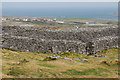
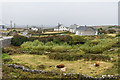
Dún Aonghasa
by Ian Capper geograph for square L8109 The outer ramparts of the Iron Age fort of Dún Aonghasa with the village of... (more)
Tags:
place:Cill MhuirbhighX
place:Dun AonghasaX
top:Historic Sites and ArtefactsX
place:Inis MorX
place:Inishmore
top:IslandsX
place:KilmurvyX
PortmurvyX
top:Village, Rural SettlementX
|
|
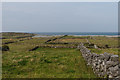
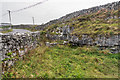
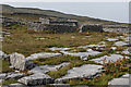
Limestone pavement
by Ian Capper geograph for square L8209 Limestone pavement alongside the track connecting Kilmurvy/Cill Mhuirbhigh and... (more)
Tags:
place:Cill MhuirbhighX
place:Dun AonghasaX
top:Geological InterestX
place:Inis MorX
place:Inishmore
top:IslandsX
place:KilmurvyX
Limestone PavementX
|
|
Limestone pavement
by Ian Capper geograph for square L8210 Limestone pavement alongside the track connecting Kilmurvy/Cill Mhuirbhigh and... (more)
Tags:
place:Cill MhuirbhighX
place:Dun AonghasaX
top:Geological InterestX
place:Inis MorX
place:Inishmore
top:IslandsX
place:KilmurvyX
Limestone PavementX
|
|
Limestone pavement
by Ian Capper geograph for square L7911 Limestone pavement near Bungowla/Bun Gabhla.
Tags:
place:Bun GabhlaX
place:BungowlaX
place:EoghanachtX
top:Geological InterestX
place:Inis MorX
place:Inishmore
top:IslandsX
Limestone PavementX
place:OnaghtX
|
|
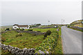
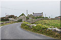
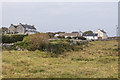
Bungowla/Bun Gabhla
by Ian Capper geograph for square L7911 Group of houses in Onaght/Eoghanacht townland.
Tags:
place:Bun GabhlaX
place:BungowlaX
place:EoghanachtX
top:Housing, DwellingsX
place:Inis MorX
place:Inishmore
top:IslandsX
place:OnaghtX
top:Village, Rural SettlementX
|
|
Creggacareen/Creig an Chéirín
by Ian Capper geograph for square L8012 Scattered housing in Onaght/Eoghanacht townland.
Tags:
place:CreggacareenX
place:Creig an CheirinX
place:EoghanachtX
place:Inis MorX
place:Inishmore
top:IslandsX
place:OnaghtX
top:Village, Rural SettlementX
|
|
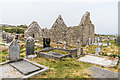
Na Seacht dTeampaill
by Ian Capper geograph for square L8112 Despite the name (which translated into English means "The Seven... (more)
Tags:
place:EoghanachtX
top:Housing, DwellingsX
place:Inis MorX
place:Inishmore
top:IslandsX
place:Na Seacht DTeampaillX
place:OnaghtX
top:Religious SitesX
place:The Seven ChurchesX
|
|
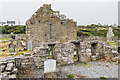
Teampall Bhreacáin, Na Seacht dTeampaill
by Ian Capper geograph for square L8112 Despite the name (which translated into English means "The Seven... (more)
Tags:
place:EoghanachtX
place:Inis MorX
place:Inishmore
top:IslandsX
place:Na Seacht DTeampaillX
place:OnaghtX
top:Religious SitesX
Teampall BhreacainX
place:The Seven ChurchesX
|
|
Teampall Bhreacáin, Na Seacht dTeampaill
by Ian Capper geograph for square L8112 Despite the name (which translated into English means "The Seven... (more)
Tags:
place:EoghanachtX
place:Inis MorX
place:Inishmore
top:IslandsX
place:Na Seacht DTeampaillX
place:OnaghtX
top:Religious SitesX
Teampall BhreacainX
|
|
Teampall Bhreacáin, Na Seacht dTeampaill
by Ian Capper geograph for square L8112 Despite the name (which translated into English means "The Seven... (more)
Tags:
place:EoghanachtX
place:Inis MorX
place:Inishmore
top:IslandsX
place:Na Seacht DTeampaillX
place:OnaghtX
top:Religious SitesX
Teampall BhreacainX
place:The Seven ChurchesX
|
|
Sruffaun/Sruthán
by Ian Capper geograph for square L8111 Hamlet in Kilmurvy townland.
|
|
Coastal fields
by Ian Capper geograph for square L8610 Coastal fields near Seipeal.
|
|
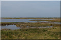
Loch Phort Chorruch
by Ian Capper geograph for square L8511 Shallow lagoon separated from the bay at Port Chorruch by a shingle beach.
|
|
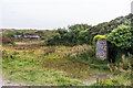
Former quarry(?)
by Ian Capper geograph for square L8410 An enclosed triangle of land (a former quarry?) alongside the road near... (more)
Tags:
place:Cill MhuirbhighX
place:Fearann an ChoirceX
place:Inis MorX
place:Inishmore
top:IslandsX
place:KilmurvyX
place:OatquarterX
top:Village, Rural SettlementX
|
|
Oatquarter/Fearann an Choirce
by Ian Capper geograph for square L8410 Group of houses in Kilmurvy/Cill Mhuirbhigh townland.
Tags:
place:Cill MhuirbhighX
place:Fearann an ChoirceX
place:Inis MorX
place:Inishmore
top:IslandsX
place:KilmurvyX
place:OatquarterX
top:Village, Rural SettlementX
|
|
Ballynacragga/Baile na Creige
by Ian Capper geograph for square L8510 Group of houses in Oghill/Eochaill townland.
Tags:
place:Baile Na CreigeX
place:BallynacraggaX
place:EochaillX
top:Housing, DwellingsX
place:Inis MorX
place:Inishmore
top:IslandsX
place:OghilX
|
|
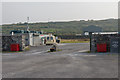
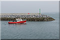
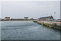
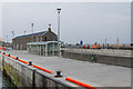
Kilronan/Cill Rónáin Harbour
by Ian Capper geograph for square L8808 The end of the breakwater constructed as part of a multi-million euro project... (more)
|
|
Quay, Kilronan/Cill Rónáin Harbour
by Ian Capper geograph for square L8808 On the right is part of the extension to the quay carried out as part of a... (more)
Tags:
place:Cill RonainX
top:CoastalX
top:Docks, HarboursX
Fish Processing FactoryX
place:Inis MorX
place:Inishmore
top:IslandsX
place:KilronanX
Kilronan HarbourX
National Inventory of Architectural HeritageX
NIAHX
|
|
Quay, Kilronan/Cill Rónáin Harbour
by Ian Capper geograph for square L8808 Extension to the quay carried out as part of a multi-million euro project... (more)
|
|
Quay, Kilronan/Cill Rónáin Harbour
by Ian Capper geograph for square L8808 Extension to the quay carried out as part of a multi-million euro project... (more)
Tags:
place:Cill RonainX
David KirkaldyX
top:Docks, HarboursX
Fish Processing FactoryX
place:Inis MorX
place:Inishmore
top:IslandsX
place:KilronanX
Kilronan HarbourX
LifeboatX
National Inventory of Architectural HeritageX
NIAHX
Severn ClassX
|
|
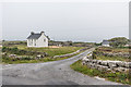
Kilmurvy/Cill Mhuirbhigh
by Ian Capper geograph for square L8210 The hamlet of Kilmurvy/Cill Mhuirbhigh.
|
|
Former quarry
by Ian Capper geograph for square L8210 Former quarry near Kilmurvy/Cill Mhuirbhigh.
|
|
Limestone pavement
by Ian Capper geograph for square L8109 Limestone pavement near Kilmurvy/Cill Mhuirbhigh.
Tags:
place:Cill MhuirbhighX
top:Geological InterestX
place:Inis MorX
place:Inishmore
top:IslandsX
place:KilmurvyX
Limestone PavementX
|
|
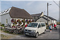
Kilmurvy/Cill Mhuirbhigh
by Ian Capper geograph for square L8210 Café in Kilmurvy/Cill Mhuirbhigh popular with visitors to Dún Aonghasa which... (more)
Tags:
top:Business, Retail, ServicesX
CafeX
place:Cill MhuirbhighX
place:Inis MorX
place:Inishmore
top:IslandsX
place:KilmurvyX
top:Village, Rural SettlementX
|