Public Tags
Other tags: Saintfield
Showing latest 50 of 64 images tagged with place:Saintfield tag.
|
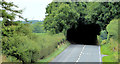
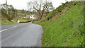
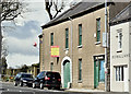
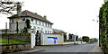
The Station Road, Saintfield (1)
by Albert Bridge geograph for square J4159 The Station Road J4159 : Former railway station, Saintfield is part of the road from Saintfield to Killyleagh.... (more)
|
|
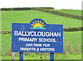
Former Ballycloughan Primary School near Saintfield (2013-3)
by Albert Bridge for square J4160 A redundant sign, with a background of Co Down drumlins, outside the school.
|
|
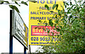
Former Ballycloughan Primary School near Saintfield (2013-2)
by Albert Bridge for square J4161 The agents For sale/to let board, partly hidden by vegetation, facing the... (more)
|
|
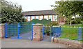
Former Ballycloughan Primary School near Saintfield (2013-1)
by Albert Bridge geograph for square J4161 The former Ballycloughan Primary School behind closed and padlocked gates. Had... (more)
|
|
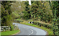
The Ballygowan Road, Ballycloughan near Saintfield
by Albert Bridge for square J4160 Part of the undulating Ballygowan Saintfield road as it skirts the drumlins of... (more)
|
|
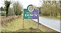
Down District boundary sign, Ballygowan/Saintfield (February 2015)
by Albert Bridge geograph for square J4161 A Down District Council boundary sign, at Ballycloughan, between Ballygowan... (more)
Tags:
place:Ballygowan (Down)X
subject:BoundaryX
BoundaryX
Boundary SignX
top:Boundary, BarrierX
place:Saintfield
|
|
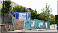
Disguised derelict buildings, Saintfield (April 2016)
by Albert Bridge geograph for square J4058 See J4058 : Development site, Saintfield (October 2012). Derelict buildings now hidden by mock facades.
|
|
New houses, Belfast Road, Saintfield (October 2015)
by Albert Bridge geograph for square J4059 See J4059 : Vacant house, Saintfield (2 in 2013) (November 2013). A back view of two new houses between the... (more)
|
|
The Station Road, Saintfield (3)
by Albert Bridge geograph for square J4159 See J4159 : The Station Road, Saintfield (2). The view towards Killyleagh from the same spot. This part of... (more)
|
|
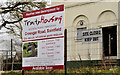
Development site, 42-44 Main Street, Saintfield (October 2017)
by Albert Bridge for square J4059 The former Sportsbar at 42-44 Main Street with a for sale sign. The agents... (more)
Tags:
Building (Vacant)X
type:Close LookX
subject:ConstructionX
top:Construction, DevelopmentX
top:Derelict, DisusedX
Development SiteX
Public House (Closed)X
place:Saintfield
|
|
Disguised derelict buildings, Saintfield - October 2017(2)
by Albert Bridge for square J4058 The Ballynahinch end of the disguised and derelict row.
Tags:
Buildings (Derelict)X
Buildings (Disguised)X
Buildings (Vacant)X
type:Close LookX
top:Derelict, DisusedX
place:Saintfield
|
|
Disguised derelict buildings, Saintfield - October 2017(1)
by Albert Bridge geograph for square J4058 Still disguised and derelict.
Tags:
Buildings (Derelict)X
Buildings (Disguised)X
Buildings (Vacant)X
top:Derelict, DisusedX
type:GeographX
place:Saintfield
|
|
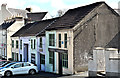
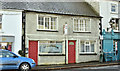
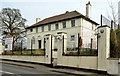
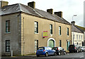
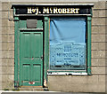
Nos 39-41 Main Street, Saintfield - April 2016(1)
by Albert Bridge geograph for square J4059 An 18th century building now offered for sale. The agents description includes... (more)
Tags:
subject:BuildingX
top:Business, Retail, ServicesX
former:Coach HouseX
top:Housing, DwellingsX
Public HouseX
place:Saintfield
|
|
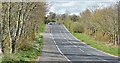
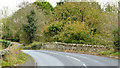
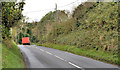
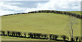
The Ballynahinch Road, Saintfield (April 2016)
by Albert Bridge geograph for square J3958 The Saintfield Ballynahinch road runs through classic Co Down drumlin country.... (more)
|
|
New social housing, Saintfield - October 2015(2)
by Albert Bridge for square J4058 The housing association apartments, built on the old police station site, on the... (more)
|
|
New social housing, Saintfield - October 2015(1)
by Albert Bridge geograph for square J4058 The new housing association properties nearing completion, built on the old... (more)
|
|
New social housing site, Saintfield (July 2014)
by Albert Bridge geograph for square J4058 New social housing now under construction, on the Crossgar Road, on the site of... (more)
|
|
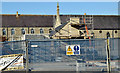
Former police station, Saintfield - March 2014(5)
by Albert Bridge for square J4058 The architects impression sign attached to the perimeter fence.
|
|
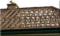
Former police station, Saintfield - March 2014(4)
by Albert Bridge for square J4058 The skeletal roof after removal of the slates.
|
|
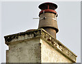
Former police station, Saintfield - March 2014(3)
by Albert Bridge for square J4058 A chimney, at the Crossgar end of the building, with a capped pot partly enclosed by mesh.
|
|
Former police station, Saintfield - March 2014(2)
by Albert Bridge geograph for square J4058 The building, seen from the town side, beside the Crossgar Road.
|
|
Former police station, Saintfield - March 2014(1)
by Albert Bridge geograph for square J4058 The closed police station, from the Crossgar side, still standing but with all... (more)
|
|
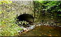
Stone bridge, Saintfield
by Albert Bridge geograph for square J4159 A stone bridge carrying the Station Road J4159 : The Station Road, Saintfield (1) over a stream J4159 : Stream, Saintfield (3)... (more)
|
|
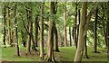
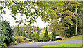
Trees, Rowallane, Saintfield
by Albert Bridge geograph for square J4157 Trees, close to the entrance to the National Trust Rowallane Garden J4057 : Rowallane,... (more)
|
|
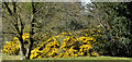
Whins, Saintfield (April 2016)
by Albert Bridge geograph for square J3958 A clump of whins, flowering among the bushes, to the west of the Ballynahinch... (more)
|
|
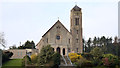
Roman Catholic church, Saintfield
by Albert Bridge geograph for square J4058 Mary Mother of the Church Roman Catholic church, on the Crossgar Road, dates... (more)
|
|
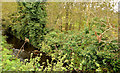
Stream and bridge, Saintfield (2)
by Albert Bridge geograph for square J4059 See J4059 : Stream and bridge, Saintfield (April 2013). The view from the upstream side.
|
|
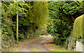
The Old Cart Road, Saintfield (1)
by Albert Bridge geograph for square J4059 The Comber Road end of a very narrow road running towards the Demesne.... (more)
|
|
The Comber Road, Saintfield
by Albert Bridge geograph for square J4059 A well-planted and landscaped cul-de-sac on the eastern side of the Comber Road.... (more)
|
|
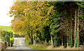
Autumn trees, Saintfield
by Albert Bridge geograph for square J4059 Autumn trees near the Belfast Road end of the Windmill Road.
|
|
The Station Road, Saintfield (2)
by Albert Bridge geograph for square J4159 See J4159 : The Station Road, Saintfield (1). The Station Road, further out towards Killyleagh, looking back... (more)
|
|
Stream, Saintfield (3)
by Albert Bridge geograph for square J4159 See J4159 : Stream, Saintfield (2). The same stream, looking upstream, from this bridge... (more)
|
|
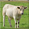
Cattle, Saintfield (2)
by Albert Bridge for square J4157 Part of a mixed herd on the western side of the Crossgar Road.
|
|
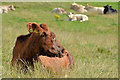
Cattle, Saintfield (1)
by Albert Bridge for square J4157 Part of a mixed herd on the eastern side of the Crossgar Road.
|
|
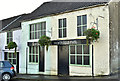
Nos 39-41 Main Street, Saintfield (October 2017)
by Albert Bridge geograph for square J4059 See J4059 : Nos 39-41 Main Street, Saintfield - April 2016(1). Still with a for sale sign.
Tags:
subject:BuildingX
Building (Vacant)X
top:Derelict, DisusedX
type:GeographX
Public House (Closed)X
place:Saintfield
|
|
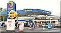
Maxol and Spar, Saintfield (October 2017)
by Albert Bridge geograph for square J4058 A Maxol petrol station and Spar shop at 11A Crossgar Road. The shop now... (more)
Tags:
top:Business, Retail, ServicesX
type:GeographX
petrol station:MaxolX
MaxolX
Petrol StationX
Post OfficeX
place:Saintfield
SparX
shop:SparX
|
|
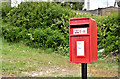
Postbox BT23 406, Carrickmannan, Saintfield/Darragh Cross (April 2017)
by Albert Bridge for square J4460 New pressed-steel postbox (BT23 406) at the crossroads end of the Kilcarn Road.
Tags:
top:Business, Retail, ServicesX
type:Close LookX
top:CommunicationsX
Darragh CrossX
subject:PostboxX
PostboxX
place:Saintfield
|
|
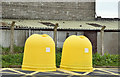
Recycling bins, Saintfield (April 2017)
by Albert Bridge for square J4058 Bright yellow recycling bins, for mixed glass, at the Downpatrick Street car park.
Tags:
subject:BinX
BinsX
type:Close LookX
Recycling BinsX
place:Saintfield
top:Waste, Waste ManagementX
|
|
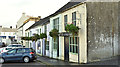
Nos 39-41 Main Street, Saintfield - April 2016(2)
by Albert Bridge for square J4059 See J4059 : Nos 39-41 Main Street, Saintfield - April 2016(1). Part of the premises fronting Main Street.
Tags:
subject:BuildingX
top:Business, Retail, ServicesX
former:Coach HouseX
DoorX
top:Housing, DwellingsX
Public HouseX
place:Saintfield
SignwritingX
WindowX
|
|
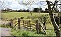
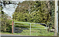
Field gates, Saintfield (April 2016)
by Albert Bridge geograph for square J3958 Two gates, leading to drumlin fields, on the eastern side of the Ballynahinch... (more)
Tags:
top:Boundary, BarrierX
top:Farm, Fishery, Market GardeningX
Field GatesX
FieldsX
subject:GateX
GatesX
place:Saintfield
|
|
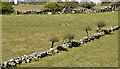
Drystone walls, Saintfield - April 2016(2)
by Albert Bridge geograph for square J3958 Drystone walls, between fields, to the south west of the Ballynahinch Road J3958 : The Ballynahinch Road, Saintfield (April 2016).
Tags:
top:Boundary, BarrierX
Drystone WallsX
top:Farm, Fishery, Market GardeningX
FieldsX
place:Saintfield
WallsX
|
|
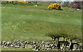
Drystone wall, Saintfield - April 2016(1)
by Albert Bridge geograph for square J3958 A drystone wall, between fields, to the west of the Ballynahinch Road J3958 : The Ballynahinch Road, Saintfield (April 2016).
Tags:
top:Boundary, BarrierX
Drystone WallX
top:Farm, Fishery, Market GardeningX
FieldsX
place:Saintfield
subject:WallX
WallX
|
|
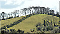
Drumlin, Saintfield - April 2016(2)
by Albert Bridge geograph for square J3958 See J3958 : Drumlin and trees, Saintfield (December 2012). The same drumlin, visible from the... (more)
|
|
Drumlin, Saintfield - April 2016(1)
by Albert Bridge geograph for square J3958 Well-rounded drumlin to the south east of the Ballynahinch Road J3958 : The Ballynahinch Road, Saintfield (April 2016).
|
|
Field gate, Saintfield (April 2016)
by Albert Bridge geograph for square J4058 A gate leading to a field on the north western side of the Ballynahinch Road.... (more)
Tags:
top:Boundary, BarrierX
top:Farm, Fishery, Market GardeningX
FieldX
Field GateX
subject:GateX
place:Saintfield
|
|
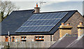
Solar panels, Saintfield (April 2016)
by Albert Bridge for square J4059 Solar panels on a house near the Lisburn Road.
|

|
Assembly election poster, Saintfield (April 2016)
by Albert Bridge for square J4058 Lisburn Road/Ballynahinch Road. Philip Smith and Mike Nesbitt (Ulster Unionist Party).
|

|
Chip shop, Saintfield (April 2016)
by Albert Bridge for square J4059 Eating Options at 55 Main Street.
|
|
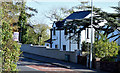
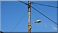
Metal telegraph pole, Saintfield (October 2015)
by Albert Bridge for square J4059 A metal telegraph pole, with attached streetlight, on the Belfast Road close to... (more)
Tags:
British TelecomX
top:CommunicationsX
subject:PoleX
PoleX
place:Saintfield
StreetlightX
Telegraph PoleX
Telephone WiresX
|
|
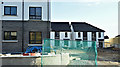
New houses under construction, Saintfield (October 2015)
by Albert Bridge geograph for square J4059 New houses now under construction on what had been a long-term vacant site... (more)
Tags:
subject:ConstructionX
Construction SiteX
top:Construction, DevelopmentX
Houses Under ConstructionX
top:Housing, DwellingsX
place:Saintfield
|