Public Tags
Tag: Ruined·Bridge
Showing images tagged with Ruined Bridge tag.
|
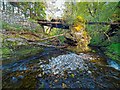
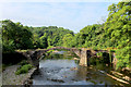
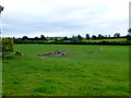
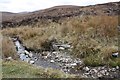
Ruined Bridge over the River Glass
by valenta geograph for square NH5568 Marked on the OS maps as a bridge, what looks like an old estate bridge over the... (more)
Tags:
subject:BridgeX
top:Derelict, DisusedX
type:GeographX
river:River GlassX
top:Rivers, Streams, DrainageX
top:Rocks, Scree, CliffsX
subject:RuinX
Ruined Bridge
top:UplandsX
top:Woodland, ForestX
|
|
Fleety Cottage ruin
by Jim Barton geograph for square NT5106 A ruined cottage by the Slitrig Water which has carried away the bridge in some... (more)
Tags:
top:Derelict, DisusedX
type:GeographX
top:Housing, DwellingsX
top:Rivers, Streams, DrainageX
Ruined Bridge
Ruined CottageX
river:Slitrig WaterX
|
|
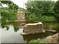
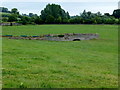
Remains of footbridge, Stockbriggs Estate
by Alan O'Dowd geograph for square NS7936 The map still shows a path and footbridge crossing here, but the span of the... (more)
Tags:
top:Country EstatesX
type:GeographX
top:PathsX
subject:RuinX
Ruined Bridge
Ruined FootbridgeX
top:Woodland, ForestX
|
|
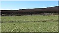
Remains of a bridge
by Richard Webb geograph for square NN4495 Category: Ruins The maps of the Highlands are getting old now. I am of a generation who took to... (more)
Tags:
top:Derelict, DisusedX
top:MoorlandX
Removed BridgeX
top:Rivers, Streams, DrainageX
Ruined Bridge
river:SpeyX
|

|
Remains of destroyed bridge below Brown's Houses
by Karl and Ali geograph for square SD4673 The concrete bridge probably connected with a track which is still apparent on... (more)
Tags:
ruin:BridgeX
top:CoastalX
top:Derelict, DisusedX
top:Roads, Road TransportX
Ruined Bridge
Tidal ChannelX
|
|
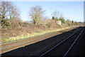
View of ruined bridge over railway at Lower Green Farm
by Roger Templeman geograph for square SO8109 Tags:
bridge:Farm Track Over RailwayX
type:GeographX
Railway SignalX
Railway TracksX
top:RailwaysX
Ruined Bridge
|
|
Ruined bridge
by Richard Webb geograph for square NO5883 The bridge over the Burn of Badymicks shown here NO5883 : Foot bridge and Stable, Glen Dye. has been swept away.
Tags:
BurnX
top:Derelict, DisusedX
top:MoorlandX
top:Rivers, Streams, DrainageX
top:Roads, Road TransportX
Ruined Bridge
Upland RoadX
|
|
The Bridge Over The Shalloch Burn
by Rude Health geograph for square NX3789 I preferred not to cross this ruined bridge as the guide book suggested. So I... (more)
|
|
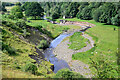
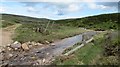
Ruined bridge and ford
by Richard Sutcliffe geograph for square NS7179 Alternative ways of crossing the Bachille Burn.
Tags:
BurnX
subject:FordX
type:GeographX
top:GrasslandX
top:Rivers, Streams, DrainageX
top:Rocks, Scree, CliffsX
Ruined Bridge
|
|
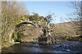
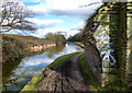
Cromwell's Bridge
by Chris Heaton geograph for square SD7039 Ancient packhorse bridge crossing the River Hodder about a mile north of its... (more)
|
|
The remains of Eastham Bridge
by Alan Murray-Rust geograph for square SO6569 Eastham Bridge collapsed in May 2016, the most likely cause being scour of the... (more)
Tags:
bridge:Brick ArchX
type:GeographX
Grade II ListedX
top:Rivers, Streams, DrainageX
Ruined Bridge
river:TemeX
|
|
Causeway and bridge remains
by Richard Webb geograph for square NN7177 A former course of the Edendon Water is shown by the remains of a bridge. The... (more)
Tags:
p150 hill:An DunX
top:Derelict, DisusedX
river:Edendon WaterX
type:GeographX
top:MoorlandX
top:Roads, Road TransportX
Ruined Bridge
|
|
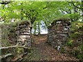
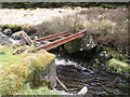
Underneath the old railway footbridge near Windrow Wood
by Alan O'Dowd geograph for square NS8129 A view from the course of the former Muirkirk Branch of the Caledonian Railway... (more)
|
|
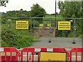
Warning Dangerous Structure
by Alan Murray-Rust geograph for square SO6569 In practice there is little structure left to be dangerous.
Eastham Bridge... (more)
Tags:
top:Derelict, DisusedX
type:GeographX
Grade II ListedX
Road ClosureX
top:Roads, Road TransportX
Ruined Bridge
|
|
Deuchar Bridge
by Walter Baxter geograph for square NT3627 Its getting more difficult to access the north bank of the Yarrow Water to take... (more)
|
|
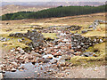
Remains of Wade bridge over the Allt a' Mhill Ghairbh
by Jim Barton geograph for square NN4596 The bridge for the Wade Military Road has gone but the masonry buttresses... (more)
Tags:
Coniferous PlantationX
top:Derelict, DisusedX
General Wade RoadX
type:GeographX
top:Historic Sites and ArtefactsX
top:MoorlandX
top:PathsX
top:Rivers, Streams, DrainageX
Ruined Bridge
TrackX
top:UplandsX
|
|
Bridge down, River Lynher
by Derek Harper geograph for square SX3466 Byway 631/1/1 comes to an abrupt halt here because the bridge is no longer... (more)
Tags:
top:LowlandsX
river:LynherX
top:Rivers, Streams, DrainageX
Riverside TreesX
Ruined Bridge
WoodlandX
top:Woodland, ForestX
|
|
Remains of a bridge, Caledon
by Kenneth Allen geograph for square H7545 Looking north-east from the A28
Tags:
top:Roads, Road TransportX
Ruined Bridge
|
|
Remains of a bridge, Caledon
by Kenneth Allen geograph for square H7545 The mill lace ran past here
Tags:
top:Roads, Road TransportX
Ruined Bridge
|
|
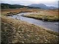
Remains of the bridge over the Geldie Burn
by Richard Webb geograph for square NO0086 Now a traverse of the Glen Tilt Mounth road requires a potentially difficult... (more)
|
|
Broken Down Bridge
by Des Blenkinsopp geograph for square TQ0280 Tags:
top:CanalsX
Ruined Bridge
|
|
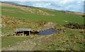
Remains of a bridge, Allt nam Breac Buidhe
by Dorothy Carse geograph for square NC5463 On a track to peat bogs no longer in use.
Tags:
top:Derelict, DisusedX
top:MoorlandX
top:Rivers, Streams, DrainageX
Ruined Bridge
top:UplandsX
|