|
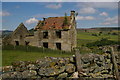
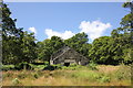
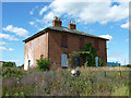
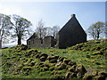
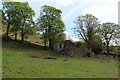
Stork House, ruined farm
by Christopher Hilton
geograph for square SE6294
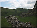
Stork House has been abandoned since at least the 1970s. Beyond it on the far... (more)
|
|
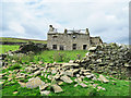
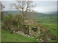
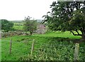
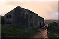
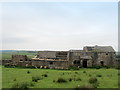
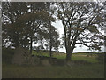
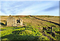
Ruined farmhouse and barn, Weasdale
by Karl and Ali
geograph for square NY6903
|
|
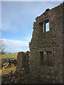
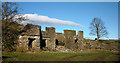
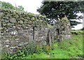
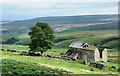
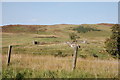
The ruins of Tenter Howe, Longsleddale
by Karl and Ali
geograph for square NY5100
A ruined farmhouse and outbuildings in the middle dale. Whiteside Pike catches... (more)
|
|
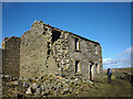
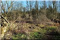
Ruined farmhouse, Arkengarthdale
by Karl and Ali
geograph for square NZ0300
This once handsome farmhouse has no name on the map. More importantly, it has no... (more)
|
|
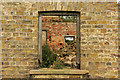
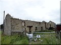
Ruined farmhouse
by Richard Croft
for square TF1468
View through a window of the ruined farmhouse at the west end of Tupholme Abbey... (more)
|
|
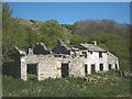
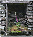
A thing of beauty in a place of ruin
by Karl and Ali
for square SD1994
A foxglove grows in an alcove in the ruined farmhouse at Grimecrag.
|
|
Ruined farmhouse at Tomen-y-mur
by Jeff Buck
geograph for square SH7038
Category: Farmhouse (ruined)
A ruined farmhouse next to the Norman Motte and Roman fort at Tomen-y-mur.
|
|
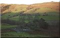
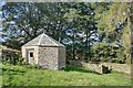
Peatrigg and the lands to the west
by Christopher Hilton
geograph for square NY7568
|
|
The ruins of Sunny Bank farmhouse
by Christine Johnstone
geograph for square SD9931
Shown unruined on all the large scale OS maps from the 1890s to the 1930s.
|
|
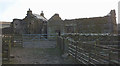
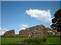
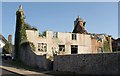
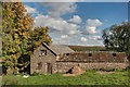
College
by Trevor Littlewood
geograph for square NZ0049
The ruined farmhouse (with included barn) and the ruined wall surrounding what... (more)
|
|
Ruined farmhouse, Cowgill Farm
by Karl and Ali
for square SD6874
|
|
Derelict farmhouse, Black Hill
by Karl and Ali
geograph for square SD7660
A sad ruin falling into advanced disrepair most likely due to its remote... (more)
|
|
Ruined Farmhouse
by Rude Health
geograph for square SH6507
I passed this ruined farmhouse which may have been called Pen-y-bryniau on the... (more)
|
|
Ruined farmhouse at Raisbank
by Karl and Ali
geograph for square NY6005
Another large, abandoned farmhouse passed on today's walk.
|
|
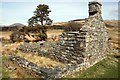
The ruins of Grimecrag (Grimcrag)
by Karl and Ali
geograph for square SD1994
On my old map this place is called Grimcrag. It's a sad, derelict ruin but... (more)
|
|
Ruins at Hill Top
by Robert Graham
geograph for square NZ0854
This ruined farm stands beside a back road between Shotley Bridge and Ebchester.... (more)
|
|
Ruined Farmhouse in the Cwm Cloch Curves
by Jeff Buck
geograph for square SH5847
A ruined farmhouse next to the Welsh Highland Railway at Beddgelert.
|
|
Ruined house near Peggleswright
by Karl and Ali
geograph for square SD7286
This fine old farmhouse has several trees growing out of it. The tallest one... (more)
|
|
The ruins of East View
by Karl and Ali
geograph for square SD5298
Getting ever more decrepit and ruinous.
|
|
Ruined farmhouse at Drover House
by Robert Graham
geograph for square NZ0942
This farmstead stands beside the A68 in quite an exposed situation. This was no... (more)
|
|
Park Springs farmhouse
by Richard Croft
geograph for square SK8388
The farm buildings have been demolished and the site cleared, but Park Springs... (more)
|
|
Ruined house, Combe Pafford
by Derek Harper
geograph for square SX9166
The sad remains of a listed farmhouse (described at... (more)
|
|
Old ruin at Fell Close
by Robert Graham
geograph for square NZ0647
This little ruined farmhouse is in the fields east of Healeyfield Lane. It has... (more)
|
|
Ruined farm buildings at Wester Barnego
by Alan O'Dowd
for square NS7884
Wester Barnego and Easter Barnego have fallen by the wayside, but farming... (more)
|
|
Ruined farmhouse at Cairnsaigh
by Alan O'Dowd
geograph for square NS6136
This roofless cottage and some crumbling outbuildings to the rear are all that... (more)
|
|
Nook, Crimsworth
by Phil Champion
geograph for square SD9831
A ruined farmhouse by the bridleway along Crimsworth Dean. Part of the building... (more)
|
|
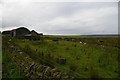
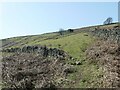
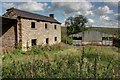
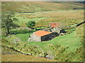
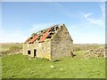
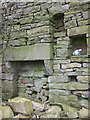
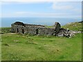
Brewster Hill
by Mick Garratt
geograph for square SE5292
|
|
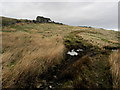
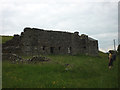
Brewster Hill
by Mick Garratt
geograph for square SE5292
|
|
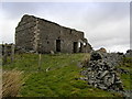
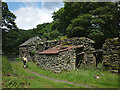
Brewster Hill
by Mick Garratt
geograph for square SE5292
|
|
Stone fireplace, abandoned farmhouse at Bretherdale Head
by Karl and Ali
for square NY5705
As with so many of the abandoned farmhouses in the dale all is ruin and decay.... (more)
|
|
Earlshaugh
by Iain Russell
geograph for square NT0714
Category: Farmhouse (ruined)
Remains of a remote farmhouse.
|
|
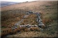
Ruined farmhouse near Stannon Tor
by Sandy Gerrard
geograph for square SX6481
Scale 2m... (more)
|
|
Farmhouse ruin at Fell Close
by Robert Graham
geograph for square NZ0647
Compared to earlier pictures here, the building has deteriorated quite a bit.... (more)
|
|
Ruined Farmhouse on Hunters Sleet (3)
by Chris Heaton
geograph for square SD9876
Un-named derelict farmhouse.
Penny Mayes sent an email to me, informing this... (more)
|
|
Ruined Farmhouse on Hunters Sleet (2)
by Chris Heaton
geograph for square SD9876
Un-named ruin high above the source waters of the River Cover
Penny Mayes... (more)
|
|
Minish: Would suit DIY enthusiast
by Chris Downer
geograph for square NF9070
A ruined farmhouse for which the above estate agent's description would be... (more)
|
|
Scalehow, a ruined farmhouse at the head of Bretherdale
by Karl and Ali
geograph for square NY5605
This farmhouse, long abandoned and decayed sits at the remote head of a secluded... (more)
|
|
Higher Coppy
by Chris Heaton
geograph for square SD9540
Ruined farmhouse on the edge of Emmott Moor. The following missive was sent to... (more)
|
|
Ruin near Lapthorne Farm
by Derek Harper
geograph for square SX8553
"A ruined farmhouse at Halwell, Dittisham, has only its eastern wall... (more)
|
|
Sandyford
by Trevor Littlewood
geograph for square NY9647
The ruins of Sandyford, a farmhouse with attached barn on the north-western... (more)
|
|
Derelict Farmhouse above Bridgehouse Beck
by Chris Heaton
geograph for square SE0336
Falling into a ruin, and now possibly beyond the point of no return.
|
|
The ruins of Gill House
by Karl and Ali
geograph for square SE0168
There isn't much left to see of what must have once been a substantial hill... (more)
|
|
Ruin of Whitehillock farm
by Bill Harrison
geograph for square NJ4425
A ruined farmhouse and water mill beside the Burn of Craig. Canmore reference... (more)
|
|
Ruins of Cote Garth
by Derek Harper
geograph for square SE4698
The ruins of a farmhouse beside footpath 10 111/021.
|

|
Interior of Fell Close
by Robert Graham
for square NZ0647
The old floor beams in the ruined farmhouse at Fell Close. Particularly... (more)
|
|
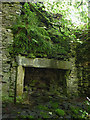
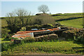
Fireplace in ruin on Green Rigg, Dentdale
by Karl and Ali
for square SD7286
|
|
The ruins of Waters
by Karl and Ali
geograph for square NY5904
Yet another abandoned and decaying farmhouse in Bretherdale.
|
|
Ruin and decay at Bretherdale Head
by Karl and Ali
geograph for square NY5705
The dale is a beautifully secluded backwater virtually devoid of human... (more)
|
|
Ruined building above Barmouth
by Malc McDonald
geograph for square SH6116
A ruined building on the hillside overlooking Barmouth, on the coast of north Wales.
|
|
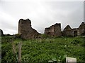
Ruin of Flushiemere House
by Trevor Littlewood
geograph for square NY9031
Flushiemere House has been deteriorating for decades and is now, (November... (more)
|