Public Tags
Tag: Shelter·Belt
Showing latest 50 of 486 images tagged with Shelter Belt tag.
|
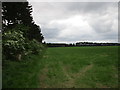
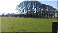
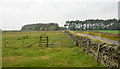
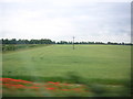
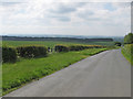
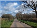
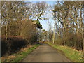
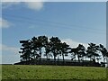
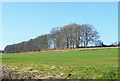
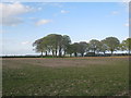
View alongside a shelter belt towards another shelter belt
by Jonathan Thacker geograph for square SK6382 Shelter belts, usually of pine, are a characteristic of this area,
Tags:
top:LowlandsX
Shelter BeltsX
|
|
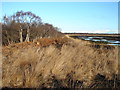
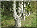
Shelter belt
by Ian Paterson geograph for square SE7105 Line of silver birch bordering one of the many peat bogs on Hatfield Moors.
|
|
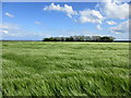
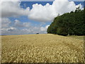
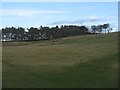
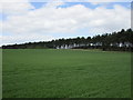
Barley field and shelter belt
by Jonathan Thacker geograph for square TA0770 The shelter belt protects Refuge Farm.
Tags:
top:LowlandsX
Shelter Belt
|
|
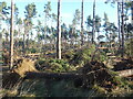
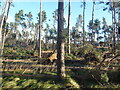
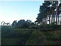
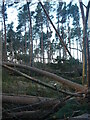
East Lothian Landscape : Storm-damaged Shelter-belt at Hedderwick Hill
by Richard West geograph for square NT6378 On Friday 26th November 2021, a deep depression, named Storm Arwen, moved... (more)
Tags:
top:Flat LandscapesX
type:GeographX
Hedderwick HillX
Scots PineX
Shelter Belt
Storm ArwenX
Storm Damaged TreesX
subject:TreeX
top:Woodland, ForestX
|
|
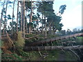
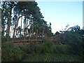
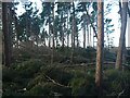
East Lothian Landscape : Wind-felled Trees at Hedderwick Hill Shelter-belt
by Richard West geograph for square NT6378 On Friday 26th November 2021, a deep depression, named Storm Arwen, moved... (more)
Tags:
Field MarginX
top:Flat LandscapesX
type:GeographX
Hedderwick HillX
Scots PineX
Shelter Belt
Storm ArwenX
Storm Damaged TreesX
subject:TreeX
top:Woodland, ForestX
|
|
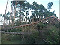
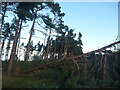
East Lothian Landscape : Storm-felled Trees at Hedderwick Hill Shelter-belt
by Richard West geograph for square NT6378 On Friday 26th November 2021, a deep depression, named Storm Arwen, moved... (more)
Tags:
Field MarginX
top:Flat LandscapesX
type:GeographX
Hedderwick HillX
Scots PineX
Shelter Belt
Storm ArwenX
Storm Damaged TreesX
subject:TreeX
top:Woodland, ForestX
|
|
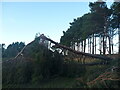
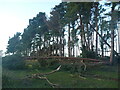
East Lothian Landscape : Storm-felled Trees at Hedderwick Hill Shelter-belt
by Richard West geograph for square NT6378 On Friday 26th November 2021, a deep depression, named Storm Arwen, moved... (more)
Tags:
Field MarginX
top:Flat LandscapesX
type:GeographX
Hedderwick HillX
Scots PineX
Shelter Belt
Storm ArwenX
Storm Damaged TreesX
subject:TreeX
top:Woodland, ForestX
|
|
East Lothian Landscape : Storm Damage at Hedderwick Hill Shelter-belt
by Richard West geograph for square NT6378 On Friday 26th November 2021, a deep depression, named Storm Arwen, moved... (more)
Tags:
Field MarginX
top:Flat LandscapesX
type:GeographX
Hedderwick HillX
Scots PineX
Shelter Belt
Storm ArwenX
Storm Damaged TreesX
subject:TreeX
top:Woodland, ForestX
|
|
East Lothian Landscape : Storm-felled Trees at Hedderwick Hill Shelter-belt
by Richard West geograph for square NT6378 On Friday 26th November 2021, a deep depression, named Storm Arwen, moved... (more)
Tags:
Field MarginX
top:Flat LandscapesX
type:GeographX
Hedderwick HillX
Scots PineX
Shelter Belt
Storm ArwenX
Storm Damaged TreesX
subject:TreeX
top:Woodland, ForestX
|
|
East Lothian Landscape : Storm-damaged Shelter-belt at Hedderwick Hill
by Richard West geograph for square NT6378 On Friday 26th November 2021, a deep depression, named Storm Arwen, moved... (more)
Tags:
Field MarginX
top:Flat LandscapesX
type:GeographX
Hedderwick HillX
Scots PineX
Shelter Belt
Storm ArwenX
Storm Damaged TreesX
subject:TreeX
top:Woodland, ForestX
|
|
East Lothian Landscape : Storm-felled Trees In Hedderwick Hill Shelter-belt
by Richard West geograph for square NT6378 On Friday 26th November 2021, a deep depression, named Storm Arwen, moved... (more)
Tags:
top:Flat LandscapesX
type:GeographX
Hedderwick HillX
Scots PineX
Shelter Belt
Storm ArwenX
Storm Damaged TreesX
subject:TreeX
top:Woodland, ForestX
|
|
East Lothian Landscape : Storm Damage at Hedderwick Hill Shelter-belt
by Richard West geograph for square NT6378 On Friday 26th November 2021, a deep depression, named Storm Arwen, moved... (more)
Tags:
top:Flat LandscapesX
type:GeographX
Hedderwick HillX
Scots PineX
Shelter Belt
Storm ArwenX
Storm Damaged TreesX
subject:TreeX
top:Woodland, ForestX
|
|
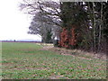
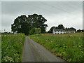
Shelter belt Spikers Hill Farm
by Christopher Hall geograph for square SE9887 A classic shelter belt to the north of the farm viewed from the public footpath
Tags:
top:Farm, Fishery, Market GardeningX
type:GeographX
PastureX
top:PathsX
Public FootpathX
Shelter Belt
|
|
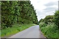
Shelter belt near Longformacus
by M J Richardson for square NT6858 A Beech shelter belt separating Haddington Covert from the road, with some good... (more)
Tags:
trees:BeechX
type:Close LookX
Conifer PlantationX
place:Lammermuir HillsX
near:LongformacusX
Roadside TreesX
place:Scottish BordersX
Shelter Belt
top:UplandsX
top:Wild Animals, Plants and MushroomsX
subject:WoodlandX
top:Woodland, ForestX
|
|
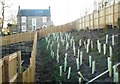
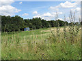
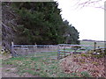
Newly planted shelter belt
by Richard Sutcliffe for square NS5572 Trees or shrubs (species unknown) have been planted to form a shelter belt... (more)
Tags:
type:Close LookX
top:Housing, DwellingsX
Newly PlantedX
Shelter Belt
subject:TreeX
Wooden FencesX
top:Woodland, ForestX
|
|
Shelter belt
by Ian Capper geograph for square NU1337 A shelter belt on Ross Farm.
Tags:
top:Farm, Fishery, Market GardeningX
type:GeographX
place:RossX
farm:Ross FarmX
Shelter Belt
top:Woodland, ForestX
|
|
Wheatfield and shelter belt
by Jonathan Thacker geograph for square SE9272 The shelter belt protects Whin Moor Farm from wind from the north and west.... (more)
|
|
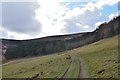
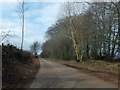
Track to shelter belt
by Jim Barton geograph for square NT2636 A track with a shelter belt between the hill pasture and open moorland.
Tags:
top:GrasslandX
Hill TrackX
top:MoorlandX
top:PathsX
top:Roads, Road TransportX
Shelter Belt
Upland FarmlandX
top:UplandsX
top:Woodland, ForestX
|
|
Shelter belts beside B6320
by Trevor Littlewood geograph for square NY8892 The B6320 runs south from the village of Otterburn and connects the A696 with... (more)
|
|
Pasture and shelter belt at Blairburn
by M J Richardson geograph for square NT2254 I presume the burn shown as running down the shelter belt is Blair Burn, running... (more)
Tags:
top:Farm, Fishery, Market GardeningX
top:GrasslandX
place:LeadburnX
top:LowlandsX
PastureX
Shelter Belt
top:Woodland, ForestX
|
|
Track and shelter belt, Flixton Carr
by Christopher Hall geograph for square TA0380 The track runs north north-west from Woodhouse Farm, just seen in the... (more)
|
|
Joining the A63 at North Ferriby
by Derek Harper geograph for square SE9826 From a bus on the B1231 Melton Road, just joining a slip road on which there are... (more)
|
|
Fields and shelter-belts around Highfield Farm, from the train
by Christopher Hilton geograph for square TL3240 |
|
Shelter belt, Toyd Farm
by Maigheach-gheal geograph for square SU0820 There is a small area of mixed woodland beside the farm which acts a shelter belt.
|
|
Shelter belt near Godhams Farm
by David Smith geograph for square ST0028 The belt on the right, a few trees deep, stretches from the road to Godhams Farm... (more)
|
|
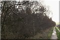
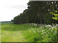
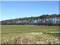
Along the shelter belt
by Pauline E geograph for square SE6185 The belt of conifers extends for about a kilometre to Scadale Howl Plantation.
Tags:
Shelter Belt
top:Woodland, ForestX
|
|
Shelter belt off Carlton Road
by Pauline E geograph for square SE6185 The long thin belt of conifers runs north of Cliff Stud. The road drops down to... (more)
|
|
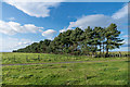
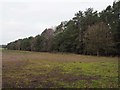
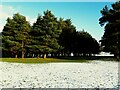
Shelter Belt
by David Pashley geograph for square TL7997 Common feature of Breckland are these conifer belts.
Tags:
Breckland LandscapeX
top:Farm, Fishery, Market GardeningX
top:Flat LandscapesX
type:GeographX
subject:HedgeX
Shelter Belt
Thetford ForestX
top:Woodland, ForestX
|
|
Shelter belt near Woodlea
by Oliver Dixon geograph for square NT5884 A belt of Scots Pines.
Tags:
top:Farm, Fishery, Market GardeningX
FieldX
Scots PinesX
Shelter Belt
WoodX
subject:WoodlandX
top:Woodland, ForestX
|
|
Tree belt near Froxfield
by Derek Harper geograph for square SU2868 A shelter belt of trees, seen from the road between Froxfield and Rudge, which... (more)
|
|
Trees in a shelter belt at Cranford Park
by David Smith geograph for square SS5521 The trees on the right shelter the house, whose entrance is where the road widens
|
|
New tree planting at Mayshiels
by M J Richardson for square NT6264 A shelter belt along the B6355, with strip of young trees protected by tree... (more)
Tags:
type:Cross GridX
Crystal RigX
place:East LothianX
Electricity PylonsX
top:Energy InfrastructureX
top:Farm, Fishery, Market GardeningX
top:GrasslandX
place:Lammermuir HillsX
LandscapeX
top:MoorlandX
Shelter Belt
top:UplandsX
Wind TurbinesX
subject:WoodlandX
top:Woodland, ForestX
|
|
Shelter belt at Johnscleugh
by M J Richardson for square NT6366 The farm is sheltered behind the trees. Note the signs of the Whiteadder Water... (more)
Tags:
plant:BrackenX
type:Cross GridX
place:East LothianX
Farm RoadX
top:Farm, Fishery, Market GardeningX
top:GrasslandX
MeandersX
top:MoorlandX
subject:RiverX
River Bank ErosionX
top:Rivers, Streams, DrainageX
Shelter Belt
Upland FarmlandX
top:UplandsX
river:Whiteadder WaterX
top:Woodland, ForestX
|
|
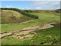
Shelter belt at Halkburn
by M J Richardson for square NT4740 Looking east up the valley of the Halk Burn, towards Murder Cleuch.
Tags:
top:Farm, Fishery, Market GardeningX
FarmlandX
FieldsX
top:MoorlandX
place:Scottish BordersX
subject:ShelterX
Shelter Belt
top:UplandsX
top:Woodland, ForestX
|
|
Road through the shelter belts
by M J Richardson geograph for square NT5884 That on the left is Blackdykes Strip and the one on the right is Halfland Strip... (more)
Tags:
BlackdykesX
top:Farm, Fishery, Market GardeningX
top:LowlandsX
RoadX
Shelter BeltsX
top:Woodland, ForestX
|
|
Line of trees along a field boundary
by Stephen Craven geograph for square SD8642 Quite a long line: this shelter belt of trees runs for about 360m northwards, of... (more)
|
|
Pendle Side Farm
by Stephen Craven for square SD8141 The farm has an extensive shelter belt to the north.
|
|
Tall pines at Scargill
by Stephen Craven geograph for square SD9771 A shelter belt to the south of the main buildings.
|
|
Lodge Farm
by Stephen Craven geograph for square SE3450 The trees are presumably intended as a shelter belt, as the farm is on top of a... (more)
|
|
Home Farm
by Stephen Craven geograph for square NH5151 The farmhouse is well protected from westerly winds by the shelter belt of... (more)
|
|
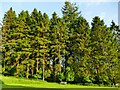
The effect of a shelter belt
by Stephen Craven geograph for square SE2335 The ground beneath the trees, and in the firebreak between them, was free of... (more)
|
|
Glen Orkie
by Stephen Craven geograph for square NO3007 The farmstead NO3007 : Spreading chestnut tree is shielded from view from this direction by a shelter... (more)
|
|
Shelter Belt near Wombwell's Farm
by Des Blenkinsopp geograph for square SP6910 This field is protected by lines of trees on two sides.
|
|
Shelter belt of pine trees
by Jonathan Thacker geograph for square SK6179 Typical of this area of light soils.
|
|
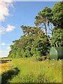
Blue container
by Pauline E geograph for square SE6451 Behind is a shelter belt south of the Farming Museum.
|
|
Cairneymount Covert
by Jim Barton geograph for square NT5439 A shelter belt alongside the minor road heading E towards Earlston. Compare with... (more)
|
|
Tumulus and shelter belt
by Jonathan Thacker geograph for square SE8258 On these chalk Wolds the most prominent trees, as here, are beech.
|
|
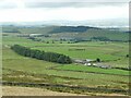
Shelter belt by a tributary of the Hatton Burn
by Stanley Howe geograph for square NO7299 Looking upstream.
|