Your search for images, within 10km of grid reference J3124, in canonical category View, returns
23 images:
( Page 1 2 next >> last ) [refine search]
[quick refine]

|
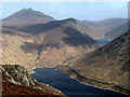
Silent Valley Reservoir
by GARRY HARPER geograph for square J3124 Dist:0.3km Category: Viewpoint On top of Slieve Binnian looking at Silent Valley Reservoir
|

|
A Picnic Spot with A View
by Eric Jones geograph for square J3122 Dist:2.0km south Category: Viewpoint A cleft in the summit tor of Wee Binnian provides the picnicer with an excellent view northwards to Doan, Slieve Loughshannagh and Slieve Meelbeg.
|
|
Silent Valley and Ben Crom from Slievenaglogh
by Rossographer for square J2923 Dist:2.1km west-southwest Category: View A view over the Silent Valley and Ben Crom reservoirs from the summit of Slievenaglogh. Ben Crom mountain is in the centre of picture and Slieve Bearnagh is to the top... (more)
|

|
Devil's Coach
by GARRY HARPER geograph for square J3323 Dist:2.2km east-southeast Category: Viewpoint what a view
|

|
Five yellow diggers
by Rossographer geograph for square J3422 Dist:3.5km east-southeast Category: Countryside feature By a house near Carrick Little in the Mournes.
|

|
Rounding the foot of The Castles
by Eric Jones geograph for square J3427 Dist:4.5km northeast Category: Viewpoint The Castles is a series of tors which are part of the back wall of the Annalong Valley. This point on the path below the Mourne Wall provides the first view of... (more)
|

|
The view northwards from the summit of Thomas's Mountain
by Eric Jones geograph for square J3528 Dist:6.0km northeast Category: Viewpoint The view extends across Dundrum Bay, the Ballykinlar Army ranges, the Lecale Peninsula and Stranford Lough towards the Mull of Galloway.
|

|
View southwards from the col between Millstone Mountain and Thomas's Mountain
by Eric Jones geograph for square J3628 Dist:6.0km northeast Category: Viewpoint The view follows the line of the Glen Fofanny River down to the narrow coastal plain at Bloody Bridge.
|
|
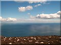
Where the Mountains of Mourne sweep down to the sea
by Eric Jones geograph for square J3627 Dist:6.1km east-northeast Category: Viewpoint This is the view due east from the summit of Crossone. The mountainous profile of the Isle of Man dominates the horizon.
|
|
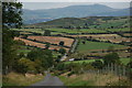
The Kinnahalla Road near Hilltown (2)
by Albert Bridge for square J2630 Dist:7.8km northwest Category: View
This is the Kinnahalla Road from the same vantage point as J2629 : The Kinnahalla Road near Hilltown (1) but looking towards the Hilltown to Bryansford road.
|

|
Probably the best view in Co Down
by GARRY HARPER geograph for square J3232 Dist:7.8km north Category: Viewpoint God`s country
|

|
View north-westwards towards the Shimna Valley
by Eric Jones geograph for square J3431 Dist:7.8km north-northeast Category: Country view The wooded hill in the background is Moneyscalp.
|

|
View south eastwards from the Hilltown Road drive
by Eric Jones geograph for square J3232 Dist:7.9km north Category: View Slieve Commedagh and Shan Slieve form the background behind the forest.
|
|
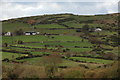
From Bryansford to Hilltown
by Albert Bridge geograph for square J2731 Dist:8.1km north-northwest Category: View
The road from Bryansford to Hilltown starts close to Tollymore forest, climbs through semi-mountainous countryside and then descends towards Hilltown. This view,... (more)
|

|
Roofs of houses on South Promenade from King Street
by Eric Jones geograph for square J3729 Dist:8.3km northeast Category: Roofscape |
Search took 0.01 secs, ( Page 1 2 next >> last ) [refine search]
· Login to view KML, GPX, or RSS versions of these results.Expand Word Statistics
Found these results useful? Please Donate
|