Your search for images, within 10km of grid reference J0120, classifed as Mountains, returns
7 images:
( Page 1 ) [refine search]
[quick refine]
[1 squares within 4km have no or only one photo - can you add more?]
|
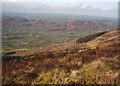
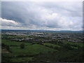
Slieve Gullion: Western Slope
by Ron Murray geograph for square J0120 The photo shows the West Slope of Slieve Gullion which is in the grid square, the lowlands between Mullagbane and Lislea and in the background The Ring of Gullion (Slievenacapple)
|
|
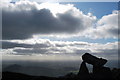
Slieve Gullion
by GARRY HARPER for square J0221 Dist:1.1km northeast Tags: [type:Close Look] On top of Slieve Gullion offers views as far away as Connacht and Dublin Bay in favourable weather conditions.
|

|
Slieve Gullion
by GARRY HARPER geograph for square J0220 Dist:1.1km east On top of Slieve Gullion
|

|
Slieve Gullion
by GARRY HARPER for square J0220 Dist:1.3km east Tags: [type:Inside] A well preserved passage grave which is the highest yet discovered in Ireland.
|
|
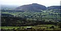
Slieve Gullion: South-West Slope
by Ron Murray geograph for square J0218 Dist:2.2km south-southeast The South-West slope of Slieve Gullion in the grid square, the lowland between Forkhill and Mullaghbane and in the background Croslieve and Slievebrack.
|
|
Clermont Carn.
by Peter Lyons geograph for square J0524 Dist:5.7km northeast Looking towards Clermont Carn and the Irish Republic border
|
|
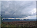
Mourne Mountains from inside the ring of gullion.
by Peter Lyons geograph for square J0524 Dist:5.7km northeast Taken on the summit of Camlough Mountain.
|
Search took 0.01 secs, ( Page 1 ) [refine search]
· Login to view KML, GPX, or RSS versions of these results.Expand Word Statistics
Found these results useful? Please Donate
|