Your search for images, within 10km of grid reference J1120, classifed as River, returns
26 images:
( Page 1 2 next >> last ) [refine search]
[quick refine]

|
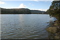
Newry River and Shipping Canal
by Ron Murray geograph for square J1120 Area shown is within Carlingford Lough Area of Special Scientific Interest.
|

|
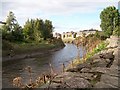
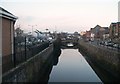
The Newry River at the Victoria Lock
by Albert Bridge geograph for square J1120 Dist:0.4km See J1120 : The Victoria Lock near Newry (1). The Newry River, approaching the lock from the seaward side, at about 3¾ hours before high water (HW). Entrance to the lock is restricted to one hour... (more)
|

|
New navigation markers on the Newry River
by Albert Bridge for square J1119 Dist:1.0km south
For the background to the Newry Ship Canal see J1120 : Victoria locks, Newry ship canal. The navigation marks in the Newry River have fallen into disrepair through lack of use. They are now being... (more)
|
|
The Newry River at Narrow Water
by Albert Bridge geograph for square J1219 Dist:1.4km southeast
See J1219 : Lane through the Ferry Wood near Omeath. This is the Newry River looking towards Newry with Narrow Water castle visible at top right. It has been suggested that a bridge be built here... (more)
|

|
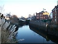
The Clanrye River above Narrow Water Castle
by Eric Jones geograph for square J1219 Dist:1.5km southeast The tall trees and the mountains are in the Irish Republic. On the left a ship can be seen docked at the port of Warrenpoint.
|

|
Narrow Water near Warrenpoint
by Albert Bridge for square J1219 Dist:1.9km southeast Narrow Water seen from the Flagstaff. The Newry Warrenpoint road is on the left and Warrenpoint harbour estate J1318 : Warrenpoint harbour estate is at top right. The Ferry Wood is at middle... (more)
|
|
The Clanrye River from Kilmorey Road
by Eric Jones geograph for square J0825 Dist:5.9km north-northwest |
|
The Clanrye River below Dublin Road Bridge
by Eric Jones geograph for square J0825 Dist:6.0km north-northwest |
|
The Clanrye River and St Mary's Church from Dublin Bridge
by Eric Jones geograph for square J0826 Dist:6.3km north-northwest |

|
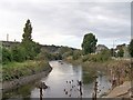
View south along the Newry River from the Ulsterbus depot waiting room
by Eric Jones geograph for square J0826 Dist:6.6km north-northwest The Ulsterbus depot's waiting room spans the River Newry. Its passenger entrance is in The Mall (the street on the left) while the bus forecourt is on the narrow... (more)
|

|
The Clanrye River from The Mall
by Eric Jones geograph for square J0826 Dist:6.6km north-northwest The bus station car park can be seen on the opposite bank.
|
|
View north along the Clanrye/Newry River from the Ulsterbus Station
by Eric Jones geograph for square J0826 Dist:6.7km north-northwest The waiting room of the bus station spans the river.
|

|
Clanrye River
by David Crozier geograph for square J1027 Dist:6.7km north Clanrye River as it crosses B8 Hilltown Road
|

|
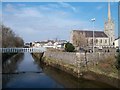
The Clanrye River below of Newry Town Hall
by Eric Jones geograph for square J0826 Dist:6.8km north-northwest The rear of Newry's Town Hall can be seen on the extreme right of the photo.
|
|
Early morning on the Clanrye River
by Eric Jones geograph for square J0826 Dist:6.8km north-northwest This a view in the direction of the red brick Newry Town Hall from Needham Bridge.
|
Search took 0.01 secs, ( Page 1 2 next >> last ) [refine search]
· Login to view KML, GPX, or RSS versions of these results.Expand Word Statistics
Found these results useful? Please Donate
|