Your search for images, within 10km of grid reference J1120, by Ron Murray, returns
10 images:
( Page 1 ) [refine search]
[quick refine]

|
Newry River and Shipping Canal
by Ron Murray geograph for square J1120 Category: River Area shown is within Carlingford Lough Area of Special Scientific Interest.
|

|
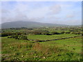
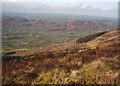
Flagstaff
by Ron Murray geograph for square J1020 Dist:1.0km Category: Hills North-Eastern Slope of hill which forms part of the Ring of Gullion. Carlingford Lough is shown in background
|
|
Fathom Mountain: West Side
by Ron Murray geograph for square J0921 Dist:2.2km west-northwest Category: Grazing land View to Slieve Gullion
|
|
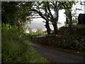
Fathom Mountain: North-East Side
by Ron Murray geograph for square J0922 Dist:2.8km northwest Category: Road scene looking toward Carlingford Lough
|
|
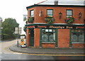
Meigh Village Centre
by Ron Murray geograph for square J0520 Dist:6.1km west Category: Public house Good food and close to Slieve Gullion Forest Park
|

|
Killevy Churches and Graveyard
by Ron Murray geograph for square J0422 Dist:7.6km west-northwest Category: Ancient site Ecclesiastical site founded by St Moninna in the 6th Century. Two churches are on the site one dating from the 10th Century and the other from the 12th Century. A... (more)
|

|
Kilnasaggart Stone
by Ron Murray for square J0614 Dist:7.7km southwest Category: Monument The stone can be dated to about AD700. Carved inscriptions include IN LOC TANIMMARNI TERNOHC MAC CERAN BIC ER CUL PETER APSTEL recording the dedication of the place to... (more)
|

|
Moyry Castle
by Ron Murray geograph for square J0514 Dist:8.2km southwest Category: Castle Moyry Castle, overlooking the strategically important Gap of the North, was built as a military stronghold in 1601 by Lord Mountjoy,
|
|
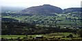
Slieve Gullion: South-West Slope
by Ron Murray geograph for square J0218 Dist:9.2km west-southwest Category: Mountains The South-West slope of Slieve Gullion in the grid square, the lowland between Forkhill and Mullaghbane and in the background Croslieve and Slievebrack.
|
|
Slieve Gullion: Western Slope
by Ron Murray geograph for square J0120 Dist:10.0km west Category: Mountains The photo shows the West Slope of Slieve Gullion which is in the grid square, the lowlands between Mullagbane and Lislea and in the background The Ring of Gullion (Slievenacapple)
|
Search took 0.00 secs, ( Page 1 ) [refine search]
· Login to view KML, GPX, or RSS versions of these results.Expand Word Statistics
Found these results useful? Please Donate
|