Your search for images, within 10km of grid reference J 273 252, classifed as Mountain, returns
28 images:
( Page 1 2 next >> last ) [refine search]
[quick refine]
|
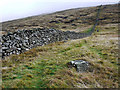
Batt's Wall, Slieve Muck
by Rossographer geograph for square J2725 Looking up Batt's Wall towards the summit of Slieve Muck.
|
|
Ascending Slieve Muck
by Rossographer geograph for square J2825 Dist:1.4km east-southeast Ascending Slieve Muck from Carn Mountain the route follows the Mourne Wall. After a few hundred metres the route along the wall is blocked by a large rocky outcrop so it... (more)
|

|
Pigeon Rock in the Mournes (1)
by Albert Bridge geograph for square J2623 Dist:1.9km south-southwest Pigeon Rock (1755ft) with the White Water J2623 : The White Water near Spelga (1) in the foreground flowing from right to left. See also J2623 : Pigeon Rock in the Mournes (2).
|

|
Pigeon Rock in the Mournes
by HENRY CLARK geograph for square J2623 Dist:1.9km south-southwest Taken from the Moyad Road
|

|
Slieve Muck
by Albert Bridge geograph for square J2722 Dist:2.6km south Slieve Muck (background) seen through one of the thinner parts of Crocknafeola Wood J2722 : Crocknafeola Wood near Attical. The Moyad Road is marked by the drystone wall across the middle of the photo.
|

|
Slievenaglogh
by HENRY CLARK geograph for square J2822 Dist:3.0km south-southeast |
|
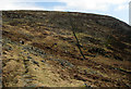
Slievenaglogh
by Rossographer geograph for square J2922 Dist:3.4km south-southeast The start of the ascent on Slievenaglogh. This firstly follows a path before joining with the Mourne Wall which can be seen rising towards the summit.
|

|
Hen Mountain near Hilltown (2)
by Albert Bridge for square J2427 Dist:3.7km west-northwest See J2427 : Hen Mountain near Hilltown. A change of viewpoint (the Kilkeel Road J2528 : The Kilkeel Road near Hilltown to the north east) and change of season the mountain looks exceptionally bleak and barren in mid-winter.
|

|
Ben Crom
by Rossographer for square J3126 Dist:3.9km east-northeast Ben Crom mountain in the Mournes
|

|
Slieve Bearnagh
by Eric Jones for square J3128 Dist:4.8km northeast At 730m, Bearnagh is the most eye-catching of the Mourne peaks, with the look and the feel of a real mountain. This view is taken from the col between Slieve Beg and Cove Mountain.
|

|
The Mourne Wall at the Hare's Gap
by Rossographer geograph for square J3228 Dist:6.2km east-northeast The Mourne Wall heading north from the Hare's Gap towards the summit of Slievenaglogh. There is a slight break in the wall as it encounters a rocky cliff - walkers... (more)
|

|
Slievebug in the Mournes
by HENRY CLARK geograph for square J2519 Dist:6.2km south-southwest |

|
The Mourne Wall, Slieve Commedagh
by Rossographer geograph for square J3428 Dist:7.6km east-northeast Approaching the ascent of Slieve Commedagh from the west. The route to the summit follows the Mourne Wall.
|

|
Slieve Commedagh
by Rossographer for square J3428 Dist:7.7km east-northeast The snow capped Slieve Commedagh as seen from the path running from Carrick Little near Annalong Wood. To the left is part of Cove Mountain and to the right part of Rocky Mountain.
|

|
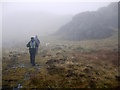
Rocky Mountain viewed from Slieve Beg
by Eric Jones for square J3525 Dist:7.7km east |
Search took 0.01 secs, ( Page 1 2 next >> last ) [refine search]
· Login to view KML, GPX, or RSS versions of these results.Expand Word Statistics
Found these results useful? Please Donate
|