Your search for images, within 10km of grid reference J 273 252, by Rossographer, returns
384 images:
( Page 1 2 3 4 5 6 7 8 ... next >> last ) [refine search]
[quick refine]
|
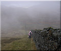
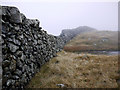
Batt's Wall, Slieve Muck
by Rossographer geograph for square J2725 Category: Mountain Looking up Batt's Wall towards the summit of Slieve Muck.
|
|
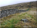
Batt's Wall, Slieve Muck
by Rossographer geograph for square J2725 Dist:0.3km Category: Mountain walls Batt's Wall on the steep descent from Slieve Muck. Spelga Dam can be seen beyond.
|
|
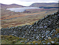
Batt's Wall, Slieve Muck
by Rossographer geograph for square J2725 Dist:0.4km Category: Mountains The gravity defying section of Batt's Wall on the steep descent from Slieve Muck. The wall begins to rise again up to Pigeon Rock Mountain which can be seen in the distance.
|

|
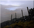
Road and stile near Spelga Dam
by Rossographer geograph for square J2725 Dist:0.5km Category: Stile Nameless road and stile leading to the southern edge of the Spelga Dam reservoir. A popular route for both hikers and anglers, this is accessed from the Slievenaman Road.
|
|
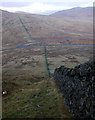
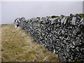
Batt's Wall, Slieve Muck
by Rossographer geograph for square J2725 Dist:0.5km Category: Mountain walls Batt's Wall on the steep descent from Slieve Muck. Spelga Dam can be seen through the mist.
|

|
Bench Mark near Spelga Dam
by Rossographer for square J2725 Dist:0.6km Category: Bench Mark Cut bench mark on a low granite wall beside the Slievenaman Road close to the Spelga Dam.
The mark is 369.80 metres above MSL.
See also... (more)
|
|
Batt's Wall, Slieve Muck
by Rossographer geograph for square J2725 Dist:0.6km Category: Mountain walls Batt's Wall on the steep descent from Slieve Muck.
|

|
The Slievenaman Road in the Mournes
by Rossographer geograph for square J2725 Dist:0.6km Category: B road (Classified B) The B27 Slievenaman Road through the Mourne Mountains.
|

|
Granite marker near Spelga Dam
by Rossographer geograph for square J2725 Dist:0.7km Category: Stone marker One of many granite marker stones running alongside the Slievenaman Road close to the Spelga Dam.
|
|
Batt's Wall, Slieve Muck
by Rossographer geograph for square J2825 Dist:0.7km Category: Mountain walls Batt's Wall on the steep descent from Slieve Muck.
|

|
Sign at Spelga Dam
by Rossographer for square J2625 Dist:0.8km Category: Signs Detail of J2625 : Gate and track at Spelga Dam. The sign is for the benefit of anglers but is heavily pockmarked and looks as though it has been repeatedly hit with ball bearings or something similar.
|
|
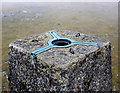
Spider, Slieve Muck Triangulation Pillar
by Rossographer for square J2824 Dist:0.8km Category: Triangulation Pillar Detail on the 'spider' on the Slieve Muck Triangulation Pillar J2824 : Slieve Muck Triangulation Pillar.
The screw cap is sadly missing.
|
|
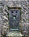
Flush Bracket, Slieve Muck Triangulation Pillar
by Rossographer for square J2824 Dist:0.8km Category: Bench Mark Flush bracket located on Slieve Muck Triangulation Pillar J2824 : Slieve Muck Triangulation Pillar. Despite (or because of) the harsh conditions at the top of the mountain, this is one of the... (more)
|

|
Slieve Muck Triangulation Pillar
by Rossographer geograph for square J2824 Dist:0.8km Category: Triangulation Pillar Triangulation pillar located on the summit of Slieve Muck in the Mourne Mountains. The pillar sits at a height of 673 metres (2198 feet) above MSL and is one of only two... (more)
|
|
The Mourne Wall, Slieve Muck
by Rossographer geograph for square J2825 Dist:0.8km Category: Mountain walls The Mourne Wall on Slieve Muck is different from the rest of the wall as it is not constructed of granite but of a Silurian rock. The construction of this particular... (more)
|
Search took 0.00 secs, ( Page 1 2 3 4 5 6 7 8 ... next >> last ) [refine search]
· Login to view KML, GPX, or RSS versions of these results.Expand Word Statistics
Found these results useful? Please Donate
|