Your search for images, within 10km of grid reference J 362 735, classifed as River, returns
172 images:
( Page 1 2 3 4 5 6 7 8 ... next >> last ) [refine search]
[quick refine]
|
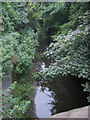
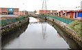
River Connswater, Belfast
by Patrick Brown geograph for square J3673 The River Connswater seen from the Beersbridge Road, Belfast
|
|
The Connswater, Belfast (7)
by Albert Bridge geograph for square J3673 Dist:0.1km Part of the Connswater, at the Flora Street walkway, as it flows under the Beersbridge Road J3673 : Wall, east Belfast (background).
|
|
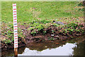
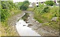
The Knock River, Belfast (11)
by Albert Bridge for square J3673 Dist:0.2km A depth marker in this section of the Knock River J3673 : The Knock River, Belfast (10).
|
|
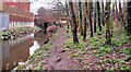
The Knock River, Belfast (10)
by Albert Bridge geograph for square J3673 Dist:0.2km Part of the Knock River, downstream of J3673 : The Connswater, Belfast (7) seen from the footbridge
J3673 : Knock River footbridge, Belfast (2) behind Bloomfield Parade. This stretch of the river is one along which the... (more)
|
|
The Connswater, Belfast (3)
by Albert Bridge geograph for square J3674 Dist:0.5km See J3674 : The Connswater, Belfast (2). The view upstream from the bridge seen in the background of J3674 : The Connswater, Belfast. This was the site of the old Belfast Ropeworks now redeveloped with retail... (more)
|
|
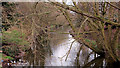
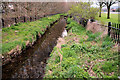
The Knock River, Belfast (3)
by Albert Bridge geograph for square J3673 Dist:0.5km Tags: [place:Belfast] [Knock River (Belfast)] [River] [river banks] [Then and now] See J3673 : The Knock River, Belfast (2). The view downstream from this footbridge J3673 : Footbridge, Belfast. The Dixon Park playing fields are on the left. The area is included in the Connswater Greenway... (more)
|
|
The Knock River, Belfast (2)
by Albert Bridge geograph for square J3673 Dist:0.5km Tags: [place:Belfast] [Knock River (Belfast)] [River] [Then and now] See J3673 : The Knock River, Belfast (1). The view upstream from this footbridge J3673 : Footbridge, Belfast. The Dixon Park playing fields are on the right. The area is included in the Connswater Greenway... (more)
|

|
The Connswater, Belfast
by Albert Bridge geograph for square J3674 Dist:0.6km Tags: [place:Belfast] [Connswater] [subject:river] [River] [Then and now] [tidal river] The Connswater (looking upstream) from the Connswater Bridge. The Ropeworks was ahead and on the right. Continue to J3674 : The Connswater, Belfast (2). J3674 : The Connswater, Belfast - March 2017(4) shows a similar view after... (more)
|
|
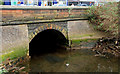
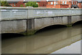
The Connswater, Belfast (11)
by Albert Bridge geograph for square J3674 Dist:0.7km Tags: [top:Rivers, Streams, Drainage] [top:Suburb, Urban fringe] [Belfast] [Connswater] [River] [tidal river] [Tidal variation] The Connswater Bridge, on the Newtownards Road, immediately downstream of the weir J3674 : The Connswater, Belfast (10). The fully-tidal river flows underground J3674 : The Connswater, Belfast (2) before coming back... (more)
|

|
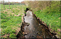
The Knock River, Belfast (1)
by Albert Bridge geograph for square J3673 Dist:0.8km The Knock River rises near Stormont and merges with the Loop River J3672 : The Loop Bridge, Belfast a short distance downstream from here, in Greenville Park, to form the Connswater. The... (more)
|
|
The Connswater, Belfast (4)
by Albert Bridge geograph for square J3674 Dist:0.9km See J3674 : The Connswater, Belfast (3). The tidal Connswater at Connswater Street (looking downstream) with the Holywood Arches Health Centre J3674 : The Holywood Arches health centre, Belfast on the right. Continue to J3674 : The Connswater, Belfast (5).
|

|
The Connswater, Belfast (5)
by Albert Bridge geograph for square J3674 Dist:1.1km north-northwest See J3674 : The Connswater, Belfast (4). The tidal Connswater as it flows (right to left) under Mersey Street.
|
|
The Connswater, Belfast (12)
by Albert Bridge geograph for square J3674 Dist:1.1km north-northwest Tags: [Tidal variation] The tidal part of the Connswater, about 40 minutes before high water, seen from the other side of the Mersey Street bridge J3674 : The Connswater, Belfast (5). J3674 : The Connswater, Belfast (18) shows the bridge at... (more)
|

|
The Connswater, Belfast (6)
by Albert Bridge geograph for square J3674 Dist:1.2km north-northwest The tidal part of the Connswater, looking downstream from the Mersey Street bridge, towards the Sydenham bypass and Victoria Park, approximately 2½ hours after high water Belfast.
|
|
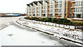
The frozen River Lagan, Belfast (3)
by Albert Bridge geograph for square J3473 Dist:1.4km west-southwest Tags: [Seasonal comparison] See J3474 : The frozen River Lagan, Belfast (2). At the Albert Bridge, with the St Georges Harbour apartments J3473 : Apartments, St George's Harbour, Belfast on the right. Continue to J3473 : The frozen River Lagan, Belfast (4).
|
Search took 0.02 secs, ( Page 1 2 3 4 5 6 7 8 ... next >> last ) [refine search]
· Login to view KML, GPX, or RSS versions of these results.Expand Word Statistics
Found these results useful? Please Donate
|