Your search for images, within 10km of grid reference J 522 536, by Albert Bridge, returns
890 images:
( Page 1 2 3 4 5 6 7 8 ... next >> last ) [refine search]
[quick refine]
[16 squares within 4km have no or only one photo - can you add more?]
|
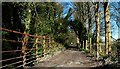
Broad Meadows Lane, Killyleagh
by Albert Bridge geograph for square J5253 Category: Lane Broad Meadows Lane is a public footpath running from the Shrigley Road to the Comber Road (background). The bridge carries the lane over the Dibney River.
|
|
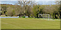
Football ground, Killyleagh (2)
by Albert Bridge geograph for square J5253 Dist:0.3km Tags: [top:Sport, Leisure] [football ground] [Killyleagh] See J5253 : Football ground, Killyleagh (1). The northern end.
|
|
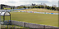
Football ground, Killyleagh (1)
by Albert Bridge geograph for square J5253 Dist:0.4km Tags: [top:Sport, Leisure] [football ground] [Killyleagh] The south western end of The Showgrounds beside the Comber Road. Home to Killyleagh YC football club Link
|
|
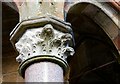
The Shrigley memorial (detail) (1)
by Albert Bridge for square J5153 Dist:0.4km Category: Memorial See J5153 : The Shrigley memorial. The memorial is no longer in prime condition. As shown by this detail of one of the supporting pillars it would benefit from restoration.
|
|
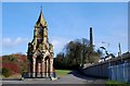
The Shrigley memorial
by Albert Bridge geograph for square J5153 Dist:0.4km Category: Memorial Shrigley developed as a mill village based around a cotton mill built by one John Martin in 1824. The memorial to him was erected in 1871, by grateful villagers, while... (more)
|
|
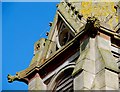
The Shrigley memorial (detail) (2)
by Albert Bridge for square J5153 Dist:0.4km Category: Memorial See J5153 : The Shrigley memorial (detail) (1). It also includes four quasi gargoyles two of which are shown here. They seem to have fared better than the soft plasterwork.
|
|
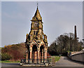
The Shrigley Memorial (2012)
by Albert Bridge geograph for square J5153 Dist:0.4km Tags: [top:People, Events] [top:Village, Rural settlement] [Buildings at risk] [Memorial] [Shrigley] See J5153 : The Shrigley memorial (February 2008). More than four years later the memorial remains untouched and still at risk.
|
|
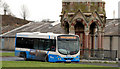
Bus, Shrigley
by Albert Bridge geograph for square J5153 Dist:0.4km Category: Bus Tags: [bus] [Killyleagh] [Shrigley] [Translink] [Ulsterbus] A Wrightbus Solar-bodied Scania about to depart from the Shrigley memorial J5153 : The Shrigley memorial with the 11.10 service to Belfast (Laganside Buscentre) service no 511. The 5... (more)
|
|
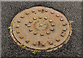
Portadown Foundry manhole cover, Shrigley
by Albert Bridge for square J5153 Dist:0.4km Tags: [top:Industry] [top:Village, Rural settlement] [Foundry product] [Manhole cover] [Portadown Foundry] [Shrigley] Well away from home, a Portadown Foundry J0858 : Portadown Foundry grating cover, Lurgan manhole cover close to the Shrigley Memorial J5153 : The Shrigley memorial.
|
|
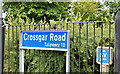
Blue road name sign, Shrigley (July 2017)
by Albert Bridge for square J5153 Dist:0.4km Tags: [top:Roads, Road transport] [type:Close Look] [Road Name Sign] [Shrigley] [subject:sign] Road name sign, with white letters on a reflective blue background, at the Shrigley Road end of the Crossgar Road.
|
|
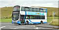
Bus, Shrigley (July 2017)
by Albert Bridge geograph for square J5153 Dist:0.4km Tags: [top:Roads, Road transport] [subject:bus] [bus] [type:Geograph] [Shrigley] [Translink] [Ulsterbus] An Ulsterbus Wright-bodied Volvo (2236 OEZ 7236) leaving the turning circle, at the Shrigley Memorial J5153 : The Shrigley memorial, with the 10.50 to Downpatrick. The stop is on the... (more)
|
|
Mary's stile, Killyleagh
by Albert Bridge for square J5253 Dist:0.5km Tags: [top:People, Events] [top:Religious sites] [Killyleagh] [stile] Marys stile at the entrance to the ruin of Killowen church.
|
|
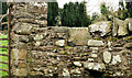
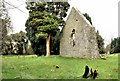
Killowen church, Killyleagh (2)
by Albert Bridge geograph for square J5253 Dist:0.5km Tags: [top:Derelict, Disused] [top:Religious sites] [church (ruined)] [Killyleagh] The ruin seen from the south west.
|
|
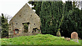
Killowen church, Killyleagh (1)
by Albert Bridge geograph for square J5253 Dist:0.5km Tags: [top:Derelict, Disused] [top:Religious sites] [church (ruined)] [Killyleagh] The ruin seen from the north.
|
|
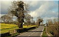
The Comber Road near Killyleagh
by Albert Bridge for square J5254 Dist:0.5km Category: Road The Killyleagh Comber road passes through the drumlins of east Down for much of its length. This is the road as it passes the Mill Hill (left) J5254 : The Mill Hill near Killyleagh.
|
Search took 0.01 secs, ( Page 1 2 3 4 5 6 7 8 ... next >> last ) [refine search]
· Login to view KML, GPX, or RSS versions of these results.Expand Word Statistics
Found these results useful? Please Donate
|