Your search for images, by Philip Cornwall, in reverse Date Submitted order, returns
901 images:
( Page 1 2 3 4 5 6 7 8 ... next >> last ) [refine search]
[quick refine]
|
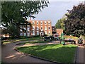
Bridgford Hall
by Philip Cornwall geograph for square SK5837 Tags: [top:City, Town centre] [top:Park and Public Gardens] [top:Public buildings and spaces] [type:Geograph] [subject:hall] Now used as a Registry Office Link
|
|
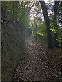
Cobbled footpath skirting edge of Brough Park
by Philip Cornwall geograph for square SJ9856 Tags: [top:City, Town centre] [top:Park and Public Gardens] [top:Paths] [cobbled] [type:Geograph] [subject:path] |
|
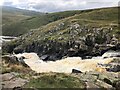
Upper section of Cauldron Snout
by Philip Cornwall geograph for square NY8128 Tags: [top:Paths] [top:Rivers, Streams, Drainage] [top:Uplands] [Cauldron Snout] [type:Geograph] [subject:waterfall] Cauldron Snout is a cascade on the River Tees after it exits from Cow Green Reservoir
|

|
View across moorland to Cow Green Reservoir
by Philip Cornwall geograph for square NY8130 Tags: [top:Lakes, Wetland, Bog] [top:Uplands] [top:Water resources] [type:Geograph] [subject:reservoir] Looking across a fence in the general direction of the dam
|

|
Road across Cow Green Dam
by Philip Cornwall geograph for square NY8129 Tags: [top:Lakes, Wetland, Bog] [top:Roads, Road transport] [top:Uplands] [top:Water resources] [Dam] [type:Geograph] [subject:road] |

|
Road running alongside Cow Green Reservoir
by Philip Cornwall geograph for square NY8129 Tags: [top:Lakes, Wetland, Bog] [top:Roads, Road transport] [top:Uplands] [top:Water resources] [type:Geograph] [subject:road] Looking north from a point near to the dam.
|
|
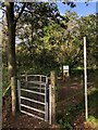
Gate at Southeastern corner of Brereton Heath Nature Reserve
by Philip Cornwall geograph for square SJ7964 Tags: [top:Heath, Scrub] [top:Lowlands] [top:Paths] [top:Woodland, Forest] [Dane Valley Way] [subject:gate] [type:Geograph] The Dane Valley Way enters the nature reserve at this point
|
|
Stable Buildings, East of Brereton Heath Nature Reserve
by Philip Cornwall geograph for square SJ8064 Tags: [top:Lowlands] [top:Sport, Leisure] [top:Woodland, Forest] [type:Geograph] [subject:stable] [stable block] Taken from the restricted byway that runs down the eastern edge of the reserve
|
|
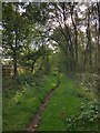
Restricted byway at Eastern margin of Brereton Heath Nature Reserve
by Philip Cornwall geograph for square SJ8065 Tags: [top:Lowlands] [top:Paths] [top:Woodland, Forest] [type:Geograph] [Nature Reserve] [subject:path] |
|
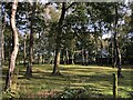
Footpath at Northern margin of Brereton Heath nature reserve
by Philip Cornwall geograph for square SJ7965 Tags: [top:Lowlands] [top:Paths] [top:Woodland, Forest] [type:Geograph] [Nature Reserve] [subject:path] |
|
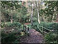
Footbridge over drainage channel, Lower Moss Wood
by Philip Cornwall geograph for square SJ7875 Tags: [top:Educational sites] [top:Lowlands] [top:Paths] [top:Rivers, Streams, Drainage] [subject:bridge] [type:Geograph] |
|
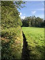
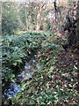
Drainage Channel, Lower Moss Wood
by Philip Cornwall geograph for square SJ7875 Tags: [top:Educational sites] [top:Lowlands] [top:Rivers, Streams, Drainage] [top:Woodland, Forest] [subject:drain] [type:Geograph] Lower Moss Wood is the site of an Educational Nature Reserve and Wildlife Hospital Link
|
|
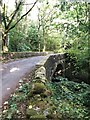
Bridge carrying minor road over Bow Lee Beck
by Philip Cornwall geograph for square NY9028 Tags: [top:Roads, Road transport] [top:Uplands] [top:Woodland, Forest] [subject:bridge] [type:Geograph] |
|
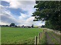
View from track southeast of Bowlees
by Philip Cornwall for square NY9028 Tags: [top:Farm, Fishery, Market Gardening] [top:Paths] [top:Roads, Road transport] [top:Uplands] [type:Cross Grid] Bowlees Farm is near the centre of the picture
|

|
Footpath approaching Bank Cottage
by Philip Cornwall geograph for square NY9027 Tags: [top:Paths] [top:Uplands] [top:Woodland, Forest] [subject:cottage] [type:Geograph] |
Search took 0.00 secs, ( Page 1 2 3 4 5 6 7 8 ... next >> last ) [refine search]
· Login to view KML, GPX, or RSS versions of these results.Found these results useful? Please Donate
|