Your search for images, by Andrew Whale, in reverse Date Submitted order, returns
721 images:
( Page 1 2 3 4 5 6 7 8 ... next >> last ) [refine search]
[quick refine]

|
The stream and footbridge just above Trollers Ghyll
by Andrew Whale geograph for square SE0762 Tags: [top:Paths] [top:Rivers, Streams, Drainage] [top:Uplands] [subject:stream] The footpath descends the small rockface on the other side of the stream.
|

|
Looking south, down Trollers Ghyll
by Andrew Whale geograph for square SE0662 Tags: [top:Rivers, Streams, Drainage] [top:Uplands] [subject:valley] On this occasion the ghyll was dry, with the stream disappearing underground just north of here.
|

|
The path leading to Gate Cote Scar
by Andrew Whale geograph for square SD9672 Tags: [top:Paths] [top:Rocks, Scree, Cliffs] [top:Uplands] [subject:path] The path reaches a small cutting in the scar, where a slight scramble is required in order to get to the top.
|

|
Descending Park Scar
by Andrew Whale geograph for square SD9372 Tags: [top:Paths] [top:Rocks, Scree, Cliffs] [top:Uplands] [subject:path] The path here is quite steep and requires careful navigation.
|

|
Arkle Beck
by Andrew Whale geograph for square NZ0201 Tags: [top:Rivers, Streams, Drainage] [top:Uplands] [subject:stream] Here the footpath runs alongside Arkle Beck and offers fine views of the stream.
|

|
Footbridge over Slei Gill
by Andrew Whale geograph for square NZ0102 Tags: [top:Paths] [top:Rivers, Streams, Drainage] [top:Uplands] [subject:bridge] This footbridge crosses Slei Gill just before it joins Arkle Beck.
|

|
Inside Booze Wood Tunnel
by Andrew Whale for square NZ0102 Tags: [top:Paths] [top:Quarrying, Mining] [top:Uplands] [subject:tunnel] A relic of the lead mining industry.
|
|
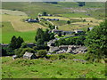
The hamlet of Langthwaite
by Andrew Whale geograph for square NZ0002 Tags: [top:Uplands] [top:Village, Rural settlement] [subject:village] As seen from the road leading to Booze.
|

|
The ford and footbridge over Slei Gill
by Andrew Whale geograph for square NZ0102 Tags: [top:Paths] [top:Rivers, Streams, Drainage] [top:Roads, Road transport] [top:Uplands] [subject:ford] Slei Gill joins Arkle Beck just south of here.
|

|
The path descending Fremington Edge
by Andrew Whale geograph for square NZ0202 Tags: [top:Derelict, Disused] [top:Paths] [top:Quarrying, Mining] [top:Rocks, Scree, Cliffs] [top:Uplands] [subject:path] Here there is evidence of extensive lead mining activity. The hamlet of Booze can be seen in the distance.
|

|
One of several cairns on Fremington Edge
by Andrew Whale geograph for square NZ0202 Tags: [top:Heath, Scrub] [top:Rocks, Scree, Cliffs] [top:Uplands] [subject:cairn] |

|
A crumbling drystone wall
by Andrew Whale geograph for square NZ0301 Tags: [top:Heath, Scrub] [top:Paths] [top:Uplands] [subject:wall] The stile is now redundant.
|

|
The view along Fremington Edge
by Andrew Whale geograph for square NZ0301 Tags: [top:Rocks, Scree, Cliffs] [top:Uplands] [subject:slope] Arkengarthdale can be seen in the distance.
|

|
A stile literally on the edge of Fremington Edge
by Andrew Whale geograph for square NZ0301 Tags: [top:Paths] [top:Rocks, Scree, Cliffs] [top:Uplands] [subject:stile] Care to be taken here, as the stile is rather wobbly. The old drystone wall has been replaced with stock fencing, but even this is in a very sorry state of repair.
|

|
An old mine shaft
by Andrew Whale geograph for square NZ0400 Tags: [top:Derelict, Disused] [top:Moorland] [top:Quarrying, Mining] [top:Uplands] [subject:mine shaft] More information here NZ0400 : North String Man-way, Jingle Pot Mines.
|
Search took 0.00 secs, ( Page 1 2 3 4 5 6 7 8 ... next >> last ) [refine search]
· Login to view KML, GPX, or RSS versions of these results.Found these results useful? Please Donate
|