Your search for images, by Duncan Grey, in reverse Date Submitted order, returns
712 images:
( Page 1 2 3 4 5 6 7 8 ... next >> last ) [refine search]
[quick refine]
|
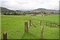
Straloch from West Balnald Cottage
by Duncan Grey geograph for square NO0463 Tags: [top:Lowlands] |

|
Bridge and Stairs at Rannoch Station
by Duncan Grey geograph for square NN4257 Tags: [top:Railways] |

|
Brandon Lock and weir
by Duncan Grey geograph for square TL7786 Tags: [top:Flat landscapes] [top:Rivers, Streams, Drainage] [top:Water resources] The lock is to the right (max length 45 foot) and quite a steep angle of approach for lengthy narrow boats, made worse in this case by duckweed. The weir is to the left,... (more)
|

|
Crab apples naturally collected
by Duncan Grey geograph for square TL0638 Tags: [top:Lowlands] [top:Woodland, Forest] The Greensands Path has plenty of interest, but this was a surprising feature - a gully where the path is worn and where crab apples falling from the tree above collect... (more)
|

|
Houghton House and view to the west
by Duncan Grey geograph for square TL0339 Tags: [top:Lowlands] [top:Park and Public Gardens] Houghton House was built in the 17th century as an elaborate hunting lodge. The house was eventually dismantled by the fifth Duke of Bedford in 1794 because he had to let... (more)
|

|
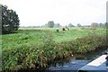
Konik Ponies at Wicken Fen
by Duncan Grey geograph for square TL5570 Tags: [top:Flat landscapes] [top:Rivers, Streams, Drainage] Taken in a trip up the Lode. These undomesticated ponies forage for themselves and maintain a variety of habitats in the fen.
|

|
Reach Lode Bridge
by Duncan Grey geograph for square TL5567 Tags: [top:Rivers, Streams, Drainage] View from the Lode heading away from Reach.
|

|
Moorings at Reach Lode
by Duncan Grey geograph for square TL5666 Tags: [top:Canals] [top:Rivers, Streams, Drainage] These moorings are at the north edge of the village of Reach. This is the limit of navigation, with sufficient turning room for a 60 foot boat (if you don't mind... (more)
|

|
Moorings at Reach
by Duncan Grey geograph for square TL5666 Tags: [top:Canals] Reach Lode terminates at Reach village at the bottom of The Hythe. This view is from a grassy little park with a bench.
|
|
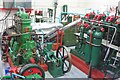
Engines at the Museum of Fenland Drainage, Prickwillow
by Duncan Grey for square TL5982 Category: Pumping station Tags: [type:Inside] Interior view. The engine on the right is a Mirrlees, Bickerton & Day 5-cylinder 4 Stroke Blast-Injection Diesel Engine installed in 1924. The engine on the right is... (more)
|

|
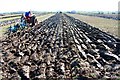
Ploughing Match at Green Farm, Prickwillow
by Duncan Grey geograph for square TL5982 Category: Field The biennial ploughing match extends for a quarter mile across the flat fields of Green Farm. Farmers compete for straight furrows using traditional tractors and ploughs.
|
|
Ploughing Match at Green Farm, Prickwillow
by Duncan Grey geograph for square TL6082 Category: Field This biennial match, accompanied by music and stalls, is a competition for scores of farmers using traditional ploughing gear and old tractors.
|
|
The Pepperpot
by Duncan Grey geograph for square TL6378 Category: Windpump This eight-sided building is the base of one of the original wind powered pumping engines - one of the few remaining examples.
|
|
Small pump and memorial to C H Spurgeon
by Duncan Grey geograph for square TL6575 Category: Commemorative stone The river here was once used for baptism by total immersion. This memorial tablet on the banks of the river Lark is accessible only via the river or across private land.... (more)
|

|
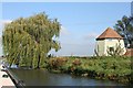
Chear Fen Pumping Station
by Duncan Grey geograph for square TL4971 Category: Pumping station Also outbuildings, seen from the Great Ouse River or The Old West River between Stretham Old Bridge and Twenty Pence Marina.
|
Search took 0.00 secs, ( Page 1 2 3 4 5 6 7 8 ... next >> last ) [refine search]
· Login to view KML, GPX, or RSS versions of these results.Found these results useful? Please Donate
|