Your search for images, by Philip Barker, in reverse Date Submitted order, returns
2,189 images:
( Page 1 2 3 4 5 6 7 8 ... next >> ) [refine search]
[quick refine]

|
Moorland near Hope Head
by Philip Barker geograph for square NY9544 Category: Moorland scene This photograph shows a view of the moorland scenery close to the dismantled railway track near to Hope Head (just south-east of Bolt's law). The sheepfold located... (more)
|
|
Riddings Farm
by Philip Barker geograph for square SE0299 Category: Farm buildings This photograph shows a view of Riddings Farm as seen from the public footpath that runs just to the north of its location. A part of the village of Reeth can be seen... (more)
|

|
Footpath near Thirns
by Philip Barker geograph for square SE0199 Category: Footpath This photograph shows a view of a section of the public footpath that runs between Thirns (behind the photographer) and Arkle Beck (ahead). The picture was taken looking... (more)
|
|
Bridleway near Thirns
by Philip Barker geograph for square SE0099 Category: Bridleway This photograph shows a view of a section of the public bridleway that runs between Fore Gill gate (behind the photographer) and Thirns (ahead). The picture was taken... (more)
|

|
Bridleway near Cleasby
by Philip Barker geograph for square NZ0000 Category: Bridleway This photograph shows a view of the public bridleway and footpath that runs between Fore Gill Gate (behind the photographer) and Thirns (ahead). The picture was taken... (more)
|

|
Fore Gill Gate
by Philip Barker geograph for square NY9900 Category: Gated entrance This photograph shows a view of Fore Gill Gate as seen from the public bridleway that runs between the gate and Thirns (behind the photographer). The minor road that runs... (more)
|

|
Boundary wall in Fore Gill
by Philip Barker geograph for square NY9901 Category: Boundary wall This photograph shows a view of the boundary wall that runs through Fore Gill.
The picture was taken looking in an east-north-easterly direction towards Raw.
|
|
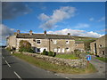
Terraced cottages in Arkle Town
by Philip Barker geograph for square NZ0001 Category: Cottages This photograph shows a view of some terraced cottages in Calva View in the small village of Arkle Town. The minor road that runs between Reeth (behind the photographer)... (more)
|

|
Public bridleway near Low Moor
by Philip Barker geograph for square NZ0003 Category: Bridleway This photograph shows a view of a section of the public bridleway that runs between Windegg Lane (ahead) and Low Moor (behind the photographer). Arkengarthdale is visible... (more)
|

|
Moorland building near Slack Wife Gill
by Philip Barker geograph for square NZ0104 Category: Building This photograph shows a view of a moorland building that is located just to the west of Slack Wife Gill. The picture was taken looking in a south-easterly direction... (more)
|

|
Track junction near Blea Gill
by Philip Barker geograph for square NZ0204 Category: Track junction This photograph shows a view of a track junction near Blea Gill. The track to the right leads off in the direction of Booze Moor while the track to the left is used to... (more)
|

|
Moresdale Road near Hanging Crag
by Philip Barker geograph for square NZ0304 Category: Track This photograph shows a view of the track and bridleway that runs between Schoolmaster Pasture (behind the photographer) and St Andrew's Cross (ahead). The picture... (more)
|

|
Moresdale Road near Fair Seat Hill
by Philip Barker geograph for square NZ0404 Category: Track This photograph shows a view of the track and bridleway that runs between Schoolmaster Pasture (behind the photographer) and St Andrew's Cross (ahead). The picture... (more)
|

|
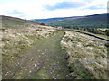
Bridleway near Schoolmaster Pasture
by Philip Barker geograph for square NZ0503 Category: Track This photograph shows a view of a section of the track and bridleway that runs between Windegg Lane (behind the photographer) and Schoolmaster Pasture (ahead). The... (more)
|

|
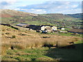
Farm buildings at Holgate
by Philip Barker geograph for square NZ0603 Category: Farm buildings This photograph shows a view of some of the farm buildings at Holgate. The picture was taken looking in a north-north-westerly direction towards West House.
|
Search took 0.00 secs, ( Page 1 2 3 4 5 6 7 8 ... next >> ) [refine search]
· Login to view KML, GPX, or RSS versions of these results.Found these results useful? Please Donate
|