Your search for images, by john shortland, in reverse Date Submitted order, returns
131 images:
( Page 1 2 3 4 5 6 7 8 ... next >> last ) [refine search]
[quick refine]

|
Chantry House, Henley-on-Thames
by john shortland for square SU7682 Tags: [top:Business, Retail, Services] [top:City, Town centre] [top:Historic sites and artefacts] [top:Public buildings and spaces] [16th century] [ancient] [brick] [subject:building] [chantry] [type:Close Look] [Henley-on-Thames] [historic] [house] [overhang] [Parish Room] [River Thames] [school] [tomber] [town] Built in the 15th century as a trading post close to the River Thames, it later became a school and is now used as a parish meeting room. The ground floor has been... (more)
|

|
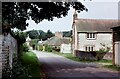
Barn at Fingest Farm
by john shortland geograph for square SU7791 Tags: [top:Farm, Fishery, Market Gardening] [top:Village, Rural settlement] [18th century] [19th century] [subject:barn] [barn] [brick] [county:Buckinghamshire] [building] [Chiltern Hills] [Chilterns] [Farm] [Farming] [Fingest] [type:Geograph] [listed building] [Timber] Part 18th, part 19th century barn constructed of brick and timber with old tiles situated in the village of Fingest. Grade II listed. Fingest is a small village... (more)
|

|
The Chequers Public House, Fingest
by john shortland geograph for square SU7791 Tags: [top:Business, Retail, Services] [top:Sport, Leisure] [top:Village, Rural settlement] [county:Buckinghamshire] [Chequers] [Chiltern Hills] [Chilterns] [Fingest] [type:Geograph] [subject:inn] [Inn] [pub] [public house] [village] Wayside inn, opposite the church in the Chiltern village of Fingest. Built in the early 1700s it is a listed building, Grade II
|

|
The Meandering River Glyme at Radford Bridge
by john shortland geograph for square SP4023 Tags: [top:Farm, Fishery, Market Gardening] [top:Geological interest] [top:Grassland] [top:Lowlands] [top:Rivers, Streams, Drainage] [banks] [bridge] [Farm] [type:Geograph] [Glyme] [meadow] [oxfordshire] [poplar] [Radford] [subject:river] [River] [Salix] [trees] [valley] [willow] Old maps show the river as straight which is why most of the willows stand away from the river's edge and in a straight line. I believe the meanders were created... (more)
|

|
Crossing the East Lyn River at Brendon
by john shortland geograph for square SS7648 Tags: [top:Boundary, Barrier] [top:Housing, Dwellings] [top:Rivers, Streams, Drainage] [top:Roads, Road transport] [top:Sport, Leisure] [top:Village, Rural settlement] [subject:bridge] [type:Geograph] Exmoor National Park. A marker on the bridge shows the boundary between the parishes of Brendon & Countisbury.
|
|
The approach to Shirburn Castle
by john shortland geograph for square SU6995 Tags: [top:Country estates] [top:Housing, Dwellings] [top:Village, Rural settlement] [subject:cottages] [type:Geograph] An old photograph dating back to 1979
|
|
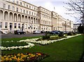
Municipal Offices, Cheltenham
by john shortland geograph for square SO9422 Tags: [top:City, Town centre] [top:Park and Public Gardens] [top:Public buildings and spaces] [subject:building] [type:Geograph] Cheltenham, a Spa town of Regency buildings and picturesque parks in the west of England
|
|
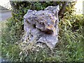
Ancient Marker Stone
by john shortland for square SP3127 Tags: [top:City, Town centre] [top:Geological interest] [top:Historic sites and artefacts] [top:Rocks, Scree, Cliffs] [type:Close Look] [subject:stone] Situated in the centre of Chipping Norton, this ancient marker stone's origin or purpose is unknown
|
|
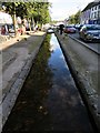
Main Street, Bunclody, Co. Wexford
by john shortland geograph for square S9156 Tags: [top:Village, Rural settlement] [car] [type:Geograph] [Ireland] [pedestrian] [River] [shopping] [subject:stream] [stream] [street] [trees] [village centre] |

|
Roundstone, Co. Galway
by john shortland geograph for square L7240 |

|
Spring in the Chilterns
by john shortland for square SU7591 Category: Country scene Tags: [top:Grassland] [top:Woodland, Forest] [cherry blossom] [Chiltern Hills] [Chilterns] [type:Cross Grid] [lambs] [bucket:Landscape] [wild cherry] Ewes with their lambs and the first wild cherry blossom in this peaceful Chiltern scene.
|

|
The Search for the Holy Grail (3)
by john shortland for square SJ6128 Category: Stained glass window Tags: [da vinci code] [Hodnet] [life of mary magdalene] [Parish church] [Parish Church of St Luke] [county:Shropshire] [St Luke] The parish church of St Luke, Hodnet has recently become world famous because of its connections with the Da Vinci Code. This window illustrates scenes from the life of... (more)
|
|
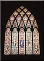
The Search for the Holy Grail (2)
by john shortland for square SJ6128 Category: Stained glass window Tags: [bucket:CloseCrop] [bucket:Closeup] [da vinci code] [Hodnet] [bucket:Indoor] [bucket:Informative] [north aisle] [Parish Church of St Luke] [Shropshire] [St Luke] The parish church of St Luke, Hodnet has recently become world famous because of its connections with the Da Vinci Code. This is the north aisle window.
SJ6128 : The Search for the Holy Grail (1)
SJ6128 : The Search for the Holy Grail (3)
|
|
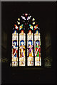
The Search for the Holy Grail (1)
by john shortland for square SJ6128 Category: Stained glass window Tags: [top:Religious sites] [bucket:Closeup] [da vinci code] [Hodnet] [bucket:Indoor] [bucket:Informative] [Parish Church of St Luke] [Shropshire] [south aisle] [St Luke] The parish church of St Luke, Hodnet has recently become world famous because of its connections with the Da Vinci Code. This is the south aisle window.
SJ6128 : The Search for the Holy Grail (2)
SJ6128 : The Search for the Holy Grail (3)
|

|
Hodnet Hall: the South Front
by john shortland geograph for square SJ6128 Category: Country estate Tags: [top:Country estates] [gardens] [gravel path] [Heber Percy] [Hodnet Hall] [house] [lawns] [Shropshire] [South] [steep banks] The steep banks of the lawns fall away to the lake below and are separated from the house by a wide gravel path.
|
Search took 0.00 secs, ( Page 1 2 3 4 5 6 7 8 ... next >> last ) [refine search]
· Login to view KML, GPX, or RSS versions of these results.Found these results useful? Please Donate
|