Your search for images, within 10km of grid reference H 198 707, returns
2,840 images:
( Page 1 2 3 4 5 6 7 8 ... next >> ) [refine search]
[quick refine]
[5 squares within 4km have no or only one photo - can you add more?]
|
Lugmore Townland
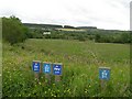
by Kenneth Allen geograph for square H1970 Category: Countryside Looking in the direction of Cruntully
|
|
Lugmore
by Kenneth Allen geograph for square H1970 Category: Countryside The national Cycling route passes through here
|
|
Lugmore
by Kenneth Allen geograph for square H1970 Category: Countryside Castlederg to the left and Drumskinney Stone Circles to the left.
|
|
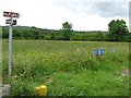
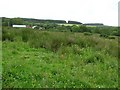
Meentullyclogh Townland
by Kenneth Allen geograph for square H1970 Dist:0.1km Tags: [top:Lowlands] [countryside] Looking WNW
|

|
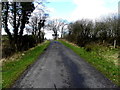
Road at Meentullyglough
by Kenneth Allen geograph for square H1970 Dist:0.2km Tags: [top:Roads, Road transport] [country road] Heading NNE
|

|
Drumskinny alignment Drumskinny Road
by Jo and Steve Turner geograph for square H2070 Dist:0.2km Tags: [top:Historic sites and artefacts] [subject:ancient site] The ancient monument came under the charge of the Ministry of Finance in 1934. Poor drainage inhibited inspection by visitors and in 1962 measures to improve the site... (more)
|

|
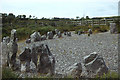
Drumskinny Stone Circle
by Kenneth Allen geograph for square H2070 Dist:0.2km Tags: [top:Historic sites and artefacts] [stone circle] Looking west
|

|
A corner of the Drumskinny Stone Circle
by Oliver Dixon geograph for square H2070 Dist:0.2km Category: Stone circle Showing the alignments of stones in one corner.
|

|
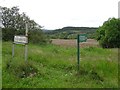
Signpost to Drumskinny Stone Circle
by Kenneth Allen geograph for square H2070 Dist:0.2km Tags: [top:Historic sites and artefacts] [top:Roads, Road transport] [signpost] Pointing south from a lay-by along Rotten Mountain Road
Spelt as Drumskinney here H1970 : Montaighroe Road, Drumskinny
|

|
Drumskinny stone circle and cairn, Drumskinny Road
by Jo and Steve Turner geograph for square H2070 Dist:0.2km Tags: [top:Historic sites and artefacts] [subject:ancient site] The ancient monument came under the charge of the Ministry of Finance in 1934. Poor drainage inhibited inspection by visitors and in 1962 measures to improve the site... (more)
|

|
Drumskinny Stone Circle and Alignment
by Kenneth Allen geograph for square H2070 Dist:0.2km Category: Stone circle Nothing much changed since Dr Nelson's visit.
|
|
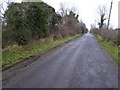
Road at Drumskinny
by Kenneth Allen geograph for square H1970 Dist:0.2km Tags: [top:Roads, Road transport] [country road] Heading west
|
|
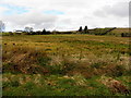
View near Dumskinney Stone circles
by Kenneth Allen geograph for square H2070 Dist:0.3km Category: Countryside It is in the Meentullyclough district
|
|
Drumskinny Stone Circle and Alignment
by Dr Charles Nelson geograph for square H2070 Dist:0.3km Category: Stone circle The alignment of 24 stones extends south from the circle which is 12.8m in diameter and originally had 39 stones.
|
|
Road at Meenmullyclogh
by Kenneth Allen geograph for square H1971 Dist:0.3km Category: Country road Heading to Castlederg
|
Search took 0.00 secs, ( Page 1 2 3 4 5 6 7 8 ... next >> ) [refine search]
· Login to view KML, GPX, or RSS versions of these results.Expand Word Statistics
Found these results useful? Please Donate
|