Your search for images, within 10km of grid reference J1120, returns
8,422 images:
( Page 1 2 3 4 5 6 7 8 ... next >> ) [refine search]
[quick refine]

|
Newry River and Shipping Canal
by Ron Murray geograph for square J1120 Category: River Area shown is within Carlingford Lough Area of Special Scientific Interest.
|

|
Narrow Water Quarry from Flagstaff Viewpoint
by Eric Jones for square J1120 Dist:0.2km Tags: [top:Quarrying, Mining] [top:Woodland, Forest] [type:Cross Grid] |

|
Narrow Water quarry near Newry
by Albert Bridge for square J1120 Dist:0.2km Category: Quarry Narrow Water quarry seen from the Flagstaff. Now re-opened after a period of closure. It is not quite so conspicuous from ground level. The Newry Warrenpoint road is... (more)
|

|
Narrow Water Quarry viewed from the Fathom Line Road
by Eric Jones geograph for square J1120 Dist:0.2km Tags: [top:Estuary, Marine] [top:Quarrying, Mining] [top:Woodland, Forest] [type:Geograph] The A2 dual carriageway road runs behind the line of whins on the Co Down side of the Newry River. The quarry is also known as the Big Wood Quarry. Owned by Clady... (more)
|

|
Narrow Water stone quarry viewed from Flagstaff
by Eric Jones for square J1120 Dist:0.3km Tags: [top:Quarrying, Mining] [top:Woodland, Forest] [type:Cross Grid] Albert Bridge's photo of 2007 shows what the quarry looked like a decade or so ago. The quarry is also known as the Big Wood Quarry. Owned by Clady Quarries it... (more)
|
|
|
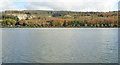
The Narrow Water Forest viewed across the Newry River
by Eric Jones geograph for square J1120 Dist:0.3km Tags: [top:Rivers, Streams, Drainage] [top:Woodland, Forest] [type:Geograph] |
|
Narrow Water Quarry viewed across the Newry River
by Eric Jones for square J1120 Dist:0.3km Tags: [top:Quarrying, Mining] [top:Rivers, Streams, Drainage] [top:Woodland, Forest] [type:Cross Grid] |

|
The entrance to Big Wood Quarry from the A2 Warrenpoint Road Dual Carriageway
by Eric Jones for square J1120 Dist:0.3km Tags: [top:Quarrying, Mining] [top:Roads, Road transport] [type:Cross Grid] The image was taken from the Flagstaff View Point.
J1120 : Road leading to stone quarry in Narrow Water Forest
|

|
The Newry River at low tide
by Eric Jones for square J1120 Dist:0.3km Tags: [top:Estuary, Marine] [top:Quarrying, Mining] [top:Rivers, Streams, Drainage] [top:Woodland, Forest] Big Wood Quarry can be seen in the background.
|

|
Narrow Water Woods from the Fathom Line
by Eric Jones geograph for square J1120 Dist:0.3km Tags: [top:Estuary, Marine] [top:Rivers, Streams, Drainage] [top:Woodland, Forest] [type:Geograph] The river is much reduced by a combination of low tide and well below average rainfall.
|

|
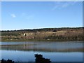
View across the Newry River to Big Wood Quarry at Narrow Water
by Eric Jones for square J1120 Dist:0.3km Tags: [top:Quarrying, Mining] [top:Rivers, Streams, Drainage] [top:Woodland, Forest] This aggregate quarry is located above the A2 in the Narrow Water Forest.
|

|
Entrance to Big Wood Quarry off the A2
by Eric Jones geograph for square J1120 Dist:0.3km Tags: [top:Docks, Harbours] [top:Estuary, Marine] [top:Quarrying, Mining] [top:Roads, Road transport] In the foreground are navigation markers on the Newry River.
|
|
Big Wood Quarry on the Co Down side of the Newry River
by Eric Jones geograph for square J1120 Dist:0.3km Tags: [top:Estuary, Marine] [top:Quarrying, Mining] [top:Woodland, Forest] This stone quarry, also known as Narrow Water Quarry, is located in Narrow Water Wood.
J1120 : Narrow Water quarry near Newry
|

|
Channel marker in the Newry River
by Eric Jones geograph for square J1120 Dist:0.3km Tags: [top:Docks, Harbours] [top:Estuary, Marine] The green spar marks the starboard side of the channel.
|
|
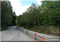
Road leading to stone quarry in Narrow Water Forest
by Eric Jones geograph for square J1120 Dist:0.3km Category: Quarry road |
Search took 0.01 secs, ( Page 1 2 3 4 5 6 7 8 ... next >> ) [refine search]
· Login to view KML, GPX, or RSS versions of these results.Expand Word Statistics
Found these results useful? Please Donate
|