Your search for images, within 10km of grid reference J 273 252, returns
9,143 images:
( Page 1 2 3 4 5 6 7 8 ... next >> ) [refine search]
[quick refine]
|
Batt's Wall, Slieve Muck
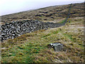
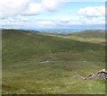
by Rossographer geograph for square J2725 Category: Mountain Looking up Batt's Wall towards the summit of Slieve Muck.
|

|
Batt's Wall on the western face of Slieve Muck
by Eric Jones geograph for square J2725 Dist:0.1km Tags: [top:Boundary, Barrier] [top:Uplands] This wall, a section of a much larger wall extending across the Western Mournes, was built as a famine relief project by the tenants of Sir Narcissus Batt, owner of the... (more)
|

|
Wetland grazings - sheep grazing near the source of the River Bann
by Eric Jones geograph for square J2725 Dist:0.1km Tags: [top:Farm, Fishery, Market Gardening] [top:Lakes, Wetland, Bog] [top:Rivers, Streams, Drainage] [top:Uplands] |

|
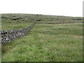
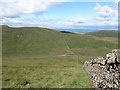
Batt's Wall descending the slopes of Slieve Muck
by Eric Jones geograph for square J2725 Dist:0.1km Tags: [top:Boundary, Barrier] [top:Roads, Road transport] [top:Uplands] This image was taken from the old road. The B27 lies hidden in the middle ground.
|

|
Batt's Wall descending the western slopes of Slieve Muck to reach the B27
by Eric Jones geograph for square J2725 Dist:0.1km Tags: [top:Boundary, Barrier] [top:Roads, Road transport] [top:Uplands] This wall was built during the Great Famine as a social relief measure by the landowner the exquisitely named Sir Narcissus Batt of Purdysburn nr Belfast, It continues... (more)
|

|
Batt's Wall reaching the Bann-White Water watershed at the col
by Eric Jones geograph for square J2725 Dist:0.2km Tags: [top:Boundary, Barrier] [top:Rivers, Streams, Drainage] [top:Uplands] On the other side of the B27 the wall ascends Pigeon Rock Mountain.
|

|
Blackface red, white and blue marked Mourne sheep grazing above the Moyad Road
by Eric Jones geograph for square J2725 Dist:0.2km Tags: [top:Farm, Fishery, Market Gardening] [top:Grassland] [top:Uplands] [top:Water resources] [top:Woodland, Forest] The grass here is harsh and suitable only for sheep and hardy store cattle. The conifers in the background is a shelter belt on the north-eastern edge of the Spelga Reservoir.
|
|
Batt's Wall on the northern slopes of Slieve Muck
by Eric Jones geograph for square J2725 Dist:0.2km Tags: [top:Boundary, Barrier] [top:Uplands] |
|
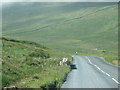
The Moyad Road (B27) descending towards Atticall
by Eric Jones geograph for square J2725 Dist:0.2km Tags: [top:Roads, Road transport] [top:Uplands] |
|
Path descending along the line of Batt's Wall
by Eric Jones geograph for square J2725 Dist:0.2km Tags: [top:Uplands] There is sketchy path leading down to the parking area on the old Hilltown Road off the Moyad Road.
|

|
Rock outcrops on the path ascending along Batt's Wall
by Eric Jones geograph for square J2725 Dist:0.2km Tags: [top:Boundary, Barrier] [top:Rocks, Scree, Cliffs] [top:Uplands] In descent and in misty weather these outcrops can be an obstacle to rapid movement.
|

|
Batt's Wall crossing the Moyad Road
by Eric Jones geograph for square J2725 Dist:0.2km Tags: [top:Boundary, Barrier] [top:Roads, Road transport] [top:Uplands] This wall was built to enclose the Batt's Leitrim estate. Dating back to the 19thC it is in a remarkable state of repair.
|
|
View across the valley along Batt's Wall
by Eric Jones geograph for square J2725 Dist:0.2km Tags: [top:Boundary, Barrier] [top:Uplands] |
|
Descending westwards along Batt's Wall
by Eric Jones geograph for square J2725 Dist:0.3km Tags: [top:Boundary, Barrier] [top:Uplands] |

|
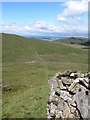
The Moyad Road (B27 Hilltown-Kilkeel road) from the upper slopes of Slieve Muck
by Eric Jones geograph for square J2725 Dist:0.3km Tags: [top:Lakes, Wetland, Bog] [top:Roads, Road transport] [top:Uplands] [top:Water resources] The Spelga Reservoir covers a large area of the valley below.
|
Search took 0.02 secs, ( Page 1 2 3 4 5 6 7 8 ... next >> ) [refine search]
· Login to view KML, GPX, or RSS versions of these results.Expand Word Statistics
Found these results useful? Please Donate
|